Trail Walking Orry-la-Ville - Le tour du grand paris via le GR1  Etape 8 Coye - Dammartin - Photo

Le tour du grand paris via le GR1 Etape 8 Coye - Dammartin

 chessyca
chessyca

User GUIDE

© OpenStreetMap contributors
Length
Length
38 km
Max alt
Max alt
174 m
Uphill gradient
Uphill gradient
415 m
Km-Effort
Km-Effort  
44 km
Min alt
Min alt
45 m
Downhill gradient
Downhill gradient
402 m
Boucle
Boucle
No
Creation date :
2022-04-29 06:40:51.266
Updated on :
2022-04-29 18:02:05.532

(0 Reviews)

Walking
Walking
8h47
Difficulty : Difficult

Scan this QR Code to open this trail in the SityTrail application

FREE GPS app for hiking

Logo SityTrail SityTrail

IGN / Geographical institutes

Download SityTrail from the App Store Download SityTrail from Google Play

Logo SityTrail SityTrail World

The world is yours!

Download SityTrail from the App Store Download SityTrail from Google Play Download SityTrail on Huawei AppGallery

About

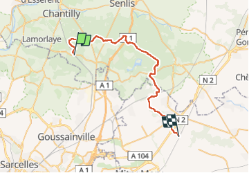
Trail Walking of 38 km to be discovered at Hauts-de-France, Oise, Orry-la-Ville. This trail is proposed by chessyca.

Description

une étape de 38 km incompressible.
Très belle matinée en forêt - L'arrivée sur Dammartin et la traversée de la ville sont bcp moins interessantes.

Elevation profile

Photos

Positioning

Country:
France
Region :
Hauts-de-France
Department/Province :
Oise
Municipality :
Orry-la-Ville
Location:
Unknown
Start:(UTM)
462712 ; 5442924 (31U) N.

Trails nearby

Trail Walking Orry-la-Ville - Dans la forêt des moines - Orry-la-Ville - Photo
Walking
tracegps

Walking

Medium
(2)
Orry-la-Ville, Hauts-de-France, Oise, France
9.2 km | 11.2 km-effort
2h 30min
Yes
Trail Walking Coye-la-Forêt - SM_COYE la FORET_7.9Km - Photo
Walking
GR77LP

Walking

Medium
(5)
Coye-la-Forêt, Hauts-de-France, Oise, France
7.9 km | 10 km-effort
2h 40min
Yes
Trail Walking Orry-la-Ville - SM_MONTGRESIN_EST_8.2Km - Photo
Walking
GR77LP

Walking

Medium
(5)
Orry-la-Ville, Hauts-de-France, Oise, France
8.2 km | 9.2 km-effort
1h 51min
Yes
Trail Walking Pontarmé - MR_PONTARME-OUEST_4.9Km - Photo
Walking
GR77LP

Walking

Easy
(2)
Pontarmé, Hauts-de-France, Oise, France
4.9 km | 5.5 km-effort
1h 12min
Yes
Trail Walking Pontarmé - SM_PONTARME_EST(Chateau)_8.6Km - Photo
Walking

Walking

Medium
(5)
Pontarmé, Hauts-de-France, Oise, France
8.6 km | 9.7 km-effort
2h 9min
Yes
Trail Walking Luzarches - Autour d'Orry la Ville - Photo
Walking
tracegps

Walking

Medium
(1)
Luzarches, Ile-de-France, Val-d'Oise, France
22 km | 26 km-effort
4h 25min
Yes
Trail Walking Orry-la-Ville - La forêt des étangs de Comelle - Orry la Ville - Photo
Walking
tracegps

Walking

Medium
(1)
Orry-la-Ville, Hauts-de-France, Oise, France
11.4 km | 13 km-effort
4h 0min
Yes
Trail Walking Orry-la-Ville - FORET DE COYE BOUCLE 16 KM - Photo
Walking
gemau77

Walking

Very difficult
(1)
Orry-la-Ville, Hauts-de-France, Oise, France
16.3 km | 19.4 km-effort
4h 23min
No
Trail Walking Coye-la-Forêt - Boucle autour des étangs de Commelles - Photo
Walking
GUIDE
chessyca

Walking

Very easy
Coye-la-Forêt, Hauts-de-France, Oise, France
23 km | 26 km-effort
5h 5min
Yes


Close
My subscriptions