![](/images/other/stat-length.png)
![Trail Walking Houyet - GG-NA-20_Gendron-Celles - Dinant - Photo](https://media.geolcdn.com/t/1900/400/ext.pjpeg?maxdim=2&url=https%3A%2F%2Fstatic1.geolcdn.com%2Fsiteimages%2Fupload%2Ffiles%2F1553511878bg_sport_marche.png)
GG-NA-20_Gendron-Celles - Dinant
yamadix
User
![Length](/images/other/stat-length.png)
Length
16.5 km
![Max alt](https://static1.geolcdn.com/siteimages/upload/files/1508320355ic_sort_altitude_max_24dp.png)
Max alt
221 m
![Uphill gradient](https://static1.geolcdn.com/siteimages/upload/files/1508320355ic_sort_den_pos_24dp.png)
Uphill gradient
308 m
![Km-Effort](/images/other/stat-length.png)
Km-Effort
21 km
![Min alt](https://static1.geolcdn.com/siteimages/upload/files/1508320355ic_sort_altitude_min_24dp.png)
Min alt
88 m
![Downhill gradient](https://static1.geolcdn.com/siteimages/upload/files/1508320355ic_sort_den_neg_24dp.png)
Downhill gradient
319 m
![Boucle](https://static1.geolcdn.com/siteimages/upload/files/16400158638029165_repeat_loop_refresh_sync_direction_icon.png)
Boucle
No
Creation date :
2022-04-13 15:55:39.593
Updated on :
2022-04-28 19:09:33.03
![Walking](https://static1.geolcdn.com/sitytour/trail-icons/101.png)
6h55
Difficulty : Very difficult
![Scan this QR Code to open this trail in the SityTrail application](https://capi.geolives.com/qq0zvz2zws4bq2lad0pu/sitytour/trails/3221847/qr.png?size=200)
FREE GPS app for hiking
About
Trail Walking of 16.5 km to be discovered at Wallonia, Namur, Houyet. This trail is proposed by yamadix.
Description
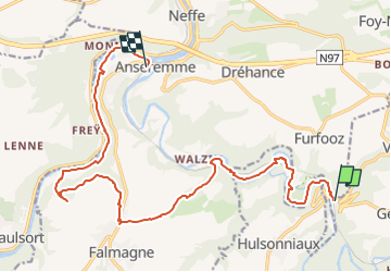
Randonnée de gare à gare, de Gendron à Dinant via Furfooz (bord de Lesse), Falmignoul et Anseremme.
[SNCB ligne 166 - Namur - Libramont via Dinant]
Distance : 17,2 km - Dénivelé : 399 m
Suivre randonnée GR jusqu'à Anseremme (gare)
Positioning
Country:
Belgium
Region :
Wallonia
Department/Province :
Namur
Municipality :
Houyet
Location:
Unknown
Start:(Dec)
Start:(UTM)
640171 ; 5563921 (31U) N.
Comments
Trails nearby
![Walking Walking](https://static1.geolcdn.com/sitytour/trail-icons/101.png)
RB-Na-24-Entre Lesse et Meuse
Walking
Very difficult
(15)
Dinant,
Wallonia,
Namur,
Belgium
![](/images/other/stat-length.png)
19.3 km | 26 km-effort
5h 57min
![](https://static1.geolcdn.com/siteimages/upload/files/16400158638029165_repeat_loop_refresh_sync_direction_icon.png)
Yes
![Trail Walking Houyet - Nature - The Payenne trail (Houyet) - Photo](https://media.geolcdn.com/t/375/260/ext.jpg?maxdim=2&url=https%3A%2F%2Fservices.sitytrail.com%2FGeolivesWS%2FDownloadMedia.ashx%3FTrailID%3D247221%26Media%3D4a1116e4-3cc3-4f81-a279-87cb261b0cef.jpg)
![Walking Walking](https://static1.geolcdn.com/sitytour/trail-icons/101.png)
Nature - The Payenne trail (Houyet)
Walking
Difficult
(5)
Houyet,
Wallonia,
Namur,
Belgium
![](/images/other/stat-length.png)
14.3 km | 19 km-effort
4h 18min
![](https://static1.geolcdn.com/siteimages/upload/files/16400158638029165_repeat_loop_refresh_sync_direction_icon.png)
Yes
![Trail Walking Houyet - Nature - Royal Park walk - Houyet - Photo](https://media.geolcdn.com/t/375/260/ext.jpg?maxdim=2&url=https%3A%2F%2Fservices.sitytrail.com%2FGeolivesWS%2FDownloadMedia.ashx%3FTrailID%3D193546%26Media%3D0a2a8593-cf69-475f-a9b0-b2a4af4f959b.jpg)
![Walking Walking](https://static1.geolcdn.com/sitytour/trail-icons/101.png)
Nature - Royal Park walk - Houyet
Walking
Difficult
(14)
Houyet,
Wallonia,
Namur,
Belgium
![](/images/other/stat-length.png)
5.7 km | 7.8 km-effort
1h 47min
![](https://static1.geolcdn.com/siteimages/upload/files/16400158638029165_repeat_loop_refresh_sync_direction_icon.png)
Yes
![Trail Walking Houyet - Houyet - Pî-sinte po tortos - Walk for everyone - On foot, by bicycle, on horseback, wheelchair accessible - Photo](https://media.geolcdn.com/t/375/260/ext.jpg?maxdim=2&url=https%3A%2F%2Fservices.sitytrail.com%2FGeolivesWS%2FDownloadMedia.ashx%3FTrailID%3D193539%26Media%3D6b85272b-deee-4a79-9526-05b6bf74491c.jpg)
![Walking Walking](https://static1.geolcdn.com/sitytour/trail-icons/101.png)
Houyet - Pî-sinte po tortos - Walk for everyone - On foot, by bicycle, on ho...
Walking
(6)
Houyet,
Wallonia,
Namur,
Belgium
![](/images/other/stat-length.png)
4.3 km | 4.9 km-effort
1h 0min
![](https://static1.geolcdn.com/siteimages/upload/files/16400158638029165_repeat_loop_refresh_sync_direction_icon.png)
Yes
![Trail Walking Houyet - La Lesse, Natura 2000 - Des sites qui valent le détour, Na07 - Photo](https://media.geolcdn.com/t/375/260/ext.jpg?maxdim=2&url=https%3A%2F%2Fservices.sitytrail.com%2FGeolivesWS%2FDownloadMedia.ashx%3FTrailID%3D188163%26Media%3Df0b29f0e-e19a-4fa8-a869-5ab27b1769d7.JPG)
![Walking Walking](https://static1.geolcdn.com/sitytour/trail-icons/101.png)
La Lesse, Natura 2000 - Des sites qui valent le détour, Na07
Walking
Difficult
(9)
Houyet,
Wallonia,
Namur,
Belgium
![](/images/other/stat-length.png)
8.8 km | 11.5 km-effort
2h 33min
![](https://static1.geolcdn.com/siteimages/upload/files/16400158638029165_repeat_loop_refresh_sync_direction_icon.png)
Yes
![Trail Walking Houyet - RB-Na-05 Hauts lieux de la basse Lesse - Photo](https://media.geolcdn.com/t/375/260/ext.jpg?maxdim=2&url=https%3A%2F%2Fservices.sitytrail.com%2FGeolivesWS%2FDownloadMedia.ashx%3FTrailID%3D179631%26Media%3D95d7547e-2b07-4681-8a2a-4a37901ae9c7.jpg)
![Walking Walking](https://static1.geolcdn.com/sitytour/trail-icons/101.png)
RB-Na-05 Hauts lieux de la basse Lesse
Walking
Medium
(9)
Houyet,
Wallonia,
Namur,
Belgium
![](/images/other/stat-length.png)
24 km | 31 km-effort
6h 33min
![](https://static1.geolcdn.com/siteimages/upload/files/16400158638029165_repeat_loop_refresh_sync_direction_icon.png)
Yes
![Trail Walking Houyet - Nature - Houyet, a royal municipality - Photo](https://media.geolcdn.com/t/375/260/ext.jpg?maxdim=2&url=https%3A%2F%2Fservices.sitytrail.com%2FGeolivesWS%2FDownloadMedia.ashx%3FTrailID%3D166040%26Media%3D0a2a8593-cf69-475f-a9b0-b2a4af4f959b.jpg)
![Walking Walking](https://static1.geolcdn.com/sitytour/trail-icons/101.png)
Nature - Houyet, a royal municipality
Walking
Difficult
(14)
Houyet,
Wallonia,
Namur,
Belgium
![](/images/other/stat-length.png)
8.3 km | 11.5 km-effort
2h 33min
![](https://static1.geolcdn.com/siteimages/upload/files/16400158638029165_repeat_loop_refresh_sync_direction_icon.png)
Yes
![Trail Walking Houyet - RB-Na-05 Raccourci 1 - Hauts lieux de la basse Lesse - Photo](https://media.geolcdn.com/t/375/260/ext.jpg?maxdim=2&url=https%3A%2F%2Fservices.sitytrail.com%2FGeolivesWS%2FDownloadMedia.ashx%3FTrailID%3D213753%26Media%3D8bab1d47-4651-4050-8b88-78bf90d52eb5.jpg)
![Walking Walking](https://static1.geolcdn.com/sitytour/trail-icons/101.png)
RB-Na-05 Raccourci 1 - Hauts lieux de la basse Lesse
Walking
Easy
(5)
Houyet,
Wallonia,
Namur,
Belgium
![](/images/other/stat-length.png)
21 km | 26 km-effort
5h 37min
![](https://static1.geolcdn.com/siteimages/upload/files/16400158638029165_repeat_loop_refresh_sync_direction_icon.png)
Yes
![Trail Walking Houyet - Nature & heritage in Celles, one of the Most Beautiful Villages of Wallonia - Photo](https://media.geolcdn.com/t/375/260/ac9d387c-3f8d-401d-bffe-044b71ce3eff.jpg&format=jpg&maxdim=2)
![Walking Walking](https://static1.geolcdn.com/sitytour/trail-icons/101.png)
Nature & heritage in Celles, one of the Most Beautiful Villages of Wallonia
Walking
Medium
(6)
Houyet,
Wallonia,
Namur,
Belgium
![](/images/other/stat-length.png)
9.6 km | 12.7 km-effort
2h 52min
![](https://static1.geolcdn.com/siteimages/upload/files/16400158638029165_repeat_loop_refresh_sync_direction_icon.png)
Yes