![](/images/other/stat-length.png)
![Trail Cycle Montbrun-les-Bains - 13045492 - Photo](https://media.geolcdn.com/t/1900/400/ext.pjpeg?maxdim=2&url=https%3A%2F%2Fstatic1.geolcdn.com%2Fsiteimages%2Fupload%2Ffiles%2F1524743154velo.jpg)
13045492
chris13370
User
![Length](/images/other/stat-length.png)
Length
37 km
![Max alt](https://static1.geolcdn.com/siteimages/upload/files/1508320355ic_sort_altitude_max_24dp.png)
Max alt
1071 m
![Uphill gradient](https://static1.geolcdn.com/siteimages/upload/files/1508320355ic_sort_den_pos_24dp.png)
Uphill gradient
721 m
![Km-Effort](/images/other/stat-length.png)
Km-Effort
47 km
![Min alt](https://static1.geolcdn.com/siteimages/upload/files/1508320355ic_sort_altitude_min_24dp.png)
Min alt
581 m
![Downhill gradient](https://static1.geolcdn.com/siteimages/upload/files/1508320355ic_sort_den_neg_24dp.png)
Downhill gradient
717 m
![Boucle](https://static1.geolcdn.com/siteimages/upload/files/16400158638029165_repeat_loop_refresh_sync_direction_icon.png)
Boucle
Yes
Creation date :
2022-04-23 14:57:37.182
Updated on :
2022-04-23 14:57:37.182
![Cycle](https://static1.geolcdn.com/sitytour/trail-icons/200.png)
--
Difficulty : Unknown
![Scan this QR Code to open this trail in the SityTrail application](https://capi.geolives.com/qq0zvz2zws4bq2lad0pu/sitytour/trails/3215302/qr.png?size=200)
FREE GPS app for hiking
About
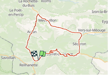
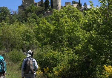
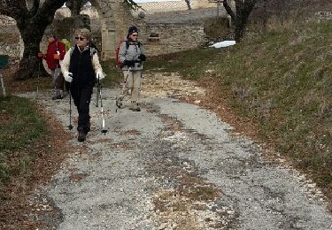
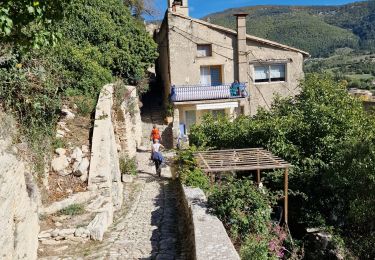
Trail Cycle of 37 km to be discovered at Auvergne-Rhône-Alpes, Drôme, Montbrun-les-Bains. This trail is proposed by chris13370.
Description
Ce circuit vélo au profil altimétrique clément vous emmènera à la découverte de trois vallées du berceau historique des Baronnies provençales.
Positioning
Country:
France
Region :
Auvergne-Rhône-Alpes
Department/Province :
Drôme
Municipality :
Montbrun-les-Bains
Location:
Unknown
Start:(Dec)
Start:(UTM)
695376 ; 4894282 (31T) N.
Comments
Trails nearby
![Trail Walking Montbrun-les-Bains - montbrun buc - Photo](https://media.geolcdn.com/t/375/260/ext.jpg?maxdim=2&url=https%3A%2F%2Fservices.sitytrail.com%2FGeolivesWS%2FDownloadMedia.ashx%3FTrailID%3D345092%26Media%3Dfix__20140914093015.jpg)
![Walking Walking](https://static1.geolcdn.com/sitytour/trail-icons/101.png)
montbrun buc
Walking
Difficult
(1)
Montbrun-les-Bains,
Auvergne-Rhône-Alpes,
Drôme,
France
![](/images/other/stat-length.png)
14.4 km | 26 km-effort
4h 36min
![](https://static1.geolcdn.com/siteimages/upload/files/16400158638029165_repeat_loop_refresh_sync_direction_icon.png)
Yes
![Trail Mountain bike Reilhanette - La Grande Traversée VTT de Vaucluse via Le Luberon - Photo](https://media.geolcdn.com/t/375/260/ext.jpg?maxdim=2&url=https%3A%2F%2Fservices.sitytrail.com%2FGeolivesWS%2FDownloadMedia.ashx%3FTrailID%3D492091%26Media%3Dcb7d4863-e894-44a8-b739-43160282a3da.jpg)
![Mountain bike Mountain bike](https://static1.geolcdn.com/sitytour/trail-icons/202.png)
La Grande Traversée VTT de Vaucluse via Le Luberon
Mountain bike
Difficult
Reilhanette,
Auvergne-Rhône-Alpes,
Drôme,
France
![](/images/other/stat-length.png)
331 km | 463 km-effort
27h 48min
![](https://static1.geolcdn.com/siteimages/upload/files/16400158638029165_repeat_loop_refresh_sync_direction_icon.png)
No
![Trail Cycle Montbrun-les-Bains - montbrun buis Aulan - Photo](https://media.geolcdn.com/t/375/260/ext.jpg?maxdim=2&url=https%3A%2F%2Fstatic1.geolcdn.com%2Fsiteimages%2Fupload%2Ffiles%2F1524743154velo.jpg)
![Cycle Cycle](https://static1.geolcdn.com/sitytour/trail-icons/200.png)
montbrun buis Aulan
Cycle
Medium
(1)
Montbrun-les-Bains,
Auvergne-Rhône-Alpes,
Drôme,
France
![](/images/other/stat-length.png)
59 km | 71 km-effort
2h 49min
![](https://static1.geolcdn.com/siteimages/upload/files/16400158638029165_repeat_loop_refresh_sync_direction_icon.png)
Yes
![Trail Walking Montbrun-les-Bains - Ravin de Courge Chapelle de la Donne - Photo](https://media.geolcdn.com/t/375/260/ext.jpg?maxdim=2&url=https%3A%2F%2Fmedia.geolcdn.com%2Ff%2F92c5fe7d-f874-4815-ab59-14d93fa05740.jpg)
![Walking Walking](https://static1.geolcdn.com/sitytour/trail-icons/101.png)
Ravin de Courge Chapelle de la Donne
Walking
Difficult
Montbrun-les-Bains,
Auvergne-Rhône-Alpes,
Drôme,
France
![](/images/other/stat-length.png)
13.1 km | 21 km-effort
3h 51min
![](https://static1.geolcdn.com/siteimages/upload/files/16400158638029165_repeat_loop_refresh_sync_direction_icon.png)
Yes
![Trail Walking Montbrun-les-Bains - de Montbrun à Reillanette - Photo](https://media.geolcdn.com/t/375/260/ext.jpg?maxdim=2&url=https%3A%2F%2Fmedia.geolcdn.com%2Ff%2F42775911-c5e1-4c67-a118-ad90052c7faa.jpg)
![Walking Walking](https://static1.geolcdn.com/sitytour/trail-icons/101.png)
de Montbrun à Reillanette
Walking
Very easy
Montbrun-les-Bains,
Auvergne-Rhône-Alpes,
Drôme,
France
![](/images/other/stat-length.png)
9.7 km | 13.9 km-effort
5h 43min
![](https://static1.geolcdn.com/siteimages/upload/files/16400158638029165_repeat_loop_refresh_sync_direction_icon.png)
No
![Trail Walking Ferrassières - ferrassiere - Photo](https://media.geolcdn.com/t/375/260/ext.jpg?maxdim=2&url=https%3A%2F%2Fservices.sitytrail.com%2FGeolivesWS%2FDownloadMedia.ashx%3FTrailID%3D396174%26Media%3Dfix__20150313155500.jpg)
![Walking Walking](https://static1.geolcdn.com/sitytour/trail-icons/101.png)
ferrassiere
Walking
Easy
Ferrassières,
Auvergne-Rhône-Alpes,
Drôme,
France
![](/images/other/stat-length.png)
12.8 km | 17 km-effort
4h 40min
![](https://static1.geolcdn.com/siteimages/upload/files/16400158638029165_repeat_loop_refresh_sync_direction_icon.png)
No
![Trail Walking Montbrun-les-Bains - les fontaines de Montbrun et Savoillans - Photo](https://media.geolcdn.com/t/375/260/ext.jpg?maxdim=2&url=https%3A%2F%2Fmedia.geolcdn.com%2Ff%2F5350cb6a-9969-4039-b3f3-b732641e699b.jpg)
![Walking Walking](https://static1.geolcdn.com/sitytour/trail-icons/101.png)
les fontaines de Montbrun et Savoillans
Walking
Easy
Montbrun-les-Bains,
Auvergne-Rhône-Alpes,
Drôme,
France
![](/images/other/stat-length.png)
14.2 km | 18.3 km-effort
5h 59min
![](https://static1.geolcdn.com/siteimages/upload/files/16400158638029165_repeat_loop_refresh_sync_direction_icon.png)
No
![Trail Walking Montbrun-les-Bains - Montbrun ( autour du village ) - Photo](https://media.geolcdn.com/t/375/260/ext.jpg?maxdim=2&url=https%3A%2F%2Fmedia.geolcdn.com%2Ff%2F7a2d4a3b-ecf0-45f1-8463-a19b10dee792.jpg)
![Walking Walking](https://static1.geolcdn.com/sitytour/trail-icons/101.png)
Montbrun ( autour du village )
Walking
Difficult
Montbrun-les-Bains,
Auvergne-Rhône-Alpes,
Drôme,
France
![](/images/other/stat-length.png)
9.7 km | 13.8 km-effort
5h 35min
![](https://static1.geolcdn.com/siteimages/upload/files/16400158638029165_repeat_loop_refresh_sync_direction_icon.png)
Yes
![Trail Walking Ferrassières - du col de l'homme mort à la cabane de Cyprien - Photo](https://media.geolcdn.com/t/375/260/ext.jpg?maxdim=2&url=https%3A%2F%2Fmedia.geolcdn.com%2Ff%2Fbc1f8b7f-6ae8-4dba-95fa-e2185e263a08.jpg)
![Walking Walking](https://static1.geolcdn.com/sitytour/trail-icons/101.png)
du col de l'homme mort à la cabane de Cyprien
Walking
Easy
Ferrassières,
Auvergne-Rhône-Alpes,
Drôme,
France
![](/images/other/stat-length.png)
8.2 km | 13.1 km-effort
3h 52min
![](https://static1.geolcdn.com/siteimages/upload/files/16400158638029165_repeat_loop_refresh_sync_direction_icon.png)
Yes