![](/images/other/stat-length.png)
![Trail Walking Cléry-Saint-André - CLERY Printemps 2022 - Photo](https://media.geolcdn.com/t/1900/400/ext.pjpeg?maxdim=2&url=https%3A%2F%2Fstatic1.geolcdn.com%2Fsiteimages%2Fupload%2Ffiles%2F1553511878bg_sport_marche.png)
CLERY Printemps 2022
Rembliere
User
![Length](/images/other/stat-length.png)
Length
12.3 km
![Max alt](https://static1.geolcdn.com/siteimages/upload/files/1508320355ic_sort_altitude_max_24dp.png)
Max alt
109 m
![Uphill gradient](https://static1.geolcdn.com/siteimages/upload/files/1508320355ic_sort_den_pos_24dp.png)
Uphill gradient
74 m
![Km-Effort](/images/other/stat-length.png)
Km-Effort
13.3 km
![Min alt](https://static1.geolcdn.com/siteimages/upload/files/1508320355ic_sort_altitude_min_24dp.png)
Min alt
87 m
![Downhill gradient](https://static1.geolcdn.com/siteimages/upload/files/1508320355ic_sort_den_neg_24dp.png)
Downhill gradient
74 m
![Boucle](https://static1.geolcdn.com/siteimages/upload/files/16400158638029165_repeat_loop_refresh_sync_direction_icon.png)
Boucle
Yes
Creation date :
2022-04-17 14:24:39.128
Updated on :
2022-04-17 14:39:54.268
![Walking](https://static1.geolcdn.com/sitytour/trail-icons/101.png)
3h01
Difficulty : Difficult
![Scan this QR Code to open this trail in the SityTrail application](https://capi.geolives.com/qq0zvz2zws4bq2lad0pu/sitytour/trails/3208177/qr.png?size=200)
FREE GPS app for hiking
About
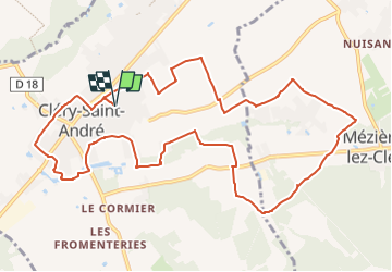
Trail Walking of 12.3 km to be discovered at Centre-Loire Valley, Loiret, Cléry-Saint-André. This trail is proposed by Rembliere.
Description
Le collège les génetieres, La déchetterie, Rolland, Manthelon, la bute des élus, le gué de l'Ardoux, le château des élus, les Bonshommes, les Bordes, l'Ardoux, le stade, rue de maisons rouge, s chemin des Bergerets retour par les entiers jusqu'au collège
Positioning
Country:
France
Region :
Centre-Loire Valley
Department/Province :
Loiret
Municipality :
Cléry-Saint-André
Location:
Unknown
Start:(Dec)
Start:(UTM)
407366 ; 5297338 (31T) N.
Comments
Trails nearby
![Trail Walking Saint-Ay - ST AY bords de Loire 2 - Photo](https://media.geolcdn.com/t/375/260/ext.jpg?maxdim=2&url=https%3A%2F%2Fstatic1.geolcdn.com%2Fsiteimages%2Fupload%2Ffiles%2F1553511878bg_sport_marche.png)
![Walking Walking](https://static1.geolcdn.com/sitytour/trail-icons/101.png)
ST AY bords de Loire 2
Walking
Difficult
(1)
Saint-Ay,
Centre-Loire Valley,
Loiret,
France
![](/images/other/stat-length.png)
12 km | 13.4 km-effort
2h 57min
![](https://static1.geolcdn.com/siteimages/upload/files/16400158638029165_repeat_loop_refresh_sync_direction_icon.png)
Yes
![Trail Mountain bike Mézières-lez-Cléry - Les élus Mézière - Photo](https://media.geolcdn.com/t/375/260/ext.jpg?maxdim=2&url=https%3A%2F%2Fservices.sitytrail.com%2FGeolivesWS%2FDownloadMedia.ashx%3FTrailID%3D102853%26Media%3D4026_6.jpg)
![Mountain bike Mountain bike](https://static1.geolcdn.com/sitytour/trail-icons/202.png)
Les élus Mézière
Mountain bike
Medium
Mézières-lez-Cléry,
Centre-Loire Valley,
Loiret,
France
![](/images/other/stat-length.png)
13.1 km | 14.4 km-effort
1h 19min
![](https://static1.geolcdn.com/siteimages/upload/files/16400158638029165_repeat_loop_refresh_sync_direction_icon.png)
Yes
![Trail Walking Mézières-lez-Cléry - Les élus Mézière - Photo](https://media.geolcdn.com/t/375/260/ext.jpg?maxdim=2&url=https%3A%2F%2Fservices.sitytrail.com%2FGeolivesWS%2FDownloadMedia.ashx%3FTrailID%3D102852%26Media%3D4026_6.jpg)
![Walking Walking](https://static1.geolcdn.com/sitytour/trail-icons/101.png)
Les élus Mézière
Walking
Easy
Mézières-lez-Cléry,
Centre-Loire Valley,
Loiret,
France
![](/images/other/stat-length.png)
13.1 km | 14.4 km-effort
3h 30min
![](https://static1.geolcdn.com/siteimages/upload/files/16400158638029165_repeat_loop_refresh_sync_direction_icon.png)
Yes
![Trail Walking Mézières-lez-Cléry - mezieres fevrier 2023 - Photo](https://media.geolcdn.com/t/375/260/8e9bc008-e738-437d-a2d1-3e242f15dba1.jpg&format=jpg&maxdim=2)
![Walking Walking](https://static1.geolcdn.com/sitytour/trail-icons/101.png)
mezieres fevrier 2023
Walking
Medium
Mézières-lez-Cléry,
Centre-Loire Valley,
Loiret,
France
![](/images/other/stat-length.png)
10.6 km | 11.8 km-effort
2h 28min
![](https://static1.geolcdn.com/siteimages/upload/files/16400158638029165_repeat_loop_refresh_sync_direction_icon.png)
Yes
![Trail Walking Mézières-lez-Cléry - Mézières 6 juin 2021 - Photo](https://media.geolcdn.com/t/375/260/4ed21d7b-41f3-437d-bfd5-510784e977d6.jpg&format=jpg&maxdim=2)
![Walking Walking](https://static1.geolcdn.com/sitytour/trail-icons/101.png)
Mézières 6 juin 2021
Walking
Medium
Mézières-lez-Cléry,
Centre-Loire Valley,
Loiret,
France
![](/images/other/stat-length.png)
9.9 km | 10.9 km-effort
3h 7min
![](https://static1.geolcdn.com/siteimages/upload/files/16400158638029165_repeat_loop_refresh_sync_direction_icon.png)
Yes
![Trail Mountain bike Meung-sur-Loire - Les deux ponts - Meung sur Loire - Beaugency - Photo](https://media.geolcdn.com/t/375/260/ext.jpg?maxdim=2&url=https%3A%2F%2Fservices.sitytrail.com%2FGeolivesWS%2FDownloadMedia.ashx%3FTrailID%3D103577%26Media%3D5908_2.jpg)
![Mountain bike Mountain bike](https://static1.geolcdn.com/sitytour/trail-icons/202.png)
Les deux ponts - Meung sur Loire - Beaugency
Mountain bike
Medium
Meung-sur-Loire,
Centre-Loire Valley,
Loiret,
France
![](/images/other/stat-length.png)
17.1 km | 18.4 km-effort
2h 0min
![](https://static1.geolcdn.com/siteimages/upload/files/16400158638029165_repeat_loop_refresh_sync_direction_icon.png)
Yes
![Trail Walking Meung-sur-Loire - Les deux ponts - Meung sur Loire - Beaugency - Photo](https://media.geolcdn.com/t/375/260/ext.jpg?maxdim=2&url=https%3A%2F%2Fservices.sitytrail.com%2FGeolivesWS%2FDownloadMedia.ashx%3FTrailID%3D103576%26Media%3D5908_2.jpg)
![Walking Walking](https://static1.geolcdn.com/sitytour/trail-icons/101.png)
Les deux ponts - Meung sur Loire - Beaugency
Walking
Medium
Meung-sur-Loire,
Centre-Loire Valley,
Loiret,
France
![](/images/other/stat-length.png)
17.1 km | 18.4 km-effort
4h 0min
![](https://static1.geolcdn.com/siteimages/upload/files/16400158638029165_repeat_loop_refresh_sync_direction_icon.png)
Yes
![Trail Cycle Cléry-Saint-André - Cléry Saint André - Photo](https://media.geolcdn.com/t/375/260/ext.jpg?maxdim=2&url=https%3A%2F%2Fservices.sitytrail.com%2FGeolivesWS%2FDownloadMedia.ashx%3FTrailID%3D102657%26Media%3D3666_2.jpg)
![Cycle Cycle](https://static1.geolcdn.com/sitytour/trail-icons/200.png)
Cléry Saint André
Cycle
Easy
Cléry-Saint-André,
Centre-Loire Valley,
Loiret,
France
![](/images/other/stat-length.png)
19.2 km | 20 km-effort
1h 45min
![](https://static1.geolcdn.com/siteimages/upload/files/16400158638029165_repeat_loop_refresh_sync_direction_icon.png)
Yes
![Trail sport Cléry-Saint-André - Sob 7 clery ferte St Cyr - Photo](https://media.geolcdn.com/t/375/260/ce887a6e-1c86-46c1-80c8-24fbf8d76772.jpg&format=jpg&maxdim=2)
Sob 7 clery ferte St Cyr
sport
Very easy
Cléry-Saint-André,
Centre-Loire Valley,
Loiret,
France
![](/images/other/stat-length.png)
24 km | 26 km-effort
Unknown
![](https://static1.geolcdn.com/siteimages/upload/files/16400158638029165_repeat_loop_refresh_sync_direction_icon.png)
No