Trail Cycle Bédoin - Mont Ventoux par Sault - Photo
 bosses21
bosses21

User

© OpenStreetMap contributors
Length
Length
89 km
Max alt
Max alt
1902 m
Uphill gradient
Uphill gradient
2316 m
Km-Effort
Km-Effort  
119 km
Min alt
Min alt
304 m
Downhill gradient
Downhill gradient
2315 m
Boucle
Boucle
Yes
Creation date :
2014-12-10 00:00:00.0
Updated on :
2014-12-10 00:00:00.0

(0 Reviews)

Cycle
Cycle
6h43
Difficulty : Difficult

Scan this QR Code to open this trail in the SityTrail application

FREE GPS app for hiking

Logo SityTrail SityTrail

IGN / Geographical institutes

Download SityTrail from the App Store Download SityTrail from Google Play

Logo SityTrail SityTrail World

The world is yours!

Download SityTrail from the App Store Download SityTrail from Google Play Download SityTrail on Huawei AppGallery

About

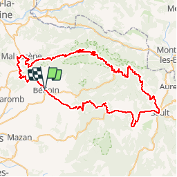
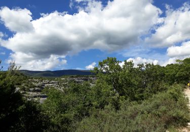
Trail Cycle of 89 km to be discovered at Provence-Alpes-Côte d'Azur, Vaucluse, Bédoin. This trail is proposed by bosses21.

Description

1. Col de Notre Dame des Abeilles - 996m
2. Col des Tempêtes - 1829m
3. Mont Ventoux - 1911m
4. Col de la Madeleine - 448m

Elevation profile

Points of interest

Point of interest Bédoin - Mont Ventoux - 1911m - Photo
bosses21
Point of interest Crillon-le-Brave - Col de la Madeleine - 448m - Photo
bosses21
CRILLON-LE-BRAVE 

Positioning

Country:
France
Region :
Provence-Alpes-Côte d'Azur
Department/Province :
Vaucluse
Municipality :
Bédoin
Location:
Unknown
Start:(Dec)
Start:(UTM)
674435 ; 4888077 (31T) N.

Trails nearby

Trail Walking Bédoin - DEMOISELLES COIFFEES  A BEDOIN - Photo
Walking
FLORENSAC

Walking

Medium
(1)
Bédoin, Provence-Alpes-Côte d'Azur, Vaucluse, France
18.8 km | 25 km-effort
6h 1min
Yes
Trail Walking Bédoin - Le Mont Ventoux en randonnée par Saint Colombe - Photo
Walking
tracegps

Walking

Difficult
(1)
Bédoin, Provence-Alpes-Côte d'Azur, Vaucluse, France
24 km | 44 km-effort
6h 49min
Yes
Trail Walking Crillon-le-Brave - Torrent Pied Blanc / Rocher de la Madeleine - Photo
Walking
GUIDE
supercolas

Walking

Medium
Crillon-le-Brave, Provence-Alpes-Côte d'Azur, Vaucluse, France
8.2 km | 11.5 km-effort
2h 18min
Yes
Trail Walking Bédoin - Baume du Chat final par les Siarres - Photo
Walking
GUIDE
supercolas

Walking

Medium
Bédoin, Provence-Alpes-Côte d'Azur, Vaucluse, France
8.3 km | 15.6 km-effort
2h 27min
Yes
Trail Walking Caromb - Les 3 Termes 449 le Groseau - Photo
Walking
GUIDE
supercolas

Walking

Medium
Caromb, Provence-Alpes-Côte d'Azur, Vaucluse, France
11.1 km | 16.9 km-effort
2h 56min
Yes
Trail Walking Bédoin - Sud Ventoux et Combe de Curnier  - Photo
Walking
GUIDE
nadinebondoux

Walking

Difficult
Bédoin, Provence-Alpes-Côte d'Azur, Vaucluse, France
16 km | 29 km-effort
6h 28min
Yes
Trail Walking Bédoin - P.Partie Ventoux sud - Photo
Walking
MarcLEBARON

Walking

Difficult
(1)
Bédoin, Provence-Alpes-Côte d'Azur, Vaucluse, France
19.3 km | 35 km-effort
5h 49min
Yes
Trail Walking Bédoin - Bedoin Le Gros Pata - Photo
Walking
alainbarrot

Walking

Medium
(1)
Bédoin, Provence-Alpes-Côte d'Azur, Vaucluse, France
13.7 km | 19.6 km-effort
4h 6min
Yes
Trail Walking Bédoin - Christmas Day / Les Demoiselles coiffées - Photo
Walking
GUIDE
supercolas

Walking

Easy
Bédoin, Provence-Alpes-Côte d'Azur, Vaucluse, France
3.4 km | 4.2 km-effort
56min
Yes


Close
My subscriptions