Trail Cycle Saint-Cyprien - Pyrénées Orientales 5 - Photo
 bosses21
bosses21

User

© OpenStreetMap contributors
Length
Length
117 km
Max alt
Max alt
756 m
Uphill gradient
Uphill gradient
2014 m
Km-Effort
Km-Effort  
144 km
Min alt
Min alt
2 m
Downhill gradient
Downhill gradient
2014 m
Boucle
Boucle
Yes
Creation date :
2014-12-10 00:00:00.0
Updated on :
2014-12-10 00:00:00.0

(1 Reviews)

Cycle
Cycle
8h11
Difficulty : Difficult

Scan this QR Code to open this trail in the SityTrail application

FREE GPS app for hiking

Logo SityTrail SityTrail

IGN / Geographical institutes

Download SityTrail from the App Store Download SityTrail from Google Play

Logo SityTrail SityTrail World

The world is yours!

Download SityTrail from the App Store Download SityTrail from Google Play Download SityTrail on Huawei AppGallery

About

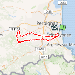
Trail Cycle of 117 km to be discovered at Occitania, Pyrénées-Orientales, Saint-Cyprien. This trail is proposed by bosses21.

Description

1. Als Colls - 283m
2. Col de Creu - 383m
3. Collade des Planes - 415m
4. Col de la Font Rouge - 465m
5. Col de la Croix de la Falibe - 435m
6. Col Sainte Marguerite - 606m
7. Col Fourtou - 646m
8. Col del Fang - 655m
9. Col del Ram - 668m
10. Col Xatard - 752m
11. Col de Prunet - 616m
12. Col de N-D d'el Coll - 505m

Elevation profile

Points of interest

Point of interest Castelnou - Als Colls - 283m - Photo
bosses21
CASTELNOU 
Point of interest Castelnou - Col de Creu - 383m - Photo
bosses21
Point of interest Camélas - Collade des Planes - 415m - Photo
bosses21
Point of interest Prunet-et-Belpuig - Col Fourtou - 646m - Photo
bosses21
PRUNET-ET-BELPUIG 
Point of interest Prunet-et-Belpuig - Col del Fang - 655m - Photo
bosses21
PRUNET-ET-BELPUIG 
Point of interest Prunet-et-Belpuig - Col del Ram - 668m - Photo
bosses21
PRUNET-ET-BELPUIG 
Point of interest Prunet-et-Belpuig - Col Xatard - 752m - Photo
bosses21
PRUNET-ET-BELPUIG 
Point of interest Prunet-et-Belpuig - Col de Prunet - 616m - Photo
bosses21
PRUNET-ET-BELPUIG 
Point of interest Calmeilles - Col de N-D d'el Coll - 505m - Photo
bosses21

Positioning

Country:
France
Region :
Occitania
Department/Province :
Pyrénées-Orientales
Municipality :
Saint-Cyprien
Location:
Unknown
Start:(UTM)
500111 ; 4718980 (31T) N.

Comments

Please log in to post a review or rate the element


Trails nearby

Trail Walking Théza - 66 THEZA - CORNEILLA-DEL-VERCOL - Photo
Walking
jeff66

Walking

Easy
(2)
Théza, Occitania, Pyrénées-Orientales, France
7 km | 7.5 km-effort
1h 8min
Yes
Trail Walking Saint-Cyprien - SAINT-CYPRIEN 66 - front de mer - les CAPELLANS - Photo
Walking
jeff66

Walking

Easy
(2)
Saint-Cyprien, Occitania, Pyrénées-Orientales, France
9.9 km | 10.3 km-effort
2h 11min
Yes
Trail Equestrian Saint-Cyprien - bocal du Tech - Photo
Equestrian
sandymocko

Equestrian

Medium
(1)
Saint-Cyprien, Occitania, Pyrénées-Orientales, France
17 km | 17.7 km-effort
3h 20min
Yes
Trail Walking Saleilles - 66 SALEILLES - St-NAZAIRE, entre FOSSEILLE et REART - Photo
Walking
jeff66

Walking

Easy
(1)
Saleilles, Occitania, Pyrénées-Orientales, France
7.3 km | 7.7 km-effort
1h 8min
Yes
Trail Walking Argelès-sur-Mer - mas larrieu - argeles / l hiver - Photo
Walking
GUIDE
stef789

Walking

Medium
Argelès-sur-Mer, Occitania, Pyrénées-Orientales, France
8.7 km | 9.1 km-effort
2h 17min
Yes
Trail Walking Argelès-sur-Mer - réserve du mas Larrieu de part et d autre du Tech - Photo
Walking
GUIDE
stef789

Walking

Medium
Argelès-sur-Mer, Occitania, Pyrénées-Orientales, France
5.9 km | 6.1 km-effort
2h 12min
Yes
Trail Walking Saint-Cyprien - st cyprien les monges. St cyprien plage . St cyprien port . capellans . retour les monges  - Photo
Walking
GUIDE
stef789

Walking

Easy
Saint-Cyprien, Occitania, Pyrénées-Orientales, France
10.7 km | 11.2 km-effort
2h 20min
Yes
Trail Walking Argelès-sur-Mer - réserve du mas larrieu - argeles / via la plage et retour via les terres et le tech  - Photo
Walking
GUIDE
stef789

Walking

Easy
Argelès-sur-Mer, Occitania, Pyrénées-Orientales, France
11 km | 11.5 km-effort
3h 41min
Yes
Trail Walking Saint-Cyprien - petit tour à St Cyprien  - Photo
Walking
GUIDE
stef789

Walking

Easy
Saint-Cyprien, Occitania, Pyrénées-Orientales, France
10.4 km | 10.9 km-effort
3h 6min
Yes


Close
My subscriptions