![](/images/other/stat-length.png)
![Trail Walking Évry-Grégy-sur-Yerre - Les ponts d'Evry-Gégy sur Yerres - Photo](https://media.geolcdn.com/t/1900/400/62c2e206-cdad-40b9-bc9c-b3b7091fd90a.jpg&format=pjpeg&maxdim=2)
Les ponts d'Evry-Gégy sur Yerres
dmatignon
User
![Length](/images/other/stat-length.png)
Length
11.8 km
![Max alt](https://static1.geolcdn.com/siteimages/upload/files/1508320355ic_sort_altitude_max_24dp.png)
Max alt
94 m
![Uphill gradient](https://static1.geolcdn.com/siteimages/upload/files/1508320355ic_sort_den_pos_24dp.png)
Uphill gradient
127 m
![Km-Effort](/images/other/stat-length.png)
Km-Effort
13.5 km
![Min alt](https://static1.geolcdn.com/siteimages/upload/files/1508320355ic_sort_altitude_min_24dp.png)
Min alt
52 m
![Downhill gradient](https://static1.geolcdn.com/siteimages/upload/files/1508320355ic_sort_den_neg_24dp.png)
Downhill gradient
125 m
![Boucle](https://static1.geolcdn.com/siteimages/upload/files/16400158638029165_repeat_loop_refresh_sync_direction_icon.png)
Boucle
Yes
Creation date :
2022-04-12 08:12:24.123
Updated on :
2022-04-12 14:26:03.537
![Walking](https://static1.geolcdn.com/sitytour/trail-icons/101.png)
2h31
Difficulty : Medium
![Scan this QR Code to open this trail in the SityTrail application](https://capi.geolives.com/qq0zvz2zws4bq2lad0pu/sitytour/trails/3201526/qr.png?size=200)
FREE GPS app for hiking
About
Trail Walking of 11.8 km to be discovered at Ile-de-France, Seine-et-Marne, Évry-Grégy-sur-Yerre. This trail is proposed by dmatignon.
Description
Randonnée d'une douzaine de km permettant de découvrir les ponts et passerelles sur l'Yerres au départ d'Evry-les-Châteaux, en passant par le prieuré de Vernelle.
Positioning
Country:
France
Region :
Ile-de-France
Department/Province :
Seine-et-Marne
Municipality :
Évry-Grégy-sur-Yerre
Location:
Évry-les-Châteaux
Start:(Dec)
Start:(UTM)
472822 ; 5389058 (31U) N.
Comments
Trails nearby
![Trail Walking Brie-Comte-Robert - brie comte robert - Photo](https://media.geolcdn.com/t/375/260/ext.jpg?maxdim=2&url=https%3A%2F%2Fservices.sitytrail.com%2FGeolivesWS%2FDownloadMedia.ashx%3FTrailID%3D172162%26Media%3D20130130123759.jpeg)
![Walking Walking](https://static1.geolcdn.com/sitytour/trail-icons/101.png)
brie comte robert
Walking
Easy
(2)
Brie-Comte-Robert,
Ile-de-France,
Seine-et-Marne,
France
![](/images/other/stat-length.png)
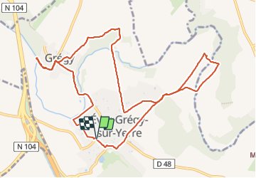
16.7 km | 18.8 km-effort
4h 21min
![](https://static1.geolcdn.com/siteimages/upload/files/16400158638029165_repeat_loop_refresh_sync_direction_icon.png)
Yes
![Trail Walking Évry-Grégy-sur-Yerre - J 55 miguelmillepattes Evry Grégy sur Yerres - Prieuré de Vernelle - Photo](https://media.geolcdn.com/t/375/260/838bff98-2775-4bd0-83b3-89163c602221.jpg&format=jpg&maxdim=2)
![Walking Walking](https://static1.geolcdn.com/sitytour/trail-icons/101.png)
J 55 miguelmillepattes Evry Grégy sur Yerres - Prieuré de Vernelle
Walking
Medium
(2)
Évry-Grégy-sur-Yerre,
Ile-de-France,
Seine-et-Marne,
France
![](/images/other/stat-length.png)
11.9 km | 13.6 km-effort
3h 5min
![](https://static1.geolcdn.com/siteimages/upload/files/16400158638029165_repeat_loop_refresh_sync_direction_icon.png)
Yes
![Trail Walking Coubert - JC 27 Coubert, Solers cimetière allemand, Prieuré de Vernelle - Photo](https://media.geolcdn.com/t/375/260/b6b52968-ca6b-4031-862f-615df2d504ec.jpg&format=jpg&maxdim=2)
![Walking Walking](https://static1.geolcdn.com/sitytour/trail-icons/101.png)
JC 27 Coubert, Solers cimetière allemand, Prieuré de Vernelle
Walking
Difficult
(1)
Coubert,
Ile-de-France,
Seine-et-Marne,
France
![](/images/other/stat-length.png)
20 km | 23 km-effort
5h 11min
![](https://static1.geolcdn.com/siteimages/upload/files/16400158638029165_repeat_loop_refresh_sync_direction_icon.png)
Yes
![Trail Walking Soignolles-en-Brie - Boucle 21 km autour des gués de l'Yerres depuis Soignolles - Photo](https://media.geolcdn.com/t/375/260/4a83274c-359b-40dc-b8c1-30aceeb71fda.jpg&format=jpg&maxdim=2)
![Walking Walking](https://static1.geolcdn.com/sitytour/trail-icons/101.png)
Boucle 21 km autour des gués de l'Yerres depuis Soignolles
Walking
Very easy
Soignolles-en-Brie,
Ile-de-France,
Seine-et-Marne,
France
![](/images/other/stat-length.png)
21 km | 24 km-effort
4h 33min
![](https://static1.geolcdn.com/siteimages/upload/files/16400158638029165_repeat_loop_refresh_sync_direction_icon.png)
Yes
![Trail Walking Brie-Comte-Robert - AdxBCR12,3PlaineChvry - Photo](https://media.geolcdn.com/t/375/260/ext.jpg?maxdim=2&url=https%3A%2F%2Fstatic1.geolcdn.com%2Fsiteimages%2Fupload%2Ffiles%2F1553511878bg_sport_marche.png)
![Walking Walking](https://static1.geolcdn.com/sitytour/trail-icons/101.png)
AdxBCR12,3PlaineChvry
Walking
Difficult
(1)
Brie-Comte-Robert,
Ile-de-France,
Seine-et-Marne,
France
![](/images/other/stat-length.png)
13.4 km | 14.1 km-effort
3h 11min
![](https://static1.geolcdn.com/siteimages/upload/files/16400158638029165_repeat_loop_refresh_sync_direction_icon.png)
Yes
![Trail Walking Brie-Comte-Robert - AdxBCR25MandreMarolles - Photo](https://media.geolcdn.com/t/375/260/ext.jpg?maxdim=2&url=https%3A%2F%2Fstatic1.geolcdn.com%2Fsiteimages%2Fupload%2Ffiles%2F1553511878bg_sport_marche.png)
![Walking Walking](https://static1.geolcdn.com/sitytour/trail-icons/101.png)
AdxBCR25MandreMarolles
Walking
Difficult
(1)
Brie-Comte-Robert,
Ile-de-France,
Seine-et-Marne,
France
![](/images/other/stat-length.png)
13.6 km | 14.9 km-effort
3h 23min
![](https://static1.geolcdn.com/siteimages/upload/files/16400158638029165_repeat_loop_refresh_sync_direction_icon.png)
Yes
![Trail On foot Évry-Grégy-sur-Yerre - TRACES_VISIBLES - Photo](https://media.geolcdn.com/t/375/260/ext.jpg?maxdim=2&url=https%3A%2F%2Fstatic1.geolcdn.com%2Fsiteimages%2Fupload%2Ffiles%2F1545311037marcheuse_200dpi.jpg)
![On foot On foot](https://static1.geolcdn.com/sitytour/trail-icons/100.png)
TRACES_VISIBLES
On foot
Medium
(1)
Évry-Grégy-sur-Yerre,
Ile-de-France,
Seine-et-Marne,
France
![](/images/other/stat-length.png)
10.8 km | 12.6 km-effort
2h 51min
![](https://static1.geolcdn.com/siteimages/upload/files/16400158638029165_repeat_loop_refresh_sync_direction_icon.png)
Yes
![Trail Walking Coubert - on edp-parcours.com - Photo](https://media.geolcdn.com/t/375/260/ext.jpg?maxdim=2&url=https%3A%2F%2Fstatic1.geolcdn.com%2Fsiteimages%2Fupload%2Ffiles%2F1553511878bg_sport_marche.png)
![Walking Walking](https://static1.geolcdn.com/sitytour/trail-icons/101.png)
on edp-parcours.com
Walking
Difficult
(3)
Coubert,
Ile-de-France,
Seine-et-Marne,
France
![](/images/other/stat-length.png)
11.5 km | 12.7 km-effort
2h 53min
![](https://static1.geolcdn.com/siteimages/upload/files/16400158638029165_repeat_loop_refresh_sync_direction_icon.png)
Yes
![Trail On foot Combs-la-Ville - L 35 Combs la Ville Hameau de la Sansonne - Photo](https://media.geolcdn.com/t/375/260/ext.jpg?maxdim=2&url=https%3A%2F%2Fstatic1.geolcdn.com%2Fsiteimages%2Fupload%2Ffiles%2F1545311037marcheuse_200dpi.jpg)
![On foot On foot](https://static1.geolcdn.com/sitytour/trail-icons/100.png)
L 35 Combs la Ville Hameau de la Sansonne
On foot
Easy
(4)
Combs-la-Ville,
Ile-de-France,
Seine-et-Marne,
France
![](/images/other/stat-length.png)
7.7 km | 8.3 km-effort
1h 52min
![](https://static1.geolcdn.com/siteimages/upload/files/16400158638029165_repeat_loop_refresh_sync_direction_icon.png)
Yes
Bien