![](/images/other/stat-length.png)
![Trail Walking Colombières-sur-Orb - les gorges de la colombière par le refuge de font salesse - Photo](https://media.geolcdn.com/t/1900/400/ext.pjpeg?maxdim=2&url=https%3A%2F%2Fstatic1.geolcdn.com%2Fsiteimages%2Fupload%2Ffiles%2F1553511878bg_sport_marche.png)
les gorges de la colombière par le refuge de font salesse
furaxdu26
User
![Length](/images/other/stat-length.png)
![Max alt](https://static1.geolcdn.com/siteimages/upload/files/1508320355ic_sort_altitude_max_24dp.png)
![Uphill gradient](https://static1.geolcdn.com/siteimages/upload/files/1508320355ic_sort_den_pos_24dp.png)
![Km-Effort](/images/other/stat-length.png)
![Min alt](https://static1.geolcdn.com/siteimages/upload/files/1508320355ic_sort_altitude_min_24dp.png)
![Downhill gradient](https://static1.geolcdn.com/siteimages/upload/files/1508320355ic_sort_den_neg_24dp.png)
![Boucle](https://static1.geolcdn.com/siteimages/upload/files/16400158638029165_repeat_loop_refresh_sync_direction_icon.png)
![Walking](https://static1.geolcdn.com/sitytour/trail-icons/101.png)
7h06
Difficulty : Very difficult
![Scan this QR Code to open this trail in the SityTrail application](https://capi.geolives.com/qq0zvz2zws4bq2lad0pu/sitytour/trails/3198285/qr.png?size=200)
FREE GPS app for hiking
About
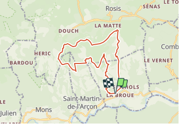
Trail Walking of 16.8 km to be discovered at Occitania, Hérault, Colombières-sur-Orb. This trail is proposed by furaxdu26.
Description
départ depuis le parking de l'église de colombière sur Orb, montée par le sentier L'esquino d'Aze jusqu'au col de la baume de roucayral. Prendre à droite le sentier jusqu'au bastion et col de siègeet rejoindre le chemin qui part sur la droite en direction du GR7
Laiser ce chemin et prendre à gauche qui descend jusqu' à l'altitude de 955m et une intersection
A l'intersection prendre à droite et remonter vers le roc mato-capel et continuer sur ce sentier jusqu'au roc du boutou à 996m jusqu'à une intersection
A l'intersection prenez à droite vers le refuge de font salesse.
Avant le refuge bifurquez à gauche direction la table d'orientation 1037m pour quelques photos du panorama donnant vue sur le caroucx la vallée de l'Orb et la mer au loin.
Ensuite direction l refuge de font salesse pour la pause casse croute.1045m
de là selon votre forme soit vous suivez le GR7 jusqu'à LA FAGE pour rejoindre et rentrer par les gorges de la colombière soit vous élargissez pour faire autour de 17km de rando
Pour élargir prenez direction l'ouest depuis le refuge vers le plo de la maurelle 1055m et suivez ce sentier qui va contourner le lieu dit Font salesse (et non le refuge) pour venir coupe le GR7 au niveau des ruines de Jasse l'hermite pour filer vers le rocGros à 1085m
Continuez sur ce sentier vers la Jase d'Alingri 1063m puis grimpez vers la Bne La tour à 1091m et redescendre vers le GR7 pour ensuite prendre à gauche vers le hameau de LA FAGE et rentrer par les gorges de la colombières jusqu' la patte d'oie (intersection), où il faudra rester à droite pour rejoindre le parking de l'église sinon vous arriverez au parking de la mairie
Positioning
Comments
Trails nearby
![Trail Walking Colombières-sur-Orb - Colombières sur Orb - Photo](https://media.geolcdn.com/t/375/260/ext.jpg?maxdim=2&url=https%3A%2F%2Fservices.sitytrail.com%2FGeolivesWS%2FDownloadMedia.ashx%3FTrailID%3D350907%26Media%3Dfix__20140914134818.jpg)
![Walking Walking](https://static1.geolcdn.com/sitytour/trail-icons/101.png)
Walking
![](/images/other/stat-length.png)
![](https://static1.geolcdn.com/siteimages/upload/files/16400158638029165_repeat_loop_refresh_sync_direction_icon.png)
![Trail Walking Colombières-sur-Orb - Les gorges de Colombières - Photo](https://media.geolcdn.com/t/375/260/ext.jpg?maxdim=2&url=https%3A%2F%2Fservices.sitytrail.com%2FGeolivesWS%2FDownloadMedia.ashx%3FTrailID%3D335244%26Media%3Dfix__20140805142334.jpg)
![Walking Walking](https://static1.geolcdn.com/sitytour/trail-icons/101.png)
Walking
![](/images/other/stat-length.png)
![](https://static1.geolcdn.com/siteimages/upload/files/16400158638029165_repeat_loop_refresh_sync_direction_icon.png)
![Trail Walking Colombières-sur-Orb - Les gorges de Colombières - retour sentier de la Buffe - Photo](https://media.geolcdn.com/t/375/260/ext.jpg?maxdim=2&url=https%3A%2F%2Fservices.sitytrail.com%2FGeolivesWS%2FDownloadMedia.ashx%3FTrailID%3D129712%26Media%3D13257_6.jpg)
![Walking Walking](https://static1.geolcdn.com/sitytour/trail-icons/101.png)
Walking
![](/images/other/stat-length.png)
![](https://static1.geolcdn.com/siteimages/upload/files/16400158638029165_repeat_loop_refresh_sync_direction_icon.png)
![Trail Walking Rosis - Petit tour du plateau du Caroux - Photo](https://media.geolcdn.com/t/375/260/ext.jpg?maxdim=2&url=https%3A%2F%2Fservices.sitytrail.com%2FGeolivesWS%2FDownloadMedia.ashx%3FTrailID%3D109006%26Media%3D2950_1.jpg)
![Walking Walking](https://static1.geolcdn.com/sitytour/trail-icons/101.png)
Walking
![](/images/other/stat-length.png)
![](https://static1.geolcdn.com/siteimages/upload/files/16400158638029165_repeat_loop_refresh_sync_direction_icon.png)
![Trail Walking Colombières-sur-Orb - 34 colombier sur orb - Photo](https://media.geolcdn.com/t/375/260/ed1e5c61-79a3-4908-ab1a-6d651ba5ba36.jpg&format=jpg&maxdim=2)
![Walking Walking](https://static1.geolcdn.com/sitytour/trail-icons/101.png)
Walking
![](/images/other/stat-length.png)
![](https://static1.geolcdn.com/siteimages/upload/files/16400158638029165_repeat_loop_refresh_sync_direction_icon.png)
![Trail Walking Saint-Martin-de-l'Arçon - 34 caroux - Photo](https://media.geolcdn.com/t/375/260/68524901-f808-4b7c-83cf-daed4ea0a516.jpg&format=jpg&maxdim=2)
![Walking Walking](https://static1.geolcdn.com/sitytour/trail-icons/101.png)
Walking
![](/images/other/stat-length.png)
![](https://static1.geolcdn.com/siteimages/upload/files/16400158638029165_repeat_loop_refresh_sync_direction_icon.png)
![Trail Walking Mons - 34 gorges Heric Mons 07.07.23 - Photo](https://media.geolcdn.com/t/375/260/06d551fc-4779-4ba0-8ab8-14fd17f32f20.jpg&format=jpg&maxdim=2)
![Walking Walking](https://static1.geolcdn.com/sitytour/trail-icons/101.png)
Walking
![](/images/other/stat-length.png)
![](https://static1.geolcdn.com/siteimages/upload/files/16400158638029165_repeat_loop_refresh_sync_direction_icon.png)
![Trail Walking Mons - Le sentier des Gardes / Douch / Héric - Photo](https://media.geolcdn.com/t/375/260/ext.jpg?maxdim=2&url=https%3A%2F%2Fstatic1.geolcdn.com%2Fsiteimages%2Fupload%2Ffiles%2F1553511878bg_sport_marche.png)
![Walking Walking](https://static1.geolcdn.com/sitytour/trail-icons/101.png)
Walking
![](/images/other/stat-length.png)
![](https://static1.geolcdn.com/siteimages/upload/files/16400158638029165_repeat_loop_refresh_sync_direction_icon.png)
![Trail On foot Colombières-sur-Orb - GRP Les gorges de Colombières - Photo](https://media.geolcdn.com/t/375/260/41796b95-b1ee-46e7-97f8-cdd9e3a51e62.jpeg&format=jpg&maxdim=2)
![On foot On foot](https://static1.geolcdn.com/sitytour/trail-icons/100.png)
On foot
![](/images/other/stat-length.png)
![](https://static1.geolcdn.com/siteimages/upload/files/16400158638029165_repeat_loop_refresh_sync_direction_icon.png)
Satisfait de mon itinéraire improvisé depuis la carte ign. Par contre 'a descente est interminable et les sialets sont grandement appréciés. Merci à l' application qui m'a remis plusieurs fois sur le bon tracé. Par un bug à fermé l'appli que j'ai redémarré depuis le refuge. Au total départ 8h10 arrivée 15h50 comprenant pauses photos et erreur de tracé.