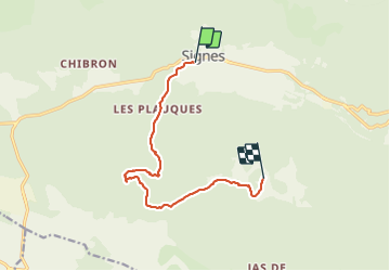
![](/images/other/stat-length.png)
![Trail Walking Signes - Signes défilé cote 709 - Photo](https://media.geolcdn.com/t/1900/400/bc39af4d-364a-47b1-bbe3-9f7dba354bb7.jpg&format=pjpeg&maxdim=2)
Signes défilé cote 709
chrifor
User
![Length](/images/other/stat-length.png)
![Max alt](https://static1.geolcdn.com/siteimages/upload/files/1508320355ic_sort_altitude_max_24dp.png)
![Uphill gradient](https://static1.geolcdn.com/siteimages/upload/files/1508320355ic_sort_den_pos_24dp.png)
![Km-Effort](/images/other/stat-length.png)
![Min alt](https://static1.geolcdn.com/siteimages/upload/files/1508320355ic_sort_altitude_min_24dp.png)
![Downhill gradient](https://static1.geolcdn.com/siteimages/upload/files/1508320355ic_sort_den_neg_24dp.png)
![Boucle](https://static1.geolcdn.com/siteimages/upload/files/16400158638029165_repeat_loop_refresh_sync_direction_icon.png)
![Walking](https://static1.geolcdn.com/sitytour/trail-icons/101.png)
3h10
Difficulty : Medium
![Scan this QR Code to open this trail in the SityTrail application](https://capi.geolives.com/qq0zvz2zws4bq2lad0pu/sitytour/trails/3194747/qr.png?size=200)
FREE GPS app for hiking
About
Trail Walking of 10.6 km to be discovered at Provence-Alpes-Côte d'Azur, Var, Signes. This trail is proposed by chrifor.
Description
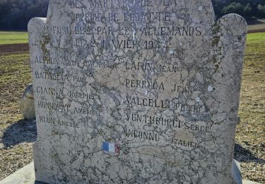
Panne de batterie!!! la rando (retour à Signes par le GR) affiche quelque 16km et 6OOm de denivelé. La descente par le GR est (longue et) très caillouteuse! A éviter par temps humide! L'intérêt de la rando, globalement très agréable, réside dans le défilé impressionnant, cote 709 pointe OUEST du parcours, mal rendu par les photos, la vue sur la baie de la Ciotat- St Cyr jusqu'au mont Puget (calanques) et sur le massif de la Ste Baume. 06/04/2022
Positioning
Comments
Trails nearby
![Trail Walking Signes - Chibron le Latay - Photo](https://media.geolcdn.com/t/375/260/e694ff95-44f1-4dc3-b2d8-47064715878f.jpg&format=jpg&maxdim=2)
![Walking Walking](https://static1.geolcdn.com/sitytour/trail-icons/101.png)
Walking
![](/images/other/stat-length.png)
![](https://static1.geolcdn.com/siteimages/upload/files/16400158638029165_repeat_loop_refresh_sync_direction_icon.png)
![Trail Mountain bike Signes - De Chibron à Riboux et au Grand Vallon, sur le versant sud de la Sainte Baume - Photo](https://media.geolcdn.com/t/375/260/ext.jpg?maxdim=2&url=https%3A%2F%2Fservices.sitytrail.com%2FGeolivesWS%2FDownloadMedia.ashx%3FTrailID%3D105192%26Media%3D8829_6.jpg)
![Mountain bike Mountain bike](https://static1.geolcdn.com/sitytour/trail-icons/202.png)
Mountain bike
![](/images/other/stat-length.png)
![](https://static1.geolcdn.com/siteimages/upload/files/16400158638029165_repeat_loop_refresh_sync_direction_icon.png)
![Trail Walking Signes - Signes - Vallon du Raby - Photo](https://media.geolcdn.com/t/375/260/ext.jpg?maxdim=2&url=https%3A%2F%2Fservices.sitytrail.com%2FGeolivesWS%2FDownloadMedia.ashx%3FTrailID%3D104111%26Media%3D7175_2.jpg)
![Walking Walking](https://static1.geolcdn.com/sitytour/trail-icons/101.png)
Walking
![](/images/other/stat-length.png)
![](https://static1.geolcdn.com/siteimages/upload/files/16400158638029165_repeat_loop_refresh_sync_direction_icon.png)
![Trail Walking Signes - grotte du mounoi signes - Photo](https://media.geolcdn.com/t/375/260/ext.jpg?maxdim=2&url=https%3A%2F%2Fservices.sitytrail.com%2FGeolivesWS%2FDownloadMedia.ashx%3FTrailID%3D266184%26Media%3Dfix__20140413111146.jpg)
![Walking Walking](https://static1.geolcdn.com/sitytour/trail-icons/101.png)
Walking
![](/images/other/stat-length.png)
![](https://static1.geolcdn.com/siteimages/upload/files/16400158638029165_repeat_loop_refresh_sync_direction_icon.png)
![Trail Mountain bike Signes - Le Mourré d'Agnis, itinéraire bis - Photo](https://media.geolcdn.com/t/375/260/ext.jpg?maxdim=2&url=https%3A%2F%2Fstatic1.geolcdn.com%2Fsiteimages%2Fupload%2Ffiles%2F1524743154velo.jpg)
![Mountain bike Mountain bike](https://static1.geolcdn.com/sitytour/trail-icons/202.png)
Mountain bike
![](/images/other/stat-length.png)
![](https://static1.geolcdn.com/siteimages/upload/files/16400158638029165_repeat_loop_refresh_sync_direction_icon.png)
![Trail Walking Signes - Colle de Fède, la Limate, Signes 09-10-2024 - Photo](https://media.geolcdn.com/t/375/260/b62999f6-c4a7-4930-a1fb-ab4a5e88e55d.jpg&format=jpg&maxdim=2)
![Walking Walking](https://static1.geolcdn.com/sitytour/trail-icons/101.png)
Walking
![](/images/other/stat-length.png)
![](https://static1.geolcdn.com/siteimages/upload/files/16400158638029165_repeat_loop_refresh_sync_direction_icon.png)
![Trail Walking Signes - Boucle Chibron - Haut Latay - Photo](https://media.geolcdn.com/t/375/260/771b5f19-68c5-4c25-a161-c2d323ea5609.jpg&format=jpg&maxdim=2)
![Walking Walking](https://static1.geolcdn.com/sitytour/trail-icons/101.png)
Walking
![](/images/other/stat-length.png)
![](https://static1.geolcdn.com/siteimages/upload/files/16400158638029165_repeat_loop_refresh_sync_direction_icon.png)
![Trail Walking Signes - Vallon des Martyrs Signes - Photo](https://media.geolcdn.com/t/375/260/b74b655a-455f-4f9a-a49a-c358cbcaa2a2.jpg&format=jpg&maxdim=2)
![Walking Walking](https://static1.geolcdn.com/sitytour/trail-icons/101.png)
Walking
![](/images/other/stat-length.png)
![](https://static1.geolcdn.com/siteimages/upload/files/16400158638029165_repeat_loop_refresh_sync_direction_icon.png)
![Trail Walking Signes - Montée vers le plateau de la Limatte en partant de Signes - Photo](https://media.geolcdn.com/t/375/260/926309de-1114-4042-85b2-8b324d33ac8a.jpg&format=jpg&maxdim=2)
![Walking Walking](https://static1.geolcdn.com/sitytour/trail-icons/101.png)
Walking
![](/images/other/stat-length.png)
![](https://static1.geolcdn.com/siteimages/upload/files/16400158638029165_repeat_loop_refresh_sync_direction_icon.png)