Trail Walking Lasalle - Boucle de la Chapelle de Sainte-Croix-de-Caldere - Photo

Boucle de la Chapelle de Sainte-Croix-de-Caldere

 ARVIEU
ARVIEU

User

© OpenStreetMap contributors
Length
Length
12.8 km
Max alt
Max alt
601 m
Uphill gradient
Uphill gradient
476 m
Km-Effort
Km-Effort  
19.1 km
Min alt
Min alt
213 m
Downhill gradient
Downhill gradient
479 m
Boucle
Boucle
Yes
Creation date :
2022-04-05 08:18:54.245
Updated on :
2022-04-05 08:22:39.059

(0 Reviews)

Walking
Walking
4h30
Difficulty : Medium

Scan this QR Code to open this trail in the SityTrail application

FREE GPS app for hiking

Logo SityTrail SityTrail

IGN / Geographical institutes

Download SityTrail from the App Store Download SityTrail from Google Play

Logo SityTrail SityTrail World

The world is yours!

Download SityTrail from the App Store Download SityTrail from Google Play Download SityTrail on Huawei AppGallery

About

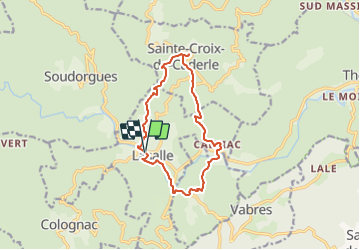
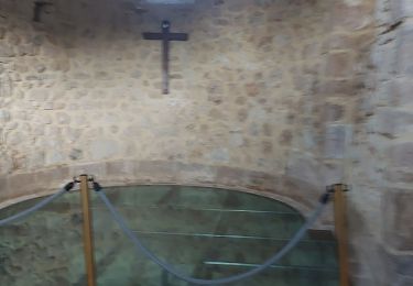
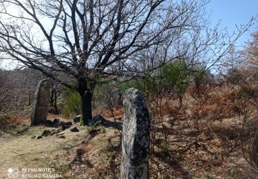
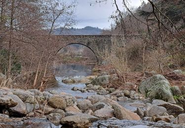
Trail Walking of 12.8 km to be discovered at Occitania, Gard, Lasalle. This trail is proposed by ARVIEU.

Description

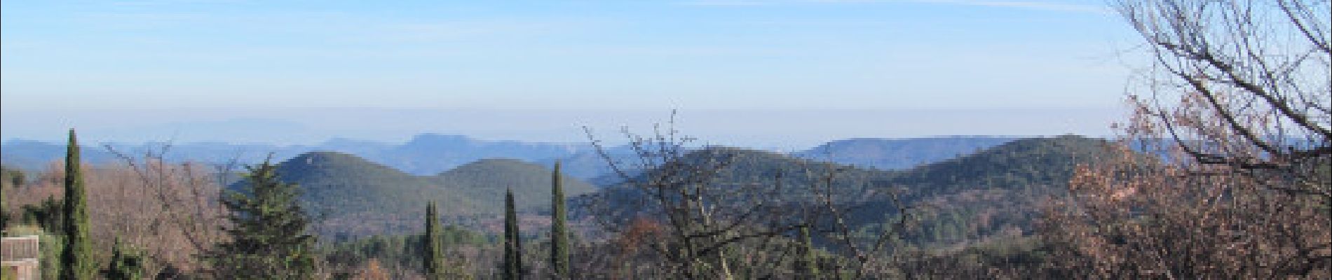
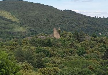
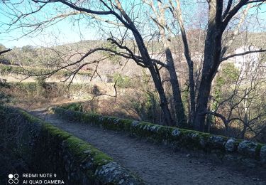
Boucle au départ du parking de la filature à Lasalle direction Sainte-Croix-de-Caldere et sa magnifique chapelle par le Col de l'Oursine. Retour par Calviac et Saint-Bonnet-de-Salendrinque. Principalement en sous-bois, vous aurez tout de même un bon nombre de points de vues magnifiques. À voir : Châteaux Le Sollier et Le Castellas, la chapelle de Sainte-Croix-de-Caldere, le Menhir à la Borie, la rivière la Salendrinque et les filatures de Lasalle.

Elevation profile

Photos

Points of interest

Point of interest Lasalle - Cimetiere - Photo
ARVIEU
LASALLE 
Point of interest Lasalle - Col de l'Oursine - Photo
ARVIEU
Point of interest Lasalle - vue direction Lasalle - Photo
ARVIEU
Point of interest Sainte-Croix-de-Caderle - Traversée de la route desservant Mas Hubert - Photo
ARVIEU
SAINTE-CROIX-DE-CADERLE 
Point of interest Sainte-Croix-de-Caderle - Sainte-Croix-de-Caderle - Photo
ARVIEU
SAINTE-CROIX-DE-CADERLE 
Point of interest Sainte-Croix-de-Caderle - Chapelle - Photo
ARVIEU
SAINTE-CROIX-DE-CADERLE 
Point of interest Sainte-Croix-de-Caderle - aire de pique nique eau potable - Photo
ARVIEU
SAINTE-CROIX-DE-CADERLE 
Point of interest Sainte-Croix-de-Caderle - La gare - Photo
ARVIEU
SAINTE-CROIX-DE-CADERLE 
Point of interest Lasalle - menhir - Photo
ARVIEU
LASALLE 
Point of interest Lasalle - La Coste - Photo
ARVIEU
LASALLE 
Point of interest Saint-Bonnet-de-Salendrinque - Sentier à gauche (panneau) - Photo
ARVIEU
SAINT-BONNET-DE-SALENDRINQUE 
Point of interest Saint-Bonnet-de-Salendrinque - La Chapelle - Photo
ARVIEU
SAINT-BONNET-DE-SALENDRINQUE 
Point of interest Saint-Bonnet-de-Salendrinque - Le Castellas - Photo
ARVIEU
SAINT-BONNET-DE-SALENDRINQUE 
Point of interest Lasalle - Boulangerie - Photo
ARVIEU
LASALLE 
Point of interest Lasalle - Jardins partagés - Photo
ARVIEU

Positioning

Country:
France
Region :
Occitania
Department/Province :
Gard
Municipality :
Lasalle
Location:
Unknown
Start:(UTM)
568232 ; 4877320 (31T) N.

Trails nearby

Trail Walking Soudorgues - Vallée Salindrenque - Photo
Walking
GUIDE
nadinebondoux

Walking

Difficult
Soudorgues, Occitania, Gard, France
19.4 km | 30 km-effort
6h 20min
Yes
Trail Walking Lasalle - LASALLE - SAINTE-CROIX-DE-CADERLE – CALVIAC - 8.3Km - 02h30 - Dénivelé 352 m - Photo
Walking
dansmabulle

Walking

Difficult
(1)
Lasalle, Occitania, Gard, France
12.8 km | 19.1 km-effort
3h 59min
Yes
Trail On foot Colognac - 30 du Cayrel au Camp Barrat 20/02/24 - Photo
On foot
silvestreclaudine

On foot

Medium
Colognac, Occitania, Gard, France
16 km | 25 km-effort
5h 38min
Yes
Trail Walking Lasalle - Lasalle  - Photo
Walking
GUIDE
Roger Philippe Wallez

Walking

Very difficult
Lasalle, Occitania, Gard, France
15.3 km | 22 km-effort
10h 52min
No
Trail Walking Lasalle - LaSalle  - Photo
Walking
GUIDE
Roger Philippe Wallez

Walking

Very difficult
Lasalle, Occitania, Gard, France
15.3 km | 22 km-effort
5h 31min
No
Trail Walking Lasalle - vallée Salindrenque autour de Lasalle  - Photo
Walking
GUIDE
nadinebondoux

Walking

Medium
Lasalle, Occitania, Gard, France
13.3 km | 19.7 km-effort
5h 9min
Yes
Trail Walking Lasalle - Lasalle Briontet Soudorgues - Photo
Walking
GUIDE
nadinebondoux

Walking

Difficult
Lasalle, Occitania, Gard, France
17.9 km | 29 km-effort
5h 32min
Yes
Trail Walking Lasalle - LaSalle - Photo
Walking
GUIDE
Roger Philippe Wallez

Walking

Very difficult
Lasalle, Occitania, Gard, France
18.8 km | 30 km-effort
6h 29min
No
Trail Walking Soudorgues - La Vallée Borgne - Photo
Walking
ARVIEU

Walking

Difficult
Soudorgues, Occitania, Gard, France
14.6 km | 22 km-effort
5h 30min
Yes


Close
My subscriptions