![](/images/other/stat-length.png)
![Trail Walking Dourbies - Lac des Pises 12 km - Photo](https://media.geolcdn.com/t/1900/400/ext.pjpeg?maxdim=2&url=https%3A%2F%2Fstatic1.geolcdn.com%2Fsiteimages%2Fupload%2Ffiles%2F1553511878bg_sport_marche.png)
Lac des Pises 12 km
randotines
User GUIDE
![Length](/images/other/stat-length.png)
![Max alt](https://static1.geolcdn.com/siteimages/upload/files/1508320355ic_sort_altitude_max_24dp.png)
![Uphill gradient](https://static1.geolcdn.com/siteimages/upload/files/1508320355ic_sort_den_pos_24dp.png)
![Km-Effort](/images/other/stat-length.png)
![Min alt](https://static1.geolcdn.com/siteimages/upload/files/1508320355ic_sort_altitude_min_24dp.png)
![Downhill gradient](https://static1.geolcdn.com/siteimages/upload/files/1508320355ic_sort_den_neg_24dp.png)
![Boucle](https://static1.geolcdn.com/siteimages/upload/files/16400158638029165_repeat_loop_refresh_sync_direction_icon.png)
![Walking](https://static1.geolcdn.com/sitytour/trail-icons/101.png)
3h24
Difficulty : Easy
![Scan this QR Code to open this trail in the SityTrail application](https://capi.geolives.com/qq0zvz2zws4bq2lad0pu/sitytour/trails/319164/qr.png?size=200)
FREE GPS app for hiking
About
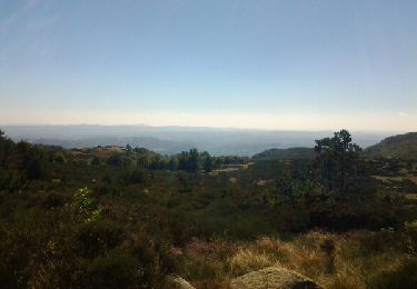
Trail Walking of 11.7 km to be discovered at Occitania, Gard, Dourbies. This trail is proposed by randotines.
Description
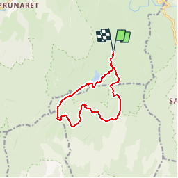
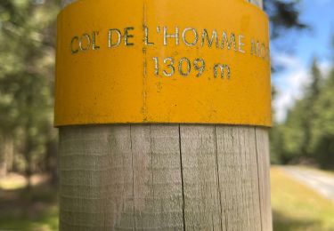
Sortie facile de 12 km au départ de la route forestière qui relie le col du Minier ( D 48 )au hameau du Prunaret ( gite d'étape du Mas Bresson )sur la D151c ( petit pont et table de pique-nique ). Prendre plein sud vers le lac des Pises, le longer par le sud puis monter vers le col des Pises puis presqu'au col de l'homme mort, bifurquer à gauche sur le Gr 66-71.Au col des Portes, quitter le GR et suivre le chemin de droite qui vous amène à la Baraque de Pialot.Prendre à droite et suivre le chemin plein nord qui vous ramène à votre point de départ.
Positioning
Comments
Trails nearby
![Trail Walking Arrigas - Col de l’Homme mort le Saint Guiral - Photo](https://media.geolcdn.com/t/375/260/261f46b4-fe0a-4f99-bec2-77703f139aba.jpg&format=jpg&maxdim=2)
![Walking Walking](https://static1.geolcdn.com/sitytour/trail-icons/101.png)
Walking
![](/images/other/stat-length.png)
![](https://static1.geolcdn.com/siteimages/upload/files/16400158638029165_repeat_loop_refresh_sync_direction_icon.png)
![Trail Walking Saint-Sauveur-Camprieu - Col du FAUBEL le Puey Barbut - Photo](https://media.geolcdn.com/t/375/260/98f69e29-1642-4fb5-a7e9-9dcbd06f1735.jpg&format=jpg&maxdim=2)
![Walking Walking](https://static1.geolcdn.com/sitytour/trail-icons/101.png)
Walking
![](/images/other/stat-length.png)
![](https://static1.geolcdn.com/siteimages/upload/files/16400158638029165_repeat_loop_refresh_sync_direction_icon.png)
![Trail Walking Val-d'Aigoual - L'Esperou Le Vigan GR 7 - Photo](https://media.geolcdn.com/t/375/260/46e8ebd9-240d-4741-8e1d-a008b70dff36.jpg&format=jpg&maxdim=2)
![Walking Walking](https://static1.geolcdn.com/sitytour/trail-icons/101.png)
Walking
![](/images/other/stat-length.png)
![](https://static1.geolcdn.com/siteimages/upload/files/16400158638029165_repeat_loop_refresh_sync_direction_icon.png)
![Walking Walking](https://static1.geolcdn.com/sitytour/trail-icons/101.png)
Walking
![](/images/other/stat-length.png)
![](https://static1.geolcdn.com/siteimages/upload/files/16400158638029165_repeat_loop_refresh_sync_direction_icon.png)
![Trail Walking Arphy - Cascade de l’Orgon - Photo](https://media.geolcdn.com/t/375/260/6c14b873-fecc-4339-a381-9e4910cd7e6f.jpg&format=jpg&maxdim=2)
![Walking Walking](https://static1.geolcdn.com/sitytour/trail-icons/101.png)
![Trail Walking Dourbies - saint sauveur de camprieu - Photo](https://media.geolcdn.com/t/375/260/96d89d7f-b0db-4cf2-aabf-9ad1eea76de1.jpg&format=jpg&maxdim=2)
![Walking Walking](https://static1.geolcdn.com/sitytour/trail-icons/101.png)
Walking
![](/images/other/stat-length.png)
![](https://static1.geolcdn.com/siteimages/upload/files/16400158638029165_repeat_loop_refresh_sync_direction_icon.png)
![Trail Walking Val-d'Aigoual - L’Esperou Dourbie 26 km - première étape tour de l'Aiguail en 3 jours - Photo](https://media.geolcdn.com/t/375/260/2e4ed44f-5a4c-4cf3-abfa-3ac78c38cb2d.jpg&format=jpg&maxdim=2)
![Walking Walking](https://static1.geolcdn.com/sitytour/trail-icons/101.png)
Walking
![](/images/other/stat-length.png)
![](https://static1.geolcdn.com/siteimages/upload/files/16400158638029165_repeat_loop_refresh_sync_direction_icon.png)
![Trail Walking Bréau-Mars - lac de pises - Photo](https://media.geolcdn.com/t/375/260/ext.jpg?maxdim=2&url=https%3A%2F%2Fservices.sitytrail.com%2FGeolivesWS%2FDownloadMedia.ashx%3FTrailID%3D344277%26Media%3Dfix__20140911144132.jpg)
![Walking Walking](https://static1.geolcdn.com/sitytour/trail-icons/101.png)
![Trail Walking Dourbies - Dourbies - Photo](https://media.geolcdn.com/t/375/260/ext.jpg?maxdim=2&url=https%3A%2F%2Fstatic1.geolcdn.com%2Fsiteimages%2Fupload%2Ffiles%2F1553511878bg_sport_marche.png)
![Walking Walking](https://static1.geolcdn.com/sitytour/trail-icons/101.png)
méribel