Trail Walking Aspères - Asperes-Clement-Gailhan-Lecques - Photo

Asperes-Clement-Gailhan-Lecques

 v.rabot
v.rabot

User

© OpenStreetMap contributors
Length
Length
18.1 km
Max alt
Max alt
112 m
Uphill gradient
Uphill gradient
260 m
Km-Effort
Km-Effort  
22 km
Min alt
Min alt
34 m
Downhill gradient
Downhill gradient
260 m
Boucle
Boucle
Yes
Creation date :
2022-04-03 07:48:27.891
Updated on :
2023-03-11 10:36:19.657

(0 Reviews)

Walking
Walking
5h00
Difficulty : Medium

Scan this QR Code to open this trail in the SityTrail application

FREE GPS app for hiking

Logo SityTrail SityTrail

IGN / Geographical institutes

Download SityTrail from the App Store Download SityTrail from Google Play

Logo SityTrail SityTrail World

The world is yours!

Download SityTrail from the App Store Download SityTrail from Google Play Download SityTrail on Huawei AppGallery

About

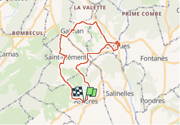
Trail Walking of 18.1 km to be discovered at Occitania, Gard, Aspères. This trail is proposed by v.rabot.

Description

Partant du parking d'Aspères, on passe sur le vieux cimetière d'Aspères complétement abandonné et on se dirige vers Saint Clément où on peut admirer un beau petit pont avec une table de pique-nique propice à la pause café, on admire au passage, la croix datant de 1765 avant de passer devant la mairie pour rejoindre Gailhan, où il y a aussi un petit parc ombragé, passage devant l'église du 11e siècle pour se diriger vers Lecques ou on trouvera aussi un parc ombragé avec deux tables de pique-niques pour la pause déjeuner, on pourra admirer la rénovation de l'ancienne cave coopérative, l'ancienne chapelle près de la mairie, on redescendra sur le vidourle  pour remonter sur l'église et passer dans quelques petites ruelles du village, pour reprendre la direction d'Aspères en passant près d'une source et en traversant un joli ruisseau (suivant la saison) pour faire la dernière montée du bois de Boulou, retour sur Aspères, passage devant l'église et la magnanerie, puis retour au parking. Les chemins sont généralement bons, les routes goudronnées n'avaient pas de circulation de véhicules. Aucune difficulté sur ce parcours

Elevation profile

Photos

27 photos in total. Please click on a photo to see them all in the gallery.

Positioning

Country:
France
Region :
Occitania
Department/Province :
Gard
Municipality :
Aspères
Location:
Unknown
Start:(UTM)
583677 ; 4851049 (31T) N.

Trails nearby

Trail Walking Fontanès - FONTANÉS 30 - SALINELLES - PONDRES - ballade autour du Vidourle  - Photo
Walking
jeff66

Walking

Medium
(3)
Fontanès, Occitania, Gard, France
10.7 km | 12.7 km-effort
1h 59min
Yes
Trail Walking Sommières -  SOMMIERES 30 - VILLEVIEILLE châteaux- JUNAS les carrières  - Photo
Walking
jeff66

Walking

Medium
(2)
Sommières, Occitania, Gard, France
14 km | 16.9 km-effort
2h 34min
Yes
Trail Walking Carnas - Carnas bois de Paris - Photo
Walking
CAMBON

Walking

Medium
(2)
Carnas, Occitania, Gard, France
12.8 km | 15.6 km-effort
4h 0min
Yes
Trail Walking Saint-Clément - Le bois de Paris - Grotte, Table d'orientation, Oppidum - Photo
Walking
f4tnk

Walking

Medium
(1)
Saint-Clément, Occitania, Gard, France
8.2 km | 10.9 km-effort
2h 29min
Yes
Trail Walking Sommières - Autour de Villevielle 30 - Photo
Walking
guignier

Walking

Easy
(2)
Sommières, Occitania, Gard, France
10.5 km | 12.3 km-effort
3h 0min
Yes
Trail Walking Salinelles - salinelles-pondres-souvignargues-fontanes - Photo
Walking
v.rabot

Walking

Medium
Salinelles, Occitania, Gard, France
14.7 km | 17.2 km-effort
4h 14min
Yes
Trail Walking Sommières - Les matches de géants  - Photo
Walking
gscholasch

Walking

Easy
Sommières, Occitania, Gard, France
48 km | 67 km-effort
3h 29min
No
Trail Walking Aspères - Aspères - Photo
Walking
GUIDE
Roger Philippe Wallez

Walking

Difficult
Aspères, Occitania, Gard, France
12.6 km | 16.4 km-effort
4h 26min
Yes
Trail Walking Saussines - Saussines et ses capitelles - Photo
Walking
v.rabot

Walking

Medium
Saussines, Occitania, Hérault, France
10.3 km | 11.6 km-effort
2h 37min
Yes


Close
My subscriptions