Pic Melette
Marco05
User GUIDE
Length
9.8 km
Max alt
2042 m
Uphill gradient
907 m
Km-Effort
22 km
Min alt
1176 m
Downhill gradient
908 m
Boucle
Yes
Creation date :
2022-04-01 12:02:48.374
Updated on :
2022-11-29 13:04:44.024
4h59
Difficulty : Difficult
FREE GPS app for hiking
About
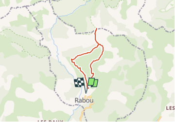
Trail Walking of 9.8 km to be discovered at Provence-Alpes-Côte d'Azur, Hautes-Alpes, Rabou. This trail is proposed by Marco05.
Description
Sommet au départ de Rabou à l'ouest de Gap.
C'est une jolie boucle qui empreint le fameux sentier des Bans.
Dans ce passage attention au vertige.
Pas de difficulté technique.
Le final, assez pentu, se fait à vue sans aucun problème.
Positioning
Country:
France
Region :
Provence-Alpes-Côte d'Azur
Department/Province :
Hautes-Alpes
Municipality :
Rabou
Location:
Unknown
Start:(Dec)
Start:(UTM)
262420 ; 4942217 (32T) N.
Comments
Trails nearby
Brèche et croix de Charance
Walking
Easy
(1)
Gap,
Provence-Alpes-Côte d'Azur,
Hautes-Alpes,
France
8.6 km | 18.5 km-effort
2h 13min
No
Rabou Tour du Puy
Walking
Medium
Rabou,
Provence-Alpes-Côte d'Azur,
Hautes-Alpes,
France
11.5 km | 21 km-effort
4h 46min
Yes
Pic de Charance
Walking
Medium
Gap,
Provence-Alpes-Côte d'Azur,
Hautes-Alpes,
France
8.9 km | 19 km-effort
4h 18min
Yes
Pic de Gleize
Walking
Medium
Gap,
Provence-Alpes-Côte d'Azur,
Hautes-Alpes,
France
4.8 km | 10.6 km-effort
2h 25min
Yes
Cuchon-Pic de Charance
Walking
Difficult
Gap,
Provence-Alpes-Côte d'Azur,
Hautes-Alpes,
France
12.3 km | 24 km-effort
5h 32min
Yes
Col de Guizière
Walking
Medium
Gap,
Provence-Alpes-Côte d'Azur,
Hautes-Alpes,
France
8.7 km | 17.5 km-effort
3h 58min
Yes
7 Chemin GAP - LA MOTTE DU CAIRE
Walking
Very difficult
Gap,
Provence-Alpes-Côte d'Azur,
Hautes-Alpes,
France
41 km | 60 km-effort
11h 0min
No
La Rivière
Mountain bike
Difficult
La Roche-des-Arnauds,
Provence-Alpes-Côte d'Azur,
Hautes-Alpes,
France
38 km | 54 km-effort
2h 31min
Yes
9587041
On foot
Easy
Rabou,
Provence-Alpes-Côte d'Azur,
Hautes-Alpes,
France
6.6 km | 10.6 km-effort
3h 56min
No