Trail Walking Veynes - Champérus - Photo
 Marco05
Marco05

User GUIDE

© OpenStreetMap contributors
Length
Length
5 km
Max alt
Max alt
1211 m
Uphill gradient
Uphill gradient
409 m
Km-Effort
Km-Effort  
10.5 km
Min alt
Min alt
838 m
Downhill gradient
Downhill gradient
408 m
Boucle
Boucle
Yes
Creation date :
2022-04-01 12:00:27.33
Updated on :
2022-08-13 12:19:12.806

(0 Reviews)

Walking
Walking
2h23
Difficulty : Medium

Scan this QR Code to open this trail in the SityTrail application

FREE GPS app for hiking

Logo SityTrail SityTrail

IGN / Geographical institutes

Download SityTrail from the App Store Download SityTrail from Google Play

Logo SityTrail SityTrail World

The world is yours!

Download SityTrail from the App Store Download SityTrail from Google Play Download SityTrail on Huawei AppGallery

About

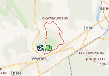
Trail Walking of 5 km to be discovered at Provence-Alpes-Côte d'Azur, Hautes-Alpes, Veynes. This trail is proposed by Marco05.

Description

Randonnée de difficulté moyenne au départ de la commune de Veynes.
Il est impotant de la faire dans le sens que j'ai indiqué, car ce côté est assez pentu, et le descendre est une vrai épreuve.
Donc, à faire dans le sens horaire.
En arrivant 100 mètres sous le sommet, il y a un cable sur votre gauche pour aider dans le final.
La descente côté Chateauvieux ne présente aucune difficulté.

Elevation profile

Photos

Positioning

Country:
France
Region :
Provence-Alpes-Côte d'Azur
Department/Province :
Hautes-Alpes
Municipality :
Veynes
Location:
Unknown
Start:(UTM)
724653 ; 4935330 (31T) N.

Trails nearby

Trail Walking Montmaur - Montmaur Le Terrail - Photo
Walking
GUIDE
Marco05

Walking

Easy
(1)
Montmaur, Provence-Alpes-Côte d'Azur, Hautes-Alpes, France
5.3 km | 6.2 km-effort
1h 22min
Yes
Trail Walking Veynes - Charajaille - Photo
Walking
GUIDE
Marco05

Walking

Difficult
(1)
Veynes, Provence-Alpes-Côte d'Azur, Hautes-Alpes, France
8.1 km | 16.2 km-effort
3h 41min
Yes
Trail Mountain bike Veynes - VTT29 - Rando famille - Photo
Mountain bike
GUIDE+

Mountain bike

Easy
(1)
Veynes, Provence-Alpes-Côte d'Azur, Hautes-Alpes, France
10.9 km | 13.6 km-effort
54min
Yes
Trail Mountain bike Veynes - VTT14 - Les crêtes de la Longeagne - Photo
Mountain bike
GUIDE+

Mountain bike

Very difficult
(1)
Veynes, Provence-Alpes-Côte d'Azur, Hautes-Alpes, France
39 km | 57 km-effort
3h 15min
Yes
Trail Mountain bike Veynes - VTT03 - Tous les Eygaux - Photo
Mountain bike
GUIDE+

Mountain bike

Medium
(2)
Veynes, Provence-Alpes-Côte d'Azur, Hautes-Alpes, France
23 km | 31 km-effort
1h 31min
Yes
Trail Mountain bike Veynes - VTT02 - Aiguebelle - Photo
Mountain bike
GUIDE+

Mountain bike

Easy
(2)
Veynes, Provence-Alpes-Côte d'Azur, Hautes-Alpes, France
16.7 km | 21 km-effort
1h 23min
Yes
Trail Mountain bike Veynes - VTT01 - Les Eygaux - Photo
Mountain bike
GUIDE+

Mountain bike

Easy
(3)
Veynes, Provence-Alpes-Côte d'Azur, Hautes-Alpes, France
14.1 km | 19.2 km-effort
1h 13min
Yes
Trail Walking Veynes - R10   Le tour des Eygaux - Photo
Walking
GUIDE+

Walking

Very easy
(4)
Veynes, Provence-Alpes-Côte d'Azur, Hautes-Alpes, France
7.8 km | 11.3 km-effort
2h 24min
Yes
Trail Walking Veynes - R09   Le tour de Veynes - Photo
Walking
GUIDE+

Walking

Very easy
(3)
Veynes, Provence-Alpes-Côte d'Azur, Hautes-Alpes, France
9.5 km | 12.3 km-effort
2h 40min
Yes


Close
My subscriptions