Trail Nordic walking Réallon - Réallon fort de Reallon Chantal - Photo

Réallon fort de Reallon Chantal

 damlou
damlou

User

© OpenStreetMap contributors
Length
Length
6.2 km
Max alt
Max alt
1587 m
Uphill gradient
Uphill gradient
284 m
Km-Effort
Km-Effort  
10.1 km
Min alt
Min alt
1322 m
Downhill gradient
Downhill gradient
302 m
Boucle
Boucle
No
Creation date :
2022-04-01 07:34:43.561
Updated on :
2022-04-01 10:13:24.452

(1 Reviews)

Nordic walking
Nordic walking
1h53
Difficulty : Medium

Scan this QR Code to open this trail in the SityTrail application

FREE GPS app for hiking

Logo SityTrail SityTrail

IGN / Geographical institutes

Download SityTrail from the App Store Download SityTrail from Google Play

Logo SityTrail SityTrail World

The world is yours!

Download SityTrail from the App Store Download SityTrail from Google Play Download SityTrail on Huawei AppGallery

About

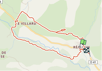
Trail Nordic walking of 6.2 km to be discovered at Provence-Alpes-Côte d'Azur, Hautes-Alpes, Réallon. This trail is proposed by damlou.

Description

Montée jusqu'au fort puis descente vers nationale
Traversée forêt le long pisre ski fond du canal à plat.
Petite montée jusqu'au voitures

Elevation profile

Positioning

Country:
France
Region :
Provence-Alpes-Côte d'Azur
Department/Province :
Hautes-Alpes
Municipality :
Réallon
Location:
Unknown
Start:(UTM)
290756 ; 4941400 (32T) N.

Comments

Please log in to post a review or rate the element


Trails nearby

Trail Walking Réallon - AIguilles de Chabrieres au départ de la Station de ski Reallon - Photo
Walking
Maca8284

Walking

Very difficult
(1)
Réallon, Provence-Alpes-Côte d'Azur, Hautes-Alpes, France
14 km | 25 km-effort
6h 0min
Yes
Trail Walking Réallon - Aiguilles de Chabrière - Photo
Walking
GUIDE
David25400

Walking

Easy
(1)
Réallon, Provence-Alpes-Côte d'Azur, Hautes-Alpes, France
12.2 km | 23 km-effort
5h 35min
Yes
Trail Walking Réallon - le fort de Réallon - Photo
Walking
gildascb

Walking

Very easy
(1)
Réallon, Provence-Alpes-Côte d'Azur, Hautes-Alpes, France
8 km | 11.8 km-effort
2h 11min
Yes
Trail Walking Puy-Saint-Eusèbe - canal de reyssas jusqu'aux Touisses / retour par le GR Serre-Ponçon via ravin de la pisse  - Photo
Walking
GUIDE
stef789

Walking

Medium
Puy-Saint-Eusèbe, Provence-Alpes-Côte d'Azur, Hautes-Alpes, France
9.7 km | 15.4 km-effort
4h 51min
Yes
Trail Walking Réallon - SityTrail - 2556786 - aiguilles-de-chabriere - Photo
Walking
GUIDE
amiral13

Walking

Difficult
Réallon, Provence-Alpes-Côte d'Azur, Hautes-Alpes, France
11.8 km | 23 km-effort
6h 0min
Yes
Trail Snowshoes Réallon - Raquettes Réallon  - Photo
Snowshoes
GUIDE
David25400

Snowshoes

Easy
Réallon, Provence-Alpes-Côte d'Azur, Hautes-Alpes, France
6.5 km | 14.3 km-effort
3h 27min
Yes
Trail Walking Réallon - Reallon-Serre du Mouton 7km - Photo
Walking
GUIDE
thonyc

Walking

Easy
Réallon, Provence-Alpes-Côte d'Azur, Hautes-Alpes, France
7.3 km | 13 km-effort
2h 53min
Yes
Trail Walking Saint-Apollinaire - Aiguilles Chabrieres 08/08/18 - Photo
Walking
GUIDE
R@ph

Walking

Medium
Saint-Apollinaire, Provence-Alpes-Côte d'Azur, Hautes-Alpes, France
11 km | 24 km-effort
4h 42min
Yes
Trail Walking Réallon - Embrunais - Réallon Le Fort - 3.2km 200m 1h10 - 2018 06 28 - public - Photo
Walking
GUIDE
Orcal37

Walking

Very easy
Réallon, Provence-Alpes-Côte d'Azur, Hautes-Alpes, France
3.1 km | 5.7 km-effort
1h 20min
Yes


Close
My subscriptions