![](/images/other/stat-length.png)
![Trail Walking Mouans-Sartoux - Canal de la Siagne par les Gipières et le bas Saurin - Photo](https://media.geolcdn.com/t/1900/400/ext.pjpeg?maxdim=2&url=https%3A%2F%2Fstatic1.geolcdn.com%2Fsiteimages%2Fupload%2Ffiles%2F1553511878bg_sport_marche.png)
Canal de la Siagne par les Gipières et le bas Saurin
alainfauvet
User
![Length](/images/other/stat-length.png)
![Max alt](https://static1.geolcdn.com/siteimages/upload/files/1508320355ic_sort_altitude_max_24dp.png)
![Uphill gradient](https://static1.geolcdn.com/siteimages/upload/files/1508320355ic_sort_den_pos_24dp.png)
![Km-Effort](/images/other/stat-length.png)
![Min alt](https://static1.geolcdn.com/siteimages/upload/files/1508320355ic_sort_altitude_min_24dp.png)
![Downhill gradient](https://static1.geolcdn.com/siteimages/upload/files/1508320355ic_sort_den_neg_24dp.png)
![Boucle](https://static1.geolcdn.com/siteimages/upload/files/16400158638029165_repeat_loop_refresh_sync_direction_icon.png)
![Walking](https://static1.geolcdn.com/sitytour/trail-icons/101.png)
1h09
Difficulty : Easy
![Scan this QR Code to open this trail in the SityTrail application](https://capi.geolives.com/qq0zvz2zws4bq2lad0pu/sitytour/trails/3185295/qr.png?size=200)
FREE GPS app for hiking
About
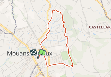
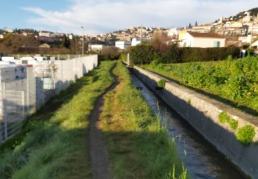
Trail Walking of 4.1 km to be discovered at Provence-Alpes-Côte d'Azur, Maritime Alps, Mouans-Sartoux. This trail is proposed by alainfauvet.
Description
Départ de la salle Léo Lagrange- longer l'école Aimé Legall jusqu'à la gare- prendre le passage souterrain- longer la voie ferrée en direction de Plascassier par la corniche Paul Bénard- à 80m prendre à droite le chemin des 2 vallons (en impasse), passer par la chicane piéton à gauche et poursuivre sur la 2ème partie du chemin des vallons- prendre à gauche le chemin de Bellon- prendre à droite le passage piéton le long de la corniche Paul Bénard- prendre à droite le chemin des Gipières en montée jusqu'au canal de la Siagne- prendre à droite le canal de la Siagne en direction de Mougins- poursuivre sur le canal de la Siagne en passant une successivement une voie privée puis l'avenue des Sources- redescendre par le chemin de Saurin (GR 670 A chemin de Compostelle)- en bas du chemin de Saurin poursuivre en face et rejoindre à droite l'allée piétonne qui longe la voie ferrée- la suivre jusqu'au passage souterrain de la gare et rejoindre la salle Léo Lagrange
Positioning
Comments
Trails nearby
![Trail On foot Valbonne - Circuit du Bruguet - Photo](https://media.geolcdn.com/t/375/260/68fef880-5161-4eed-ba0f-265464725084.jpeg&format=jpg&maxdim=2)
![On foot On foot](https://static1.geolcdn.com/sitytour/trail-icons/100.png)
On foot
![](/images/other/stat-length.png)
![](https://static1.geolcdn.com/siteimages/upload/files/16400158638029165_repeat_loop_refresh_sync_direction_icon.png)
![Trail Walking Le Cannet - Sur les pas de Bonnard, Le Cannet - Photo](https://media.geolcdn.com/t/375/260/912049f5-6832-4114-95a4-305d08e71f05.jpg&format=jpg&maxdim=2)
![Walking Walking](https://static1.geolcdn.com/sitytour/trail-icons/101.png)
Walking
![](/images/other/stat-length.png)
![](https://static1.geolcdn.com/siteimages/upload/files/16400158638029165_repeat_loop_refresh_sync_direction_icon.png)
![Trail sport Mougins - Le long du canal de la Siagne (une partie) - Photo](https://media.geolcdn.com/t/375/260/4d0c3f2a-5e8d-470f-a038-a129b60e8cd6.jpg&format=jpg&maxdim=2)
sport
![](/images/other/stat-length.png)
![](https://static1.geolcdn.com/siteimages/upload/files/16400158638029165_repeat_loop_refresh_sync_direction_icon.png)
![Trail Walking Grasse - Cul de sac - Photo](https://media.geolcdn.com/t/375/260/63181250-d399-4253-8f13-ebdec91b9f4d.jpg&format=jpg&maxdim=2)
![Walking Walking](https://static1.geolcdn.com/sitytour/trail-icons/101.png)
Walking
![](/images/other/stat-length.png)
![](https://static1.geolcdn.com/siteimages/upload/files/16400158638029165_repeat_loop_refresh_sync_direction_icon.png)
![Trail Walking Pégomas - Mimosa Pégomas - Photo](https://media.geolcdn.com/t/375/260/85714f43-aefd-4baa-a294-c47311edf4b3.jpg&format=jpg&maxdim=2)
![Walking Walking](https://static1.geolcdn.com/sitytour/trail-icons/101.png)
Walking
![](/images/other/stat-length.png)
![](https://static1.geolcdn.com/siteimages/upload/files/16400158638029165_repeat_loop_refresh_sync_direction_icon.png)
![Trail Mountain bike La Roquette-sur-Siagne - La Roquette-sur-Siagne - Col Notre Dame (326m) - Photo](https://media.geolcdn.com/t/375/260/ext.jpg?maxdim=2&url=https%3A%2F%2Fstatic1.geolcdn.com%2Fsiteimages%2Fupload%2Ffiles%2F1524743154velo.jpg)
![Mountain bike Mountain bike](https://static1.geolcdn.com/sitytour/trail-icons/202.png)
Mountain bike
![](/images/other/stat-length.png)
![](https://static1.geolcdn.com/siteimages/upload/files/16400158638029165_repeat_loop_refresh_sync_direction_icon.png)
![Trail Walking Grasse - 20190517. Grasse, le centre historique à pied. - Photo](https://media.geolcdn.com/t/375/260/34decc08-7b67-471b-923a-bfd31c4521ab.jpg&format=jpg&maxdim=2)
![Walking Walking](https://static1.geolcdn.com/sitytour/trail-icons/101.png)
Walking
![](/images/other/stat-length.png)
![](https://static1.geolcdn.com/siteimages/upload/files/16400158638029165_repeat_loop_refresh_sync_direction_icon.png)
![Trail Walking Pégomas - test. - Photo](https://media.geolcdn.com/t/375/260/1bdae25c-cba0-400c-946d-4b99878116b8.jpg&format=jpg&maxdim=2)
![Walking Walking](https://static1.geolcdn.com/sitytour/trail-icons/101.png)
Walking
![](/images/other/stat-length.png)
![](https://static1.geolcdn.com/siteimages/upload/files/16400158638029165_repeat_loop_refresh_sync_direction_icon.png)
![Trail Walking Pégomas - Pégomas - Circuit des Mimosas - Photo](https://media.geolcdn.com/t/375/260/ext.jpg?maxdim=2&url=https%3A%2F%2Fservices.sitytrail.com%2FGeolivesWS%2FDownloadMedia.ashx%3FTrailID%3D1106929%26Media%3Dfix__20190206102608.jpg)
![Walking Walking](https://static1.geolcdn.com/sitytour/trail-icons/101.png)
Walking
![](/images/other/stat-length.png)
![](https://static1.geolcdn.com/siteimages/upload/files/16400158638029165_repeat_loop_refresh_sync_direction_icon.png)