Trail Walking Grafenhausen - circuit de Staufen - Photo
© OpenStreetMap contributors
Length
Length
13.4 km
Max alt
Max alt
958 m
Uphill gradient
Uphill gradient
483 m
Km-Effort
Km-Effort  
19.8 km
Min alt
Min alt
636 m
Downhill gradient
Downhill gradient
483 m
Boucle
Boucle
Yes
Creation date :
2022-03-28 18:57:08.317
Updated on :
2022-03-28 18:57:13.65

(1 Reviews)

Walking
Walking
4h29
Difficulty : Medium

Scan this QR Code to open this trail in the SityTrail application

FREE GPS app for hiking

Logo SityTrail SityTrail

IGN / Geographical institutes

Download SityTrail from the App Store Download SityTrail from Google Play

Logo SityTrail SityTrail World

The world is yours!

Download SityTrail from the App Store Download SityTrail from Google Play Download SityTrail on Huawei AppGallery

About

Trail Walking of 13.4 km to be discovered at Baden-Württemberg, Landkreis Waldshut, Grafenhausen. This trail is proposed by moniquebvin.

Elevation profile

Positioning

Country:
Germany
Region :
Baden-Württemberg
Department/Province :
Landkreis Waldshut
Municipality :
Grafenhausen
Location:
Unknown
Start:(UTM)
440893 ; 5289540 (32T) N.

Comments

Please log in to post a review or rate the element


superbe mais à effectuer dans le sens inverse pour éviter une descente assez dangereuse, moins en montée. Déconseillé cependant aux débutants et personnes sujettes au vertige car passages en corniche sur rochers et montées assez raides sur plusieurs centaines de mètres


Trails nearby

Trail On foot Grafenhausen - Rappenfelsensteig - Photo
On foot
GUIDE+

On foot

Easy
Grafenhausen, Baden-Württemberg, Landkreis Waldshut, Germany
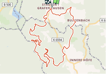
12.7 km | 18.9 km-effort
4h 17min
Yes
Trail On foot Höchenschwand - Dreihäusleweiher-Tour - Photo
On foot
GUIDE+

On foot

Easy
Höchenschwand, Baden-Württemberg, Landkreis Waldshut, Germany
3.1 km | 4.8 km-effort
1h 5min
No
Trail Via ferrata Schluchsee - 15 Velo um den Schluchsee - Photo
Via ferrata
kurt

Via ferrata

Very easy
Schluchsee, Baden-Württemberg, Landkreis Breisgau-Hochschwarzwald, Germany
20 km | 28 km-effort
Unknown
Yes
Trail Walking Höchenschwand - vers Albstausee - Photo
Walking
moniquebvin

Walking

Medium
(1)
Höchenschwand, Baden-Württemberg, Landkreis Waldshut, Germany
14.5 km | 23 km-effort
5h 7min
Yes
Trail Walking Höchenschwand - TK5 amélioré Hochenschwand  - Photo
Walking
moniquebvin

Walking

Medium
(1)
Höchenschwand, Baden-Württemberg, Landkreis Waldshut, Germany
16.7 km | 23 km-effort
5h 16min
Yes
Trail Walking Höchenschwand - TK6 Hochenschwand  - Photo
Walking
moniquebvin

Walking

Medium
(1)
Höchenschwand, Baden-Württemberg, Landkreis Waldshut, Germany
15.8 km | 22 km-effort
4h 56min
Yes


Close
My subscriptions