Trail Mountain bike Bazaiges - bazaiges gargilesse 34 kms D+ 600 - Photo

bazaiges gargilesse 34 kms D+ 600

 mib65
mib65

User

© OpenStreetMap contributors
Length
Length
34 km
Max alt
Max alt
273 m
Uphill gradient
Uphill gradient
599 m
Km-Effort
Km-Effort  
42 km
Min alt
Min alt
124 m
Downhill gradient
Downhill gradient
599 m
Boucle
Boucle
Yes
Creation date :
2022-03-25 16:12:18.007
Updated on :
2022-03-25 16:13:25.251

(0 Reviews)

Mountain bike
Mountain bike
2h54
Difficulty : Very difficult

Scan this QR Code to open this trail in the SityTrail application

FREE GPS app for hiking

Logo SityTrail SityTrail

IGN / Geographical institutes

Download SityTrail from the App Store Download SityTrail from Google Play

Logo SityTrail SityTrail World

The world is yours!

Download SityTrail from the App Store Download SityTrail from Google Play Download SityTrail on Huawei AppGallery

About

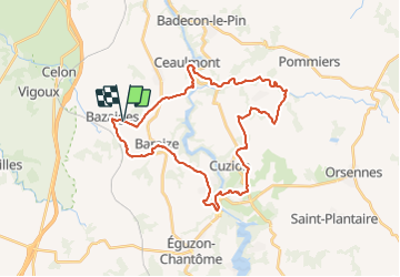
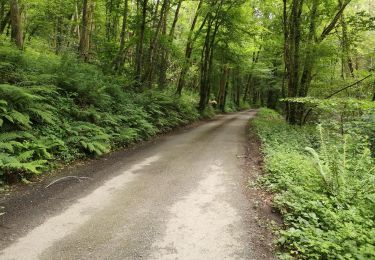
Trail Mountain bike of 34 km to be discovered at Centre-Loire Valley, Indre, Bazaiges. This trail is proposed by mib65.

Elevation profile

Positioning

Country:
France
Region :
Centre-Loire Valley
Department/Province :
Indre
Municipality :
Bazaiges
Location:
Unknown
Start:(UTM)
388061 ; 5150399 (31T) N.

Trails nearby

Trail Walking Gargilesse-Dampierre - SityTrail - La Chaumerette,Gargilesse - Photo
Walking
GUIDE
jeanmarcMasson

Walking

Very difficult
(1)
Gargilesse-Dampierre, Centre-Loire Valley, Indre, France
15.8 km | 19.7 km-effort
4h 28min
Yes
Trail Walking Cuzion - Eguzon - Circuit J2 30 km - Photo
Walking
GUIDE
chessyca

Walking

Difficult
Cuzion, Centre-Loire Valley, Indre, France
30 km | 40 km-effort
6h 46min
Yes
Trail Walking Cuzion - eguzon fete de la chataigne j 1 - Photo
Walking
GUIDE
chessyca

Walking

Difficult
Cuzion, Centre-Loire Valley, Indre, France
28 km | 36 km-effort
6h 30min
Yes
Trail Walking Gargilesse-Dampierre - Compostelle etape 13 - Photo
Walking
maginot

Walking

Difficult
Gargilesse-Dampierre, Centre-Loire Valley, Indre, France
29 km | 39 km-effort
9h 58min
No
Trail Walking Gargilesse-Dampierre - Beau parcours au départ du moulin de Gargilesse - Photo
Walking
Ecureuiltrailer

Walking

Very easy
Gargilesse-Dampierre, Centre-Loire Valley, Indre, France
16.2 km | 21 km-effort
3h 48min
Yes
Trail Walking Cuzion - Pont des Piles - Crozant - Photo
Walking
tracegps

Walking

Medium
Cuzion, Centre-Loire Valley, Indre, France
29 km | 38 km-effort
7h 0min
Yes
Trail Walking Cuzion - la passerelle de casse cou  - Photo
Walking
jouhan

Walking

Easy
(1)
Cuzion, Centre-Loire Valley, Indre, France
3.2 km | 4.3 km-effort
1h 10min
Yes
Trail Walking Gargilesse-Dampierre - La chaumerette pont des piles - Photo
Walking
marianne guichoux

Walking

Difficult
Gargilesse-Dampierre, Centre-Loire Valley, Indre, France
22 km | 27 km-effort
5h 28min
Yes
Trail Walking Baraize - Montcocu par la passerelle himalayenne - Photo
Walking
nicolashe24

Walking

Medium
Baraize, Centre-Loire Valley, Indre, France
4.5 km | 6 km-effort
1h 21min
Yes


Close
My subscriptions