![](/images/other/stat-length.png)
![Trail Walking Sailly-sur-la-Lys - Chemin Champêtre - Sailly sur la Lys - Photo](https://media.geolcdn.com/t/1900/400/ext.pjpeg?maxdim=2&url=https%3A%2F%2Fservices.sitytrail.com%2FGeolivesWS%2FDownloadMedia.ashx%3FTrailID%3D318007%26Media%3D17461_6.jpg)
Chemin Champêtre - Sailly sur la Lys
tracegps
User
![Length](/images/other/stat-length.png)
![Max alt](https://static1.geolcdn.com/siteimages/upload/files/1508320355ic_sort_altitude_max_24dp.png)
![Uphill gradient](https://static1.geolcdn.com/siteimages/upload/files/1508320355ic_sort_den_pos_24dp.png)
![Km-Effort](/images/other/stat-length.png)
![Min alt](https://static1.geolcdn.com/siteimages/upload/files/1508320355ic_sort_altitude_min_24dp.png)
![Downhill gradient](https://static1.geolcdn.com/siteimages/upload/files/1508320355ic_sort_den_neg_24dp.png)
![Boucle](https://static1.geolcdn.com/siteimages/upload/files/16400158638029165_repeat_loop_refresh_sync_direction_icon.png)
![Walking](https://static1.geolcdn.com/sitytour/trail-icons/101.png)
2h30
Difficulty : Medium
![Scan this QR Code to open this trail in the SityTrail application](https://capi.geolives.com/qq0zvz2zws4bq2lad0pu/sitytour/trails/318007/qr.png?size=200)
FREE GPS app for hiking
About
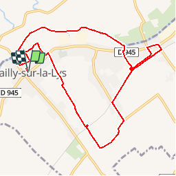
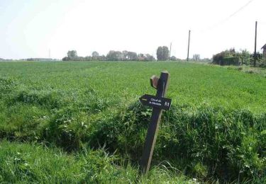
Trail Walking of 9.7 km to be discovered at Hauts-de-France, Pas-de-Calais, Sailly-sur-la-Lys. This trail is proposed by tracegps.
Description
Circuit proposé par la commune de Sailly-sur-la-Lys et l’Association des Randonneurs de l’Alloeu de Sailly sur la Lys. Départ place de la Mairie. Prendre la ruelle Delattre puis rejoindre la résidence du Clos de La Prévôté. Prendre à gauche (derrière le cimetière), le Chemin du Prévôt pour rejoindre la rue Gustave Eiffel, puis la rue Jean Monnet jusqu’à la rue de la Lys. Traverser la rue de la Lys puis prendre à gauche jusque la rue des Chauds Fourneaux que l’on prend jusqu’au bout. Prendre (à gauche) la rue Bataille jusque la rue de Bruges (à droite) que l’on emprunte jusqu’au passage à niveau. Prendre (à droite), le chemin rural jusque la rue Ervins que l’on prend à gauche jusque la rue de la Lys. Prendre (à gauche) jusque la rue de la gare (1). Au bout, à droite, longer jusque la Briqueterie. A la Briqueterie rejoindre la rue de la Lys. Prendre le chemin (à gauche de la Chapelle) vers l’écluse. Prendre alors le chemin de la Lys jusque la halte-nautique que vous quittez (2) à gauche par la rue de l’Eglise pour rejoindre la place de l’Eglise. Prendre l’allée des Tilleuls puis la ruelle Delattre pour rejoindre la place de la Mairie. (1) possibilité de rejoindre Steenwerck ou Erquinghem/Lys par les berges de la Lys après le pont (2): en prenant le pont, possibilité de rejoindre Steenwerck ou Estaires. Retrouvez le descriptif et le plan sur le site de la commune de Sailly-sur-la-Lys.
Positioning
Comments
Trails nearby
![Trail Walking La Gorgue - Chemin de randonnée des Magots (Version longue) - La Gorgue - Photo](https://media.geolcdn.com/t/375/260/ext.jpg?maxdim=2&url=https%3A%2F%2Fservices.sitytrail.com%2FGeolivesWS%2FDownloadMedia.ashx%3FTrailID%3D129826%26Media%3D13377_5.jpg)
![Walking Walking](https://static1.geolcdn.com/sitytour/trail-icons/101.png)
Walking
![](/images/other/stat-length.png)
![](https://static1.geolcdn.com/siteimages/upload/files/16400158638029165_repeat_loop_refresh_sync_direction_icon.png)
![Trail On foot Sailly-sur-la-Lys - Chemin Champêtre - Photo](https://media.geolcdn.com/t/375/260/08a11db1-c43e-4c4d-8e74-bd4badb13341.jpeg&format=jpg&maxdim=2)
![On foot On foot](https://static1.geolcdn.com/sitytour/trail-icons/100.png)
On foot
![](/images/other/stat-length.png)
![](https://static1.geolcdn.com/siteimages/upload/files/16400158638029165_repeat_loop_refresh_sync_direction_icon.png)
![Trail On foot Sailly-sur-la-Lys - Chemin de l’Alloeu - Photo](https://media.geolcdn.com/t/375/260/08a11db1-c43e-4c4d-8e74-bd4badb13341.jpeg&format=jpg&maxdim=2)
![On foot On foot](https://static1.geolcdn.com/sitytour/trail-icons/100.png)
On foot
![](/images/other/stat-length.png)
![](https://static1.geolcdn.com/siteimages/upload/files/16400158638029165_repeat_loop_refresh_sync_direction_icon.png)
![Trail On foot Sailly-sur-la-Lys - Chemin des Sûres - Photo](https://media.geolcdn.com/t/375/260/2d90e37f-3ffe-435a-b486-cb4efad56f04.jpeg&format=jpg&maxdim=2)
![On foot On foot](https://static1.geolcdn.com/sitytour/trail-icons/100.png)
On foot
![](/images/other/stat-length.png)
![](https://static1.geolcdn.com/siteimages/upload/files/16400158638029165_repeat_loop_refresh_sync_direction_icon.png)
![Trail Walking Sailly-sur-la-Lys - Chemin Champêtre - Sailly-sur-la-Lys - Photo](https://media.geolcdn.com/t/375/260/ext.jpg?maxdim=2&url=https%3A%2F%2Fstatic1.geolcdn.com%2Fsiteimages%2Fupload%2Ffiles%2F1553511878bg_sport_marche.png)
![Walking Walking](https://static1.geolcdn.com/sitytour/trail-icons/101.png)
Walking
![](/images/other/stat-length.png)
![](https://static1.geolcdn.com/siteimages/upload/files/16400158638029165_repeat_loop_refresh_sync_direction_icon.png)
![Trail Walking Sailly-sur-la-Lys - Chemin de l'Alloeu - Sailly sur la Lys - Photo](https://media.geolcdn.com/t/375/260/ext.jpg?maxdim=2&url=https%3A%2F%2Fservices.sitytrail.com%2FGeolivesWS%2FDownloadMedia.ashx%3FTrailID%3D318006%26Media%3D17460_6.jpg)
![Walking Walking](https://static1.geolcdn.com/sitytour/trail-icons/101.png)
Walking
![](/images/other/stat-length.png)
![](https://static1.geolcdn.com/siteimages/upload/files/16400158638029165_repeat_loop_refresh_sync_direction_icon.png)
![Trail Walking La Gorgue - Chemin de randonnée des Magots (Version Courte) - La Gorgue - Photo](https://media.geolcdn.com/t/375/260/ext.jpg?maxdim=2&url=https%3A%2F%2Fservices.sitytrail.com%2FGeolivesWS%2FDownloadMedia.ashx%3FTrailID%3D129825%26Media%3D13376_5.jpg)
![Walking Walking](https://static1.geolcdn.com/sitytour/trail-icons/101.png)
Walking
![](/images/other/stat-length.png)
![](https://static1.geolcdn.com/siteimages/upload/files/16400158638029165_repeat_loop_refresh_sync_direction_icon.png)
![Trail Walking La Gorgue - Chemin «Au fil de la Lys» - La Gorgue - Photo](https://media.geolcdn.com/t/375/260/ext.jpg?maxdim=2&url=https%3A%2F%2Fservices.sitytrail.com%2FGeolivesWS%2FDownloadMedia.ashx%3FTrailID%3D129794%26Media%3D13341_6.jpg)
![Walking Walking](https://static1.geolcdn.com/sitytour/trail-icons/101.png)
Walking
![](/images/other/stat-length.png)
![](https://static1.geolcdn.com/siteimages/upload/files/16400158638029165_repeat_loop_refresh_sync_direction_icon.png)
![Trail Mountain bike Le Doulieu - Circuit de la Gloriette - Le Doulieu - Photo](https://media.geolcdn.com/t/375/260/ext.jpg?maxdim=2&url=https%3A%2F%2Fservices.sitytrail.com%2FGeolivesWS%2FDownloadMedia.ashx%3FTrailID%3D110102%26Media%3D5282_6.jpg)
![Mountain bike Mountain bike](https://static1.geolcdn.com/sitytour/trail-icons/202.png)
Mountain bike
![](/images/other/stat-length.png)
![](https://static1.geolcdn.com/siteimages/upload/files/16400158638029165_repeat_loop_refresh_sync_direction_icon.png)