![](/images/other/stat-length.png)
![Trail Walking Ladignac-sur-Rondelles - Argeassou, Rondelle et Avalouze - Ladignac sur Rondelles - Pays de Tulle - Photo](https://media.geolcdn.com/t/1900/400/ext.pjpeg?maxdim=2&url=https%3A%2F%2Fservices.sitytrail.com%2FGeolivesWS%2FDownloadMedia.ashx%3FTrailID%3D317972%26Media%3D17417_2.jpg)
Argeassou, Rondelle et Avalouze - Ladignac sur Rondelles - Pays de Tulle
tracegps
User
![Length](/images/other/stat-length.png)
![Max alt](https://static1.geolcdn.com/siteimages/upload/files/1508320355ic_sort_altitude_max_24dp.png)
![Uphill gradient](https://static1.geolcdn.com/siteimages/upload/files/1508320355ic_sort_den_pos_24dp.png)
![Km-Effort](/images/other/stat-length.png)
![Min alt](https://static1.geolcdn.com/siteimages/upload/files/1508320355ic_sort_altitude_min_24dp.png)
![Downhill gradient](https://static1.geolcdn.com/siteimages/upload/files/1508320355ic_sort_den_neg_24dp.png)
![Boucle](https://static1.geolcdn.com/siteimages/upload/files/16400158638029165_repeat_loop_refresh_sync_direction_icon.png)
![Walking](https://static1.geolcdn.com/sitytour/trail-icons/101.png)
2h00
Difficulty : Medium
![Scan this QR Code to open this trail in the SityTrail application](https://capi.geolives.com/qq0zvz2zws4bq2lad0pu/sitytour/trails/317972/qr.png?size=200)
FREE GPS app for hiking
About
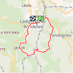
Trail Walking of 6.6 km to be discovered at New Aquitaine, Corrèze, Ladignac-sur-Rondelles. This trail is proposed by tracegps.
Description
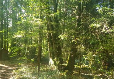
A l'est du bourg situé entre deux vallons, où sillonne ce circuit, le plateau est tranché par le ruisseau de la Rondelle qui reçoit l'Argeassou avant de rejoindre la Saint-Bonnette, (appelée aussi localement Avalouze !)... Versants boisés, fonds herbeux, les villages s'étirent sur les sommets longilignes. Un muret en pierres sèches vous conduira auprès d'une jolie église du XIIème siècle marqué d'un traditionnel clocher-mur. Face à elle, une croix calcaire du XIVème siècle présente plusieurs scènes finement ciselées. Téléchargez la fiche du circuit sur le site du Tourisme en Limousin.
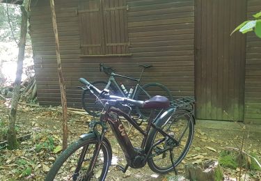
Positioning
Comments
Trails nearby
![Trail Mountain bike Espagnac - vtt Adrien Antoine et Bert - Photo](https://media.geolcdn.com/t/375/260/39d479cd-6323-4c38-843a-4a90f3864e6d.jpg&format=jpg&maxdim=2)
![Mountain bike Mountain bike](https://static1.geolcdn.com/sitytour/trail-icons/202.png)
Mountain bike
![](/images/other/stat-length.png)
![](https://static1.geolcdn.com/siteimages/upload/files/16400158638029165_repeat_loop_refresh_sync_direction_icon.png)
![Trail Walking Laguenne-sur-Avalouze - Laguenne Chemin des Puys - Photo](https://media.geolcdn.com/t/375/260/ext.jpg?maxdim=2&url=https%3A%2F%2Fstatic1.geolcdn.com%2Fsiteimages%2Fupload%2Ffiles%2F1553511878bg_sport_marche.png)
![Walking Walking](https://static1.geolcdn.com/sitytour/trail-icons/101.png)
Walking
![](/images/other/stat-length.png)
![](https://static1.geolcdn.com/siteimages/upload/files/16400158638029165_repeat_loop_refresh_sync_direction_icon.png)
![Trail Walking Laguenne-sur-Avalouze - Camping le pre du moulin - Photo](https://media.geolcdn.com/t/375/260/ext.jpg?maxdim=2&url=https%3A%2F%2Fstatic1.geolcdn.com%2Fsiteimages%2Fupload%2Ffiles%2F1553511878bg_sport_marche.png)
![Walking Walking](https://static1.geolcdn.com/sitytour/trail-icons/101.png)
Walking
![](/images/other/stat-length.png)
![](https://static1.geolcdn.com/siteimages/upload/files/16400158638029165_repeat_loop_refresh_sync_direction_icon.png)
![Trail Walking Espagnac - 20200809 balade transco - Photo](https://media.geolcdn.com/t/375/260/a0f39b60-56d3-4f69-9c8d-a3289ec20d8d.jpg&format=jpg&maxdim=2)
![Walking Walking](https://static1.geolcdn.com/sitytour/trail-icons/101.png)
Walking
![](/images/other/stat-length.png)
![](https://static1.geolcdn.com/siteimages/upload/files/16400158638029165_repeat_loop_refresh_sync_direction_icon.png)
![Trail Mountain bike Saint-Martial-de-Gimel - 20190822 GAAB 25 km - Photo](https://media.geolcdn.com/t/375/260/c67dc670-c0fd-4edb-b7f8-b99dd0b7a9d2.jpg&format=jpg&maxdim=2)
![Mountain bike Mountain bike](https://static1.geolcdn.com/sitytour/trail-icons/202.png)
Mountain bike
![](/images/other/stat-length.png)
![](https://static1.geolcdn.com/siteimages/upload/files/16400158638029165_repeat_loop_refresh_sync_direction_icon.png)
![Trail 4x4 Saint-Martial-de-Gimel - embourbé - Photo](https://media.geolcdn.com/t/375/260/a4e4dcc4-931d-4126-b2d8-16b5afdfabce.jpg&format=jpg&maxdim=2)
![4x4 4x4](https://static1.geolcdn.com/sitytour/trail-icons/403.png)
4x4
![](/images/other/stat-length.png)
![](https://static1.geolcdn.com/siteimages/upload/files/16400158638029165_repeat_loop_refresh_sync_direction_icon.png)
![Trail Road bike Espagnac - Balade du dimanche 47 km - Photo](https://media.geolcdn.com/t/375/260/bff1d879-a263-4013-a1fa-e07d7459bbcf.jpg&format=jpg&maxdim=2)
![Road bike Road bike](https://static1.geolcdn.com/sitytour/trail-icons/201.png)
Road bike
![](/images/other/stat-length.png)
![](https://static1.geolcdn.com/siteimages/upload/files/16400158638029165_repeat_loop_refresh_sync_direction_icon.png)
![Trail Walking Espagnac - Balade de reprise - Photo](https://media.geolcdn.com/t/375/260/8172a5eb-6d8b-46a6-9848-652760fe201b.jpg&format=jpg&maxdim=2)
![Walking Walking](https://static1.geolcdn.com/sitytour/trail-icons/101.png)
Walking
![](/images/other/stat-length.png)
![](https://static1.geolcdn.com/siteimages/upload/files/16400158638029165_repeat_loop_refresh_sync_direction_icon.png)
![Trail Trail Espagnac - 20200808 trail transco 17.5K 500D - Photo](https://media.geolcdn.com/t/375/260/26b3130a-62b8-420e-b7a8-2dd4594620ef.jpg&format=jpg&maxdim=2)
![Trail Trail](https://static1.geolcdn.com/sitytour/trail-icons/104.png)
Trail
![](/images/other/stat-length.png)
![](https://static1.geolcdn.com/siteimages/upload/files/16400158638029165_repeat_loop_refresh_sync_direction_icon.png)