![](/images/other/stat-length.png)
![Trail Running La Ville-aux-Clercs - Sur les Traces du Loup - La Ville aux Clercs - Photo](https://media.geolcdn.com/t/1900/400/ext.pjpeg?maxdim=2&url=https%3A%2F%2Fservices.sitytrail.com%2FGeolivesWS%2FDownloadMedia.ashx%3FTrailID%3D317966%26Media%3D17408_3.jpg)
Sur les Traces du Loup - La Ville aux Clercs
tracegps
User
![Length](/images/other/stat-length.png)
Length
31 km
![Max alt](https://static1.geolcdn.com/siteimages/upload/files/1508320355ic_sort_altitude_max_24dp.png)
Max alt
186 m
![Uphill gradient](https://static1.geolcdn.com/siteimages/upload/files/1508320355ic_sort_den_pos_24dp.png)
Uphill gradient
376 m
![Km-Effort](/images/other/stat-length.png)
Km-Effort
37 km
![Min alt](https://static1.geolcdn.com/siteimages/upload/files/1508320355ic_sort_altitude_min_24dp.png)
Min alt
110 m
![Downhill gradient](https://static1.geolcdn.com/siteimages/upload/files/1508320355ic_sort_den_neg_24dp.png)
Downhill gradient
376 m
![Boucle](https://static1.geolcdn.com/siteimages/upload/files/16400158638029165_repeat_loop_refresh_sync_direction_icon.png)
Boucle
Yes
Creation date :
2014-12-10 00:00:00.0
Updated on :
2014-12-10 00:00:00.0
![Running](https://static1.geolcdn.com/sitytour/trail-icons/103.png)
3h30
Difficulty : Difficult
![Scan this QR Code to open this trail in the SityTrail application](https://capi.geolives.com/qq0zvz2zws4bq2lad0pu/sitytour/trails/317966/qr.png?size=200)
FREE GPS app for hiking
About
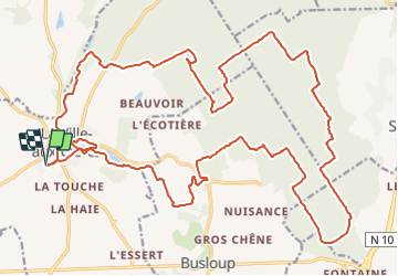
Trail Running of 31 km to be discovered at Centre-Loire Valley, Loir-et-Cher, La Ville-aux-Clercs. This trail is proposed by tracegps.
Description
Le parcours de 33km Sur les Traces du Loup. Le dénivelé avoisine les 300 m, passage de gués, lit de rivière, traces en forêts, lisières, chemins calcaires, champs, fossés… Crédit photos www.lepape-info.com
Positioning
Country:
France
Region :
Centre-Loire Valley
Department/Province :
Loir-et-Cher
Municipality :
La Ville-aux-Clercs
Location:
Unknown
Start:(Dec)
Start:(UTM)
356609 ; 5308574 (31T) N.
Comments
Trails nearby
![Trail Walking Rahart - Rahart - Photo](https://media.geolcdn.com/t/375/260/f650ba70-4d58-496b-8e3a-7549b98be635.jpg&format=jpg&maxdim=2)
![Walking Walking](https://static1.geolcdn.com/sitytour/trail-icons/101.png)
Rahart
Walking
Easy
Rahart,
Centre-Loire Valley,
Loir-et-Cher,
France
![](/images/other/stat-length.png)
8.1 km | 9.3 km-effort
2h 6min
![](https://static1.geolcdn.com/siteimages/upload/files/16400158638029165_repeat_loop_refresh_sync_direction_icon.png)
Yes
![Trail Walking Busloup - Busloup - Photo](https://media.geolcdn.com/t/375/260/ext.jpg?maxdim=2&url=https%3A%2F%2Fstatic1.geolcdn.com%2Fsiteimages%2Fupload%2Ffiles%2F1553511878bg_sport_marche.png)
![Walking Walking](https://static1.geolcdn.com/sitytour/trail-icons/101.png)
Busloup
Walking
Easy
Busloup,
Centre-Loire Valley,
Loir-et-Cher,
France
![](/images/other/stat-length.png)
21 km | 25 km-effort
3h 8min
![](https://static1.geolcdn.com/siteimages/upload/files/16400158638029165_repeat_loop_refresh_sync_direction_icon.png)
Yes
![Trail Walking La Ville-aux-Clercs - ville aux clercs - Photo](https://media.geolcdn.com/t/375/260/ext.jpg?maxdim=2&url=https%3A%2F%2Fstatic1.geolcdn.com%2Fsiteimages%2Fupload%2Ffiles%2F1553511878bg_sport_marche.png)
![Walking Walking](https://static1.geolcdn.com/sitytour/trail-icons/101.png)
ville aux clercs
Walking
Easy
La Ville-aux-Clercs,
Centre-Loire Valley,
Loir-et-Cher,
France
![](/images/other/stat-length.png)
8.3 km | 9.3 km-effort
2h 29min
![](https://static1.geolcdn.com/siteimages/upload/files/16400158638029165_repeat_loop_refresh_sync_direction_icon.png)
No
![Trail Walking Busloup - essai - Photo](https://media.geolcdn.com/t/375/260/ext.jpg?maxdim=2&url=https%3A%2F%2Fstatic1.geolcdn.com%2Fsiteimages%2Fupload%2Ffiles%2F1553511878bg_sport_marche.png)
![Walking Walking](https://static1.geolcdn.com/sitytour/trail-icons/101.png)
essai
Walking
Very easy
Busloup,
Centre-Loire Valley,
Loir-et-Cher,
France
![](/images/other/stat-length.png)
7.9 km | 9 km-effort
1h 58min
![](https://static1.geolcdn.com/siteimages/upload/files/16400158638029165_repeat_loop_refresh_sync_direction_icon.png)
Yes
![Trail Walking Busloup - essai - Photo](https://media.geolcdn.com/t/375/260/ext.jpg?maxdim=2&url=https%3A%2F%2Fstatic1.geolcdn.com%2Fsiteimages%2Fupload%2Ffiles%2F1553511878bg_sport_marche.png)
![Walking Walking](https://static1.geolcdn.com/sitytour/trail-icons/101.png)
essai
Walking
Very easy
(1)
Busloup,
Centre-Loire Valley,
Loir-et-Cher,
France
![](/images/other/stat-length.png)
7.9 km | 9 km-effort
1h 58min
![](https://static1.geolcdn.com/siteimages/upload/files/16400158638029165_repeat_loop_refresh_sync_direction_icon.png)
Yes
![Trail Walking Busloup - 29 decembre La ville aux clercs - Photo](https://media.geolcdn.com/t/375/260/ext.jpg?maxdim=2&url=https%3A%2F%2Fstatic1.geolcdn.com%2Fsiteimages%2Fupload%2Ffiles%2F1553511878bg_sport_marche.png)
![Walking Walking](https://static1.geolcdn.com/sitytour/trail-icons/101.png)
29 decembre La ville aux clercs
Walking
Very easy
Busloup,
Centre-Loire Valley,
Loir-et-Cher,
France
![](/images/other/stat-length.png)
7.9 km | 9 km-effort
1h 58min
![](https://static1.geolcdn.com/siteimages/upload/files/16400158638029165_repeat_loop_refresh_sync_direction_icon.png)
Yes
![Trail Walking Busloup - La ville aux clercs - Photo](https://media.geolcdn.com/t/375/260/ext.jpg?maxdim=2&url=https%3A%2F%2Fstatic1.geolcdn.com%2Fsiteimages%2Fupload%2Ffiles%2F1553511878bg_sport_marche.png)
![Walking Walking](https://static1.geolcdn.com/sitytour/trail-icons/101.png)
La ville aux clercs
Walking
Very easy
Busloup,
Centre-Loire Valley,
Loir-et-Cher,
France
![](/images/other/stat-length.png)
7.9 km | 9 km-effort
1h 58min
![](https://static1.geolcdn.com/siteimages/upload/files/16400158638029165_repeat_loop_refresh_sync_direction_icon.png)
Yes