![](/images/other/stat-length.png)
![Trail Walking Arvière-en-Valromey - Le Grand Colombier 1531m depuis Fivole - Photo](https://media.geolcdn.com/t/1900/400/ext.pjpeg?maxdim=2&url=https%3A%2F%2Fservices.sitytrail.com%2FGeolivesWS%2FDownloadMedia.ashx%3FTrailID%3D317813%26Media%3D17142_1.jpg)
Le Grand Colombier 1531m depuis Fivole
tracegps
User
![Length](/images/other/stat-length.png)
![Max alt](https://static1.geolcdn.com/siteimages/upload/files/1508320355ic_sort_altitude_max_24dp.png)
![Uphill gradient](https://static1.geolcdn.com/siteimages/upload/files/1508320355ic_sort_den_pos_24dp.png)
![Km-Effort](/images/other/stat-length.png)
![Min alt](https://static1.geolcdn.com/siteimages/upload/files/1508320355ic_sort_altitude_min_24dp.png)
![Downhill gradient](https://static1.geolcdn.com/siteimages/upload/files/1508320355ic_sort_den_neg_24dp.png)
![Boucle](https://static1.geolcdn.com/siteimages/upload/files/16400158638029165_repeat_loop_refresh_sync_direction_icon.png)
![Walking](https://static1.geolcdn.com/sitytour/trail-icons/101.png)
5h00
Difficulty : Medium
![Scan this QR Code to open this trail in the SityTrail application](https://capi.geolives.com/qq0zvz2zws4bq2lad0pu/sitytour/trails/317813/qr.png?size=200)
FREE GPS app for hiking
About
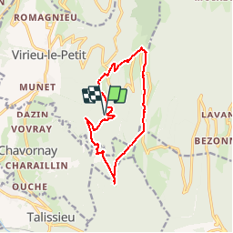
Trail Walking of 12.3 km to be discovered at Auvergne-Rhône-Alpes, Ain, Arvière-en-Valromey. This trail is proposed by tracegps.
Description
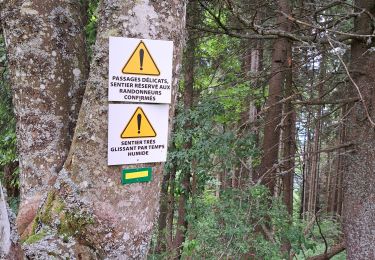
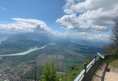
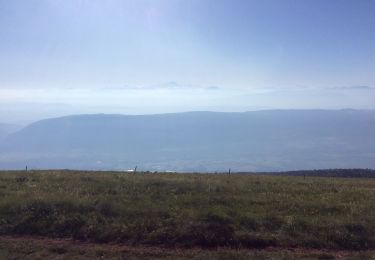
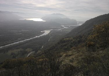
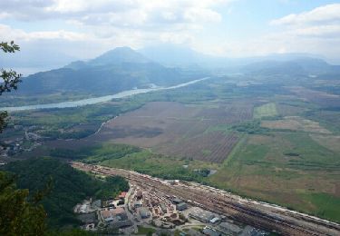
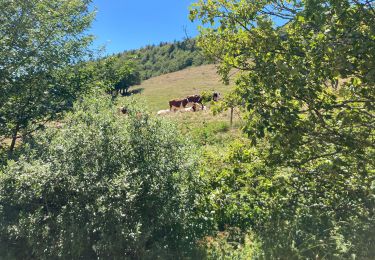
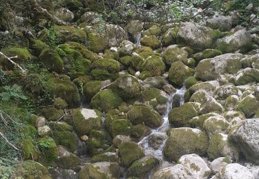
Itinéraire de montagne. En début de saison, la traversée des arêtes du Grand Colombier est une randonnée toujours agréable à parcourir. Depuis une piste forestière sous la Grange de Fivole, un chemin d'exploitation permet de rejoindre Fromentel. Pistes et sentiers montent jusqu'aux Granges du Colombier en traversant le Creux de la Roche sous le Roc Passin, pour monter à la Croix du Grand Colombier par l'alpage. C'est alors un parcours aérien des crêtes vers le Sud par la croix, le col, le sommet du Colombier, la Pierre Fillola et enfin la Pierre Amion, pour descendre vers En Pryse. Le long retour est pimenté cette fois, par la visite de Chanduraz, une surprenante arête rocheuse. De là, un réseau de pistes forestières ramène jusqu'au point de départ, en passant par les Granges d'Izéna. Description complète sur sentier-nature.com : Le Grand Colombier 1531 m, depuis Fivole Avertissement [Franchissement 1/3 ; Exposition 1/3]. Certains passages de cet itinéraire de montagne sont escarpés et/ou exposés, il est déconseillé aux enfants non accompagnés et aux personnes sujettes au vertige. Pour votre sécurité, nous vous invitons à respecter les règles suivantes : être bien chaussé, ne pas s'engager par mauvais temps, ne pas s'écarter de l'itinéraire ni des sentiers.
Positioning
Comments
Trails nearby
![Trail Walking Béon - Pierre chandruraz. - Photo](https://media.geolcdn.com/t/375/260/074e1b1a-8d87-46da-8de1-124fb8fd4758.jpg&format=jpg&maxdim=2)
![Walking Walking](https://static1.geolcdn.com/sitytour/trail-icons/101.png)
Walking
![](/images/other/stat-length.png)
![](https://static1.geolcdn.com/siteimages/upload/files/16400158638029165_repeat_loop_refresh_sync_direction_icon.png)
![Trail sport Culoz - Fenestre - Photo](https://media.geolcdn.com/t/375/260/1a8b0045-a978-442c-8ec1-037d85e229c2.jpg&format=jpg&maxdim=2)
sport
![](/images/other/stat-length.png)
![](https://static1.geolcdn.com/siteimages/upload/files/16400158638029165_repeat_loop_refresh_sync_direction_icon.png)
![Trail Walking Artemare - cascade de cerveyrieu - Photo](https://media.geolcdn.com/t/375/260/1fba5c6d-151e-4091-a127-1969b57d4eed.jpg&format=jpg&maxdim=2)
![Walking Walking](https://static1.geolcdn.com/sitytour/trail-icons/101.png)
Walking
![](/images/other/stat-length.png)
![](https://static1.geolcdn.com/siteimages/upload/files/16400158638029165_repeat_loop_refresh_sync_direction_icon.png)
![Trail Walking Arvière-en-Valromey - GR 9 - Étape 13 - Chalet d’Arvières - Chanaz - Photo](https://media.geolcdn.com/t/375/260/e124169d-20c4-4d49-b21c-03de29e41215.jpg&format=jpg&maxdim=2)
![Walking Walking](https://static1.geolcdn.com/sitytour/trail-icons/101.png)
Walking
![](/images/other/stat-length.png)
![](https://static1.geolcdn.com/siteimages/upload/files/16400158638029165_repeat_loop_refresh_sync_direction_icon.png)
![Trail Walking Anglefort - les sarrasins - Photo](https://media.geolcdn.com/t/375/260/ext.jpg?maxdim=2&url=https%3A%2F%2Fservices.sitytrail.com%2FGeolivesWS%2FDownloadMedia.ashx%3FTrailID%3D853181%26Media%3Dfix__20171025122448.jpg)
![Walking Walking](https://static1.geolcdn.com/sitytour/trail-icons/101.png)
Walking
![](/images/other/stat-length.png)
![](https://static1.geolcdn.com/siteimages/upload/files/16400158638029165_repeat_loop_refresh_sync_direction_icon.png)
![Trail Walking Béon - Roche percée - Photo](https://media.geolcdn.com/t/375/260/ext.jpg?maxdim=2&url=https%3A%2F%2Fservices.sitytrail.com%2FGeolivesWS%2FDownloadMedia.ashx%3FTrailID%3D273975%26Media%3Dfix__20140504124416.jpg)
![Walking Walking](https://static1.geolcdn.com/sitytour/trail-icons/101.png)
Walking
![](/images/other/stat-length.png)
![](https://static1.geolcdn.com/siteimages/upload/files/16400158638029165_repeat_loop_refresh_sync_direction_icon.png)
![Trail Walking Arvière-en-Valromey - GTJ 13 Chalet d'Arviere/Culoz - Photo](https://media.geolcdn.com/t/375/260/95e569a8-40e4-4cb8-99dd-166dae94e18d.jpg&format=jpg&maxdim=2)
![Walking Walking](https://static1.geolcdn.com/sitytour/trail-icons/101.png)
Walking
![](/images/other/stat-length.png)
![](https://static1.geolcdn.com/siteimages/upload/files/16400158638029165_repeat_loop_refresh_sync_direction_icon.png)
![Trail Walking Arvière-en-Valromey - Colombier - Photo](https://media.geolcdn.com/t/375/260/546e152b-a190-483a-88e2-1d49977a1ac8.jpg&format=jpg&maxdim=2)
![Walking Walking](https://static1.geolcdn.com/sitytour/trail-icons/101.png)
Walking
![](/images/other/stat-length.png)
![](https://static1.geolcdn.com/siteimages/upload/files/16400158638029165_repeat_loop_refresh_sync_direction_icon.png)
![Trail Walking Culoz - le grand colombier - Photo](https://media.geolcdn.com/t/375/260/962ad064-ea14-4f30-9afe-caca11863645.jpg&format=jpg&maxdim=2)
![Walking Walking](https://static1.geolcdn.com/sitytour/trail-icons/101.png)
Walking
![](/images/other/stat-length.png)
![](https://static1.geolcdn.com/siteimages/upload/files/16400158638029165_repeat_loop_refresh_sync_direction_icon.png)