![](/images/other/stat-length.png)
![Trail Mountain bike Lannes - La balade de Gachot - Lannes - Photo](https://media.geolcdn.com/t/1900/400/ext.pjpeg?maxdim=2&url=https%3A%2F%2Fservices.sitytrail.com%2FGeolivesWS%2FDownloadMedia.ashx%3FTrailID%3D317749%26Media%3D17062_2.jpg)
La balade de Gachot - Lannes
tracegps
User
![Length](/images/other/stat-length.png)
![Max alt](https://static1.geolcdn.com/siteimages/upload/files/1508320355ic_sort_altitude_max_24dp.png)
![Uphill gradient](https://static1.geolcdn.com/siteimages/upload/files/1508320355ic_sort_den_pos_24dp.png)
![Km-Effort](/images/other/stat-length.png)
![Min alt](https://static1.geolcdn.com/siteimages/upload/files/1508320355ic_sort_altitude_min_24dp.png)
![Downhill gradient](https://static1.geolcdn.com/siteimages/upload/files/1508320355ic_sort_den_neg_24dp.png)
![Boucle](https://static1.geolcdn.com/siteimages/upload/files/16400158638029165_repeat_loop_refresh_sync_direction_icon.png)
![Mountain bike](https://static1.geolcdn.com/sitytour/trail-icons/202.png)
49m
Difficulty : Easy
![Scan this QR Code to open this trail in the SityTrail application](https://capi.geolives.com/qq0zvz2zws4bq2lad0pu/sitytour/trails/317749/qr.png?size=200)
FREE GPS app for hiking
About
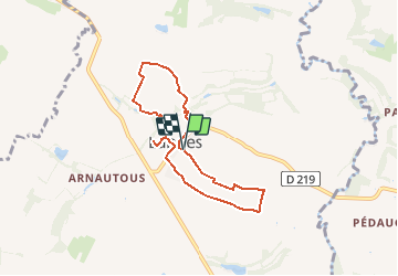
Trail Mountain bike of 6.8 km to be discovered at New Aquitaine, Lot-et-Garonne, Lannes. This trail is proposed by tracegps.
Description
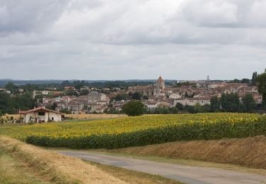
Si la première partie de ce circuit, au départ de la mairie de Lannes, est très ombragée, la seconde offre des points de vue plus lointains. Les vignes et des vergers de pruniers d’Ente sont présents au nord et au sud du circuit. Téléchargez la fiche de cette randonnée sur le site du Tourisme du Lot et Garonne.
Positioning
Comments
Trails nearby
![Trail Mountain bike Mézin - Mézin, des jardins paysagers à la table d'orientation - Pays d'Albret - Photo](https://media.geolcdn.com/t/375/260/ext.jpg?maxdim=2&url=https%3A%2F%2Fservices.sitytrail.com%2FGeolivesWS%2FDownloadMedia.ashx%3FTrailID%3D110798%26Media%3D6294_1.jpg)
![Mountain bike Mountain bike](https://static1.geolcdn.com/sitytour/trail-icons/202.png)
Mountain bike
![](/images/other/stat-length.png)
![](https://static1.geolcdn.com/siteimages/upload/files/16400158638029165_repeat_loop_refresh_sync_direction_icon.png)
![Trail Mountain bike Mézin - De Mézin, la Médiévale à Poudenas l'Italienne - Pays d'Albret - Photo](https://media.geolcdn.com/t/375/260/ext.jpg?maxdim=2&url=https%3A%2F%2Fservices.sitytrail.com%2FGeolivesWS%2FDownloadMedia.ashx%3FTrailID%3D110795%26Media%3D6293_1.jpg)
![Mountain bike Mountain bike](https://static1.geolcdn.com/sitytour/trail-icons/202.png)
Mountain bike
![](/images/other/stat-length.png)
![](https://static1.geolcdn.com/siteimages/upload/files/16400158638029165_repeat_loop_refresh_sync_direction_icon.png)
![Trail On foot Mézin - De Mézin à Villeneuve-de-Mézin, sur la route de Compostelle 16.6 km - Photo](https://media.geolcdn.com/t/375/260/ae5ee892-264d-47ca-b970-07ea0e883592.jpeg&format=jpg&maxdim=2)
![On foot On foot](https://static1.geolcdn.com/sitytour/trail-icons/100.png)
On foot
![](/images/other/stat-length.png)
![](https://static1.geolcdn.com/siteimages/upload/files/16400158638029165_repeat_loop_refresh_sync_direction_icon.png)
![Trail On foot Mézin - Mézin, des jardins paysagers à la table d'orientation 4.8 km - Photo](https://media.geolcdn.com/t/375/260/ca3ca46d-f8e9-498b-bff7-554e5a603f77.jpeg&format=jpg&maxdim=2)
![On foot On foot](https://static1.geolcdn.com/sitytour/trail-icons/100.png)
On foot
![](/images/other/stat-length.png)
![](https://static1.geolcdn.com/siteimages/upload/files/16400158638029165_repeat_loop_refresh_sync_direction_icon.png)
![Trail On foot Mézin - Mézin, des jardins paysagers à la table d'orientation variante 3.7 km km - Photo](https://media.geolcdn.com/t/375/260/ae5ee892-264d-47ca-b970-07ea0e883592.jpeg&format=jpg&maxdim=2)
![On foot On foot](https://static1.geolcdn.com/sitytour/trail-icons/100.png)
On foot
![](/images/other/stat-length.png)
![](https://static1.geolcdn.com/siteimages/upload/files/16400158638029165_repeat_loop_refresh_sync_direction_icon.png)
![Trail On foot Lannes - De Lannes à Mézin, le parfum de l'Armagnac-Ténarèze 9.6 km - Photo](https://media.geolcdn.com/t/375/260/bf01d176-dfbc-4f74-9a32-be82b3416151.jpeg&format=jpg&maxdim=2)
![On foot On foot](https://static1.geolcdn.com/sitytour/trail-icons/100.png)
On foot
![](/images/other/stat-length.png)
![](https://static1.geolcdn.com/siteimages/upload/files/16400158638029165_repeat_loop_refresh_sync_direction_icon.png)
![Trail Walking Mézin - Tustem boucle - Photo](https://media.geolcdn.com/t/375/260/00d33605-6b44-4947-b49e-1690659a9cf2.jpg&format=jpg&maxdim=2)
![Walking Walking](https://static1.geolcdn.com/sitytour/trail-icons/101.png)
Walking
![](/images/other/stat-length.png)
![](https://static1.geolcdn.com/siteimages/upload/files/16400158638029165_repeat_loop_refresh_sync_direction_icon.png)
![Trail Walking Mézin - mezin-table d'orientation-la Porte Anglaise-Mezin - Photo](https://media.geolcdn.com/t/375/260/8d0516c5-05ca-43f6-a0c6-b1f4045ada44.jpg&format=jpg&maxdim=2)
![Walking Walking](https://static1.geolcdn.com/sitytour/trail-icons/101.png)
Walking
![](/images/other/stat-length.png)
![](https://static1.geolcdn.com/siteimages/upload/files/16400158638029165_repeat_loop_refresh_sync_direction_icon.png)
![Trail On foot Lannes - Lannes, la balade de Gachot 6.9 km - Photo](https://media.geolcdn.com/t/375/260/bf01d176-dfbc-4f74-9a32-be82b3416151.jpeg&format=jpg&maxdim=2)
![On foot On foot](https://static1.geolcdn.com/sitytour/trail-icons/100.png)
On foot
![](/images/other/stat-length.png)
![](https://static1.geolcdn.com/siteimages/upload/files/16400158638029165_repeat_loop_refresh_sync_direction_icon.png)