Trail Walking Chémery-Chéhéry - De Noire Pierre au château du Rocan - Photo

De Noire Pierre au château du Rocan

 tracegps
tracegps

User

© OpenStreetMap contributors
Length
Length
11.6 km
Max alt
Max alt
320 m
Uphill gradient
Uphill gradient
267 m
Km-Effort
Km-Effort  
15.2 km
Min alt
Min alt
164 m
Downhill gradient
Downhill gradient
274 m
Boucle
Boucle
Yes
Creation date :
2014-12-10 00:00:00.0
Updated on :
2014-12-10 00:00:00.0

(0 Reviews)

Walking
Walking
2h55
Difficulty : Medium

Scan this QR Code to open this trail in the SityTrail application

FREE GPS app for hiking

Logo SityTrail SityTrail

IGN / Geographical institutes

Download SityTrail from the App Store Download SityTrail from Google Play

Logo SityTrail SityTrail World

The world is yours!

Download SityTrail from the App Store Download SityTrail from Google Play Download SityTrail on Huawei AppGallery

About

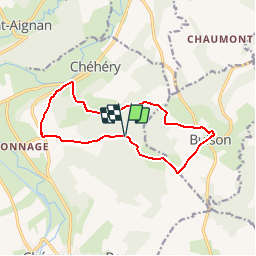
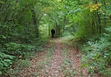
Trail Walking of 11.6 km to be discovered at Grand Est, Ardennes, Chémery-Chéhéry. This trail is proposed by tracegps.

Description

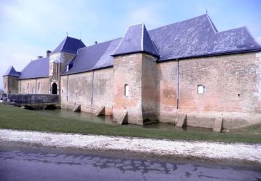
Départ du lieu dit Noire Pierre" (gîte). Monter à travers bois à la ferme d'Historia, suivre la petite route jusque Bulson et son église fortifiée. Suivre ensuite le GR14 qui vous emmène au château du Rocan. Suivre le GR14 avec une forte montée dans le bois puis suivre le chemin en face, en direction de Connage qui vous amène à Noire Pierre.

Elevation profile

Photos

Positioning

Country:
France
Region :
Grand Est
Department/Province :
Ardennes
Municipality :
Chémery-Chéhéry
Location:
Unknown
Start:(UTM)
636167 ; 5498923 (31U) N.

Trails nearby

Trail Mountain bike Omicourt - GR14 v02 - Photo
Mountain bike
ericgrunig

Mountain bike

Medium
(1)
Omicourt, Grand Est, Ardennes, France
30 km | 39 km-effort
2h 30min
Yes
Trail Walking Chémery-Chéhéry - De Chémery-sur-Bar à La Neuville via Vendresse - Photo
Walking
tracegps

Walking

Difficult
Chémery-Chéhéry, Grand Est, Ardennes, France
15.9 km | 18.2 km-effort
5h 0min
Yes
Trail Walking Raucourt-et-Flaba - de artaise à Maisoncelle 29 - Photo
Walking
veromonf

Walking

Easy
Raucourt-et-Flaba, Grand Est, Ardennes, France
14.8 km | 17.9 km-effort
3h 13min
Yes
Trail Walking Omicourt - ardennes - Photo
Walking
Bernadette Noirant

Walking

Very easy
Omicourt, Grand Est, Ardennes, France
4.8 km | 6.1 km-effort
1h 12min
No
Trail Walking Bulson - bulson - Photo
Walking
lousim22

Walking

Very easy
Bulson, Grand Est, Ardennes, France
7.8 km | 10 km-effort
2h 24min
Yes
Trail Walking Bulson - bulson - Photo
Walking
gilbertwarin08

Walking

Medium
Bulson, Grand Est, Ardennes, France
8.1 km | 10.3 km-effort
3h 10min
Yes
Trail Walking Bulson - Bulson - Photo
Walking
gilbertwarin08

Walking

Medium
Bulson, Grand Est, Ardennes, France
26 km | 33 km-effort
3h 15min
No
Trail Walking Omicourt - Omnicourt - Photo
Walking
emoreau

Walking

Very easy
Omicourt, Grand Est, Ardennes, France
5.8 km | 8.1 km-effort
1h 36min
Yes
Trail Mountain bike Omicourt - GR 14 - Photo
Mountain bike
ericgrunig

Mountain bike

Medium
Omicourt, Grand Est, Ardennes, France
26 km | 33 km-effort
1h 53min
Yes


Close
My subscriptions