![](/images/other/stat-length.png)
![Trail Walking Marseille - Le Mont Puget 563m, par le Vallon Mestrallet depuis le Col de la Gineste - Photo](https://media.geolcdn.com/t/1900/400/ext.pjpeg?maxdim=2&url=https%3A%2F%2Fservices.sitytrail.com%2FGeolivesWS%2FDownloadMedia.ashx%3FTrailID%3D317607%26Media%3D16875_1.jpg)
Le Mont Puget 563m, par le Vallon Mestrallet depuis le Col de la Gineste
tracegps
User
![Length](/images/other/stat-length.png)
![Max alt](https://static1.geolcdn.com/siteimages/upload/files/1508320355ic_sort_altitude_max_24dp.png)
![Uphill gradient](https://static1.geolcdn.com/siteimages/upload/files/1508320355ic_sort_den_pos_24dp.png)
![Km-Effort](/images/other/stat-length.png)
![Min alt](https://static1.geolcdn.com/siteimages/upload/files/1508320355ic_sort_altitude_min_24dp.png)
![Downhill gradient](https://static1.geolcdn.com/siteimages/upload/files/1508320355ic_sort_den_neg_24dp.png)
![Boucle](https://static1.geolcdn.com/siteimages/upload/files/16400158638029165_repeat_loop_refresh_sync_direction_icon.png)
![Walking](https://static1.geolcdn.com/sitytour/trail-icons/101.png)
3h00
Difficulty : Difficult
![Scan this QR Code to open this trail in the SityTrail application](https://capi.geolives.com/qq0zvz2zws4bq2lad0pu/sitytour/trails/317607/qr.png?size=200)
FREE GPS app for hiking
About
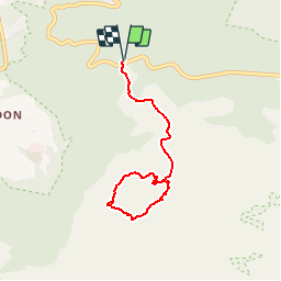
Trail Walking of 7 km to be discovered at Provence-Alpes-Côte d'Azur, Bouches-du-Rhône, Marseille. This trail is proposed by tracegps.
Description
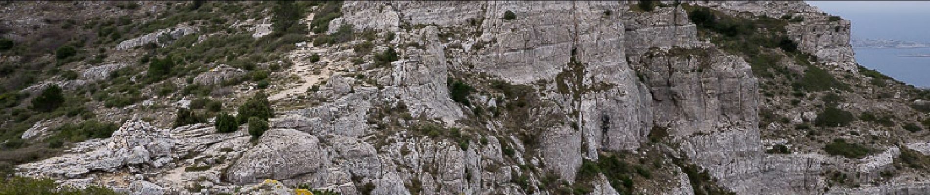
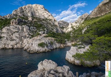
Itinéraire de montagne. Méconnu, le Vallon Mestrallet offre un parcours pittoresque pour une randonnée à travers le Mont Puget. En partant du Col de la Gineste, l'itinéraire d'approche traverse le Col Ricard pour atteindre l'aval du Vallon Mestrallet. Le cirque de falaises qui ferme le bas du vallon s'atteint par une sente. Pour en sortir, un passage étonnant permet de monter grimper l'éboulis et franchir la ceinture rocheuse de la crête des Falaises de Luminy que l'on emprunte jusqu'au point 547 du Mont Puget. La suite passe par le sommet du mont pour descendre vers le point 515 de son arête Nord Ouest et trouver une trace qui permet de dévaler l'éboulis de la rive droite du Vallon Mestrallet. Le retour vers le point de départ reprend l'itinéraire d'approche. Description complète sur sentier-nature.com : Le Mont Puget 563 m, par le Vallon Mestrallet depuis le Col de la Gineste. Avertissement [Franchissement 1/3 ; Exposition 1/3 ; Orientation 1/3]. Certains passages de cet itinéraire de montagne sont escarpés et/ou exposés, il est déconseillé aux enfants non accompagnés et aux personnes sujettes au vertige. Pour votre sécurité, nous vous invitons à respecter les règles suivantes : être bien chaussé, ne pas s'engager par mauvais temps, ne pas s'écarter de l'itinéraire ni des sentiers.
Positioning
Comments
Trails nearby
![Trail Walking Marseille - Luminy: Le chemin du Centaure - Photo](https://media.geolcdn.com/t/375/260/ext.jpg?maxdim=2&url=https%3A%2F%2Fservices.sitytrail.com%2FGeolivesWS%2FDownloadMedia.ashx%3FTrailID%3D179216%26Media%3D20130310112656.jpeg)
![Walking Walking](https://static1.geolcdn.com/sitytour/trail-icons/101.png)
Walking
![](/images/other/stat-length.png)
![](https://static1.geolcdn.com/siteimages/upload/files/16400158638029165_repeat_loop_refresh_sync_direction_icon.png)
![Trail Walking Marseille - luminy calanque sugiton calanque Morgiou - Photo](https://media.geolcdn.com/t/375/260/ext.jpg?maxdim=2&url=https%3A%2F%2Fservices.sitytrail.com%2FGeolivesWS%2FDownloadMedia.ashx%3FTrailID%3D358185%26Media%3Dfix__20141029153035.jpg)
![Walking Walking](https://static1.geolcdn.com/sitytour/trail-icons/101.png)
Walking
![](/images/other/stat-length.png)
![](https://static1.geolcdn.com/siteimages/upload/files/16400158638029165_repeat_loop_refresh_sync_direction_icon.png)
![Trail Walking Marseille - Luminy-Cassis - Photo](https://media.geolcdn.com/t/375/260/ext.jpg?maxdim=2&url=https%3A%2F%2Fservices.sitytrail.com%2FGeolivesWS%2FDownloadMedia.ashx%3FTrailID%3D230309%26Media%3Dfix__20131101131211.jpg)
![Walking Walking](https://static1.geolcdn.com/sitytour/trail-icons/101.png)
Walking
![](/images/other/stat-length.png)
![](https://static1.geolcdn.com/siteimages/upload/files/16400158638029165_repeat_loop_refresh_sync_direction_icon.png)
![Trail Walking Marseille - CE calanques morgiou et sugiton - Photo](https://media.geolcdn.com/t/375/260/f27f8a0f-14e3-4522-b1cc-023c0fb4d9dc.jpg&format=jpg&maxdim=2)
![Walking Walking](https://static1.geolcdn.com/sitytour/trail-icons/101.png)
Walking
![](/images/other/stat-length.png)
![](https://static1.geolcdn.com/siteimages/upload/files/16400158638029165_repeat_loop_refresh_sync_direction_icon.png)
![Trail Walking Marseille - Le Col de la Candelle par le couloir du Candelon, depuis le Domaine de Luminy - Photo](https://media.geolcdn.com/t/375/260/ext.jpg?maxdim=2&url=https%3A%2F%2Fservices.sitytrail.com%2FGeolivesWS%2FDownloadMedia.ashx%3FTrailID%3D317414%26Media%3D16640_1.jpg)
![Walking Walking](https://static1.geolcdn.com/sitytour/trail-icons/101.png)
Walking
![](/images/other/stat-length.png)
![](https://static1.geolcdn.com/siteimages/upload/files/16400158638029165_repeat_loop_refresh_sync_direction_icon.png)
![Trail Walking Marseille - Calanques - Aiguille Eissadon - Col Devenson - En vau - Col l'Oule - Photo](https://media.geolcdn.com/t/375/260/ext.jpg?maxdim=2&url=https%3A%2F%2Fstatic1.geolcdn.com%2Fsiteimages%2Fupload%2Ffiles%2F1553511878bg_sport_marche.png)
![Walking Walking](https://static1.geolcdn.com/sitytour/trail-icons/101.png)
Walking
![](/images/other/stat-length.png)
![](https://static1.geolcdn.com/siteimages/upload/files/16400158638029165_repeat_loop_refresh_sync_direction_icon.png)
![Trail Walking Marseille - Le Col de la Candelle par le Pas de l'OEil de Verre - Photo](https://media.geolcdn.com/t/375/260/ext.jpg?maxdim=2&url=https%3A%2F%2Fservices.sitytrail.com%2FGeolivesWS%2FDownloadMedia.ashx%3FTrailID%3D173226%26Media%3D14828_1.jpg)
![Walking Walking](https://static1.geolcdn.com/sitytour/trail-icons/101.png)
Walking
![](/images/other/stat-length.png)
![](https://static1.geolcdn.com/siteimages/upload/files/16400158638029165_repeat_loop_refresh_sync_direction_icon.png)
![Trail Walking Marseille - Traversée Morgiou - Sugiton depuis le domaine de Luminy - Photo](https://media.geolcdn.com/t/375/260/ext.jpg?maxdim=2&url=https%3A%2F%2Fservices.sitytrail.com%2FGeolivesWS%2FDownloadMedia.ashx%3FTrailID%3D172954%26Media%3D14433_1.jpg)
![Walking Walking](https://static1.geolcdn.com/sitytour/trail-icons/101.png)
Walking
![](/images/other/stat-length.png)
![](https://static1.geolcdn.com/siteimages/upload/files/16400158638029165_repeat_loop_refresh_sync_direction_icon.png)
![Trail Running Marseille - Luminy - Grand Tour - Photo](https://media.geolcdn.com/t/375/260/ext.jpg?maxdim=2&url=https%3A%2F%2Fservices.sitytrail.com%2FGeolivesWS%2FDownloadMedia.ashx%3FTrailID%3D105036%26Media%3D8596_1.jpg)
![Running Running](https://static1.geolcdn.com/sitytour/trail-icons/103.png)
Running
![](/images/other/stat-length.png)
![](https://static1.geolcdn.com/siteimages/upload/files/16400158638029165_repeat_loop_refresh_sync_direction_icon.png)