![](/images/other/stat-length.png)
![Trail Cycle Belgentier - Mont Faron - Belgentier - Photo](https://media.geolcdn.com/t/1900/400/ext.pjpeg?maxdim=2&url=https%3A%2F%2Fservices.sitytrail.com%2FGeolivesWS%2FDownloadMedia.ashx%3FTrailID%3D317555%26Media%3D16807_2.jpg)
Mont Faron - Belgentier
tracegps
User
![Length](/images/other/stat-length.png)
Length
69 km
![Max alt](https://static1.geolcdn.com/siteimages/upload/files/1508320355ic_sort_altitude_max_24dp.png)
Max alt
550 m
![Uphill gradient](https://static1.geolcdn.com/siteimages/upload/files/1508320355ic_sort_den_pos_24dp.png)
Uphill gradient
1245 m
![Km-Effort](/images/other/stat-length.png)
Km-Effort
86 km
![Min alt](https://static1.geolcdn.com/siteimages/upload/files/1508320355ic_sort_altitude_min_24dp.png)
Min alt
21 m
![Downhill gradient](https://static1.geolcdn.com/siteimages/upload/files/1508320355ic_sort_den_neg_24dp.png)
Downhill gradient
1244 m
![Boucle](https://static1.geolcdn.com/siteimages/upload/files/16400158638029165_repeat_loop_refresh_sync_direction_icon.png)
Boucle
Yes
Creation date :
2014-12-10 00:00:00.0
Updated on :
2014-12-10 00:00:00.0
![Cycle](https://static1.geolcdn.com/sitytour/trail-icons/200.png)
4h00
Difficulty : Difficult
![Scan this QR Code to open this trail in the SityTrail application](https://capi.geolives.com/qq0zvz2zws4bq2lad0pu/sitytour/trails/317555/qr.png?size=200)
FREE GPS app for hiking
About
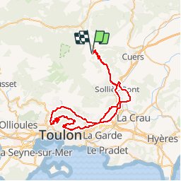
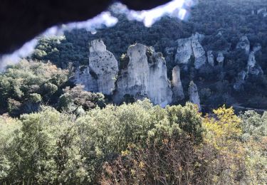
Trail Cycle of 69 km to be discovered at Provence-Alpes-Côte d'Azur, Var, Belgentier. This trail is proposed by tracegps.
Description
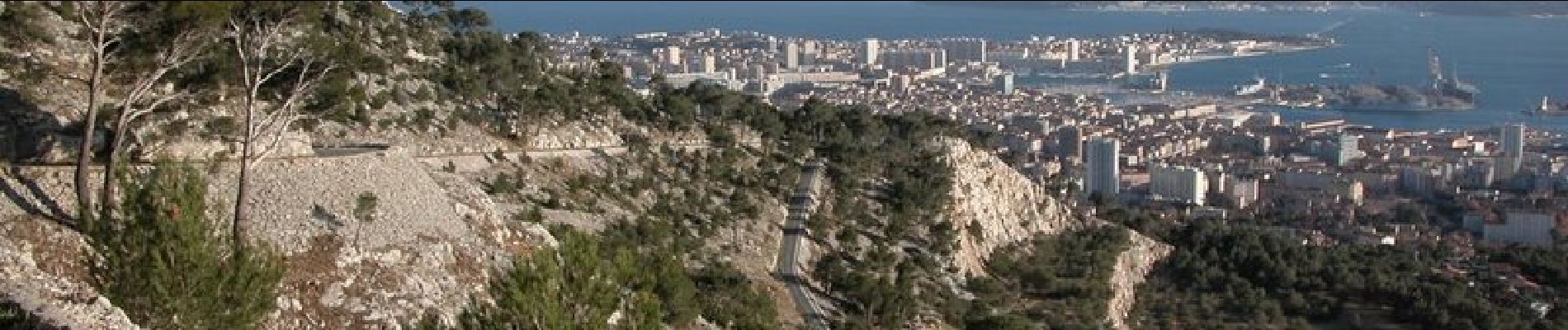
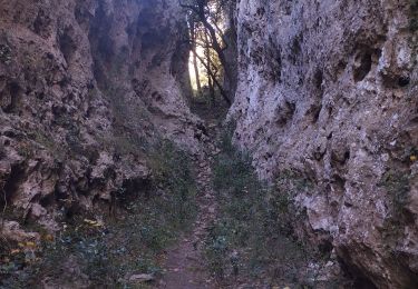
Contournez le Mont Faron par le Nord, puis faites la montée par le côté Ouest, et redescendez par le côté Est. Belle vue sur la rade de Toulon. Quelques pourcentages assez raides dans l'ascension.
Positioning
Country:
France
Region :
Provence-Alpes-Côte d'Azur
Department/Province :
Var
Municipality :
Belgentier
Location:
Unknown
Start:(Dec)
Start:(UTM)
743039 ; 4791924 (31T) N.
Comments
Trails nearby
![Trail Walking Solliès-Toucas - Morières : la Garoute et la Baume des Lumes - Photo](https://media.geolcdn.com/t/375/260/3e6ddcf9-f59d-47f4-a0ee-582c12a1d8d8.jpg&format=jpg&maxdim=2)
![Walking Walking](https://static1.geolcdn.com/sitytour/trail-icons/101.png)
Morières : la Garoute et la Baume des Lumes
Walking
Easy
(1)
Solliès-Toucas,
Provence-Alpes-Côte d'Azur,
Var,
France
![](/images/other/stat-length.png)
12.6 km | 16.7 km-effort
6h 0min
![](https://static1.geolcdn.com/siteimages/upload/files/16400158638029165_repeat_loop_refresh_sync_direction_icon.png)
Yes
![Trail Walking Belgentier - Chemin de la Foux - Pas de Belgentier - Pont de la Garoute - Photo](https://media.geolcdn.com/t/375/260/f8553ad8-25e7-40b0-a66a-b4ed67f04bdf.jpg&format=jpg&maxdim=2)
![Walking Walking](https://static1.geolcdn.com/sitytour/trail-icons/101.png)
Chemin de la Foux - Pas de Belgentier - Pont de la Garoute
Walking
Very difficult
(1)
Belgentier,
Provence-Alpes-Côte d'Azur,
Var,
France
![](/images/other/stat-length.png)
17.2 km | 26 km-effort
5h 51min
![](https://static1.geolcdn.com/siteimages/upload/files/16400158638029165_repeat_loop_refresh_sync_direction_icon.png)
Yes
![Trail Walking Solliès-Toucas - Valaury - Apier - Matheron - Photo](https://media.geolcdn.com/t/375/260/f02c0563-7d49-437f-98bb-e34f8a550dee.jpg&format=jpg&maxdim=2)
![Walking Walking](https://static1.geolcdn.com/sitytour/trail-icons/101.png)
Valaury - Apier - Matheron
Walking
Medium
(1)
Solliès-Toucas,
Provence-Alpes-Côte d'Azur,
Var,
France
![](/images/other/stat-length.png)
13.1 km | 19.5 km-effort
5h 0min
![](https://static1.geolcdn.com/siteimages/upload/files/16400158638029165_repeat_loop_refresh_sync_direction_icon.png)
Yes
![Trail Walking Solliès-Toucas - SityTrail - siou blanc - Photo](https://media.geolcdn.com/t/375/260/2137f2fb-f7c1-49df-9712-76654d4b67c0.jpg&format=jpg&maxdim=2)
![Walking Walking](https://static1.geolcdn.com/sitytour/trail-icons/101.png)
SityTrail - siou blanc
Walking
Medium
(1)
Solliès-Toucas,
Provence-Alpes-Côte d'Azur,
Var,
France
![](/images/other/stat-length.png)
12.5 km | 17.4 km-effort
6h 0min
![](https://static1.geolcdn.com/siteimages/upload/files/16400158638029165_repeat_loop_refresh_sync_direction_icon.png)
Yes
![Trail Walking Méounes-lès-Montrieux - SityTrail - montrieux gapeau - Photo](https://media.geolcdn.com/t/375/260/864c4f64-6bc1-49cf-aec6-4e1027a495ef.jpg&format=jpg&maxdim=2)
![Walking Walking](https://static1.geolcdn.com/sitytour/trail-icons/101.png)
SityTrail - montrieux gapeau
Walking
Very difficult
(2)
Méounes-lès-Montrieux,
Provence-Alpes-Côte d'Azur,
Var,
France
![](/images/other/stat-length.png)
15.9 km | 23 km-effort
5h 14min
![](https://static1.geolcdn.com/siteimages/upload/files/16400158638029165_repeat_loop_refresh_sync_direction_icon.png)
Yes
![Trail Walking Méounes-lès-Montrieux - Chartreuse de Montreuil le jeune - Photo](https://media.geolcdn.com/t/375/260/ext.jpg?maxdim=2&url=https%3A%2F%2Fservices.sitytrail.com%2FGeolivesWS%2FDownloadMedia.ashx%3FTrailID%3D627194%26Media%3Dfix__20160906115209.jpg)
![Walking Walking](https://static1.geolcdn.com/sitytour/trail-icons/101.png)
Chartreuse de Montreuil le jeune
Walking
Easy
(1)
Méounes-lès-Montrieux,
Provence-Alpes-Côte d'Azur,
Var,
France
![](/images/other/stat-length.png)
11.9 km | 17.1 km-effort
5h 10min
![](https://static1.geolcdn.com/siteimages/upload/files/16400158638029165_repeat_loop_refresh_sync_direction_icon.png)
Yes
![Trail Walking Solliès-Toucas - couvent St Hubert Valaury - Photo](https://media.geolcdn.com/t/375/260/ext.jpg?maxdim=2&url=https%3A%2F%2Fservices.sitytrail.com%2FGeolivesWS%2FDownloadMedia.ashx%3FTrailID%3D361125%26Media%3Dfix__20141108152604.jpg)
![Walking Walking](https://static1.geolcdn.com/sitytour/trail-icons/101.png)
couvent St Hubert Valaury
Walking
Very easy
(2)
Solliès-Toucas,
Provence-Alpes-Côte d'Azur,
Var,
France
![](/images/other/stat-length.png)
12.5 km | 19.2 km-effort
4h 30min
![](https://static1.geolcdn.com/siteimages/upload/files/16400158638029165_repeat_loop_refresh_sync_direction_icon.png)
Yes
![Trail Running Belgentier - les aiguilles de Valberg - Photo](https://media.geolcdn.com/t/375/260/f7c55c4c-4111-46ce-a111-35050e9f4b06.jpg&format=jpg&maxdim=2)
![Running Running](https://static1.geolcdn.com/sitytour/trail-icons/103.png)
les aiguilles de Valberg
Running
Easy
Belgentier,
Provence-Alpes-Côte d'Azur,
Var,
France
![](/images/other/stat-length.png)
12.7 km | 19.7 km-effort
1h 58min
![](https://static1.geolcdn.com/siteimages/upload/files/16400158638029165_repeat_loop_refresh_sync_direction_icon.png)
Yes
![Trail Trail Belgentier - Les aiguilles de Valberg et une arche - Photo](https://media.geolcdn.com/t/375/260/40abce3e-dd86-4ccf-960c-95975195eed4.jpg&format=jpg&maxdim=2)
![Trail Trail](https://static1.geolcdn.com/sitytour/trail-icons/104.png)
Les aiguilles de Valberg et une arche
Trail
Easy
Belgentier,
Provence-Alpes-Côte d'Azur,
Var,
France
![](/images/other/stat-length.png)
12.6 km | 19.5 km-effort
2h 17min
![](https://static1.geolcdn.com/siteimages/upload/files/16400158638029165_repeat_loop_refresh_sync_direction_icon.png)
Yes