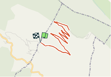
13.4 km | 25 km-effort
le mont vial
pln30
User
Length
7.7 km
Max alt
1464 m
Uphill gradient
345 m
Km-Effort
12.3 km
Min alt
1115 m
Downhill gradient
345 m
Boucle
Yes
Creation date :
2022-03-20 10:36:47.963
Updated on :
2022-03-20 14:13:06.522
3h22
Difficulty : Easy
FREE GPS app for hiking
About
Trail Walking of 7.7 km to be discovered at Provence-Alpes-Côte d'Azur, Maritime Alps, Tourette-du-Château. This trail is proposed by pln30.
Description
parcours tranquille pour monter au Mont Vial par la piste
Positioning
Country:
France
Region :
Provence-Alpes-Côte d'Azur
Department/Province :
Maritime Alps
Municipality :
Tourette-du-Château
Location:
Unknown
Start:(Dec)
Start:(UTM)
350208 ; 4861901 (32T) N.
Comments
Trails nearby
Tour du mont Lion
On foot
Medium
Gilette,
Provence-Alpes-Côte d'Azur,
Maritime Alps,
France
5h 44min
Yes
Cime des Collettes
On foot
Easy
Toudon,
Provence-Alpes-Côte d'Azur,
Maritime Alps,
France
7 km | 13.4 km-effort
3h 3min
Yes
cime des Colettes
Walking
Medium
(1)
Toudon,
Provence-Alpes-Côte d'Azur,
Maritime Alps,
France
7.7 km | 14.6 km-effort
3h 40min
No
Plan du Var-Tourrette du Château
Walking
Difficult
Bonson,
Provence-Alpes-Côte d'Azur,
Maritime Alps,
France
19.1 km | 35 km-effort
7h 50min
Yes
Balme de Vial
Walking
Medium
Revest-les-Roches,
Provence-Alpes-Côte d'Azur,
Maritime Alps,
France
7.4 km | 14.6 km-effort
5h 1min
No
Gilette - Pont de la Cerise
Walking
Medium
Gilette,
Provence-Alpes-Côte d'Azur,
Maritime Alps,
France
17.2 km | 30 km-effort
4h 29min
Yes
Bonson collet st André
Walking
Very difficult
Bonson,
Provence-Alpes-Côte d'Azur,
Maritime Alps,
France
17.1 km | 32 km-effort
5h 15min
Yes
Plan du Var : Bosson-Revest les Roches
Walking
Difficult
Bonson,
Provence-Alpes-Côte d'Azur,
Maritime Alps,
France
17.3 km | 33 km-effort
5h 14min
Yes
Gilette A/R par Tourrette du château
Walking
Very difficult
Gilette,
Provence-Alpes-Côte d'Azur,
Maritime Alps,
France
19 km | 36 km-effort
5h 54min
Yes