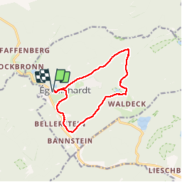
![](/images/other/stat-length.png)
![Trail Walking Éguelshardt - Autour d'Eguelshardt - Photo](https://media.geolcdn.com/t/1900/400/ext.pjpeg?maxdim=2&url=https%3A%2F%2Fservices.sitytrail.com%2FGeolivesWS%2FDownloadMedia.ashx%3FTrailID%3D317390%26Media%3D16607_5.jpg)
Autour d'Eguelshardt
tracegps
User
![Length](/images/other/stat-length.png)
![Max alt](https://static1.geolcdn.com/siteimages/upload/files/1508320355ic_sort_altitude_max_24dp.png)
![Uphill gradient](https://static1.geolcdn.com/siteimages/upload/files/1508320355ic_sort_den_pos_24dp.png)
![Km-Effort](/images/other/stat-length.png)
![Min alt](https://static1.geolcdn.com/siteimages/upload/files/1508320355ic_sort_altitude_min_24dp.png)
![Downhill gradient](https://static1.geolcdn.com/siteimages/upload/files/1508320355ic_sort_den_neg_24dp.png)
![Boucle](https://static1.geolcdn.com/siteimages/upload/files/16400158638029165_repeat_loop_refresh_sync_direction_icon.png)
![Walking](https://static1.geolcdn.com/sitytour/trail-icons/101.png)
2h40
Difficulty : Medium
![Scan this QR Code to open this trail in the SityTrail application](https://capi.geolives.com/qq0zvz2zws4bq2lad0pu/sitytour/trails/317390/qr.png?size=200)
FREE GPS app for hiking
About
Trail Walking of 10.3 km to be discovered at Grand Est, Moselle, Éguelshardt. This trail is proposed by tracegps.
Description
Se garer sur le parking de l’église d’Éguelshardt. Suivre losange jaune, rue du Waldeck, passer devant une ancienne maison à pans de bois de 1767 et le lavoir. Monter à gauche un chemin forestier vers Sandkopf. Longer les beaux rochers du Rehkoepfel. Avant d’arriver sur la route forestière, quitter le chemin balisé et tourner à droite. Arrivé au pied du château de Waldeck tourner à droite sur balisage rectangle jaune/blanc/jaune (Visite possible du château: ajouter 800 m aller-retour et le temps de visite du château). Étang de Waldeck: réserve biologique naturelle. Quitter le sentier balisé et se diriger vers la maison forestière de Waldeck. De là, suivre chemin balisé croix bleue jusqu’au stade d’Éguelshardt, le long du Falkensteinerbach rive gauche. Rejoindre l’église par rue du stade puis rue Saint-Simon.
Positioning
Comments
Trails nearby
![Trail Walking Éguelshardt - Notre Dame des Bois - Photo](https://media.geolcdn.com/t/375/260/3cf87b27-a59c-4ea6-a7bf-d652826f7266.jpg&format=jpg&maxdim=2)
![Walking Walking](https://static1.geolcdn.com/sitytour/trail-icons/101.png)
Walking
![](/images/other/stat-length.png)
![](https://static1.geolcdn.com/siteimages/upload/files/16400158638029165_repeat_loop_refresh_sync_direction_icon.png)
![Trail Walking Bitche - Etang de Hasselfurth et Hochkopf - Bitche - Photo](https://media.geolcdn.com/t/375/260/ext.jpg?maxdim=2&url=https%3A%2F%2Fservices.sitytrail.com%2FGeolivesWS%2FDownloadMedia.ashx%3FTrailID%3D317857%26Media%3D17240_6.jpg)
![Walking Walking](https://static1.geolcdn.com/sitytour/trail-icons/101.png)
Walking
![](/images/other/stat-length.png)
![](https://static1.geolcdn.com/siteimages/upload/files/16400158638029165_repeat_loop_refresh_sync_direction_icon.png)
![Trail Walking Philippsbourg - Les 3 châteaux : Falkenstein, Rothenbourg, Waldeck - Photo](https://media.geolcdn.com/t/375/260/ext.jpg?maxdim=2&url=https%3A%2F%2Fservices.sitytrail.com%2FGeolivesWS%2FDownloadMedia.ashx%3FTrailID%3D118668%26Media%3D12831_5.jpg)
![Walking Walking](https://static1.geolcdn.com/sitytour/trail-icons/101.png)
Walking
![](/images/other/stat-length.png)
![](https://static1.geolcdn.com/siteimages/upload/files/16400158638029165_repeat_loop_refresh_sync_direction_icon.png)
![Trail Walking Bitche - Étang Hasselfurth 250112 - Photo](https://media.geolcdn.com/t/375/260/3662900e-8205-4856-9f76-ac80e91a6fa5.jpg&format=jpg&maxdim=2)
![Walking Walking](https://static1.geolcdn.com/sitytour/trail-icons/101.png)
Walking
![](/images/other/stat-length.png)
![](https://static1.geolcdn.com/siteimages/upload/files/16400158638029165_repeat_loop_refresh_sync_direction_icon.png)
![Trail On foot Baerenthal - Yellow ring - Photo](https://media.geolcdn.com/t/375/260/c97fa14f-913f-4d0c-9e00-fb1aec3cafd9.jpeg&format=jpg&maxdim=2)
![On foot On foot](https://static1.geolcdn.com/sitytour/trail-icons/100.png)
On foot
![](/images/other/stat-length.png)
![](https://static1.geolcdn.com/siteimages/upload/files/16400158638029165_repeat_loop_refresh_sync_direction_icon.png)
![Trail On foot Philippsbourg - Yellow triangle - Photo](https://media.geolcdn.com/t/375/260/06ca872b-8d67-47d3-9a5d-7e9e4cc69f4c.jpeg&format=jpg&maxdim=2)
![On foot On foot](https://static1.geolcdn.com/sitytour/trail-icons/100.png)
On foot
![](/images/other/stat-length.png)
![](https://static1.geolcdn.com/siteimages/upload/files/16400158638029165_repeat_loop_refresh_sync_direction_icon.png)
![Trail On foot Philippsbourg - Blue triangle - Photo](https://media.geolcdn.com/t/375/260/7c4d1ef6-26c5-437b-8677-c479e1587290.jpeg&format=jpg&maxdim=2)
![On foot On foot](https://static1.geolcdn.com/sitytour/trail-icons/100.png)
On foot
![](/images/other/stat-length.png)
![](https://static1.geolcdn.com/siteimages/upload/files/16400158638029165_repeat_loop_refresh_sync_direction_icon.png)
![Trail On foot Baerenthal - Red ring - Photo](https://media.geolcdn.com/t/375/260/e09c10a5-8126-4ac4-b4b4-67480b4cfb80.jpeg&format=jpg&maxdim=2)
![On foot On foot](https://static1.geolcdn.com/sitytour/trail-icons/100.png)
![Trail On foot Mouterhouse - Yellow cross - Photo](https://media.geolcdn.com/t/375/260/aaa04aca-0f7b-4b8c-9cba-2f4a0cf60bff.jpeg&format=jpg&maxdim=2)
![On foot On foot](https://static1.geolcdn.com/sitytour/trail-icons/100.png)
On foot
![](/images/other/stat-length.png)
![](https://static1.geolcdn.com/siteimages/upload/files/16400158638029165_repeat_loop_refresh_sync_direction_icon.png)