Trail Mountain bike Lamoura - La Chaux Berthod et les Eterpets en VTT - Lamoura - Photo

La Chaux Berthod et les Eterpets en VTT - Lamoura

 tracegps
tracegps

User

© OpenStreetMap contributors
Length
Length
6.7 km
Max alt
Max alt
1185 m
Uphill gradient
Uphill gradient
95 m
Km-Effort
Km-Effort  
7.9 km
Min alt
Min alt
1134 m
Downhill gradient
Downhill gradient
95 m
Boucle
Boucle
Yes
Creation date :
2014-12-10 00:00:00.0
Updated on :
2014-12-10 00:00:00.0

(0 Reviews)

Mountain bike
Mountain bike
34m
Difficulty : Medium

Scan this QR Code to open this trail in the SityTrail application

FREE GPS app for hiking

Logo SityTrail SityTrail

IGN / Geographical institutes

Download SityTrail from the App Store Download SityTrail from Google Play

Logo SityTrail SityTrail World

The world is yours!

Download SityTrail from the App Store Download SityTrail from Google Play Download SityTrail on Huawei AppGallery

About

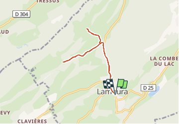
Trail Mountain bike of 6.7 km to be discovered at Bourgogne-Franche-Comté, Jura, Lamoura. This trail is proposed by tracegps.

Description

1 – Depuis l’Office de tourisme de Lamoura, suivez en direction de Saint Claude la Grande Rue (RD25) qui traverse le village. Au carrefour, devant le restaurant l’Entracte, prenez à droite la route de Longchaumois que vous suivez sur un peu plus d’1 km. 2 – Au panneau de randonnée Porte de la Chaux Berthod, prenez à gauche la route qui descend au hameau, puis suivez rapidement à droite le Chemin de la Chaux Berthod pour faire un aller-retour et découvrir l’environnement pittoresque de ce lieu. 3 - En retournant au départ du Chemin de la Chaux Berthod, prenez à droite le Chemin des Eterpets qui se transforme en chemin de terre. Prenez le temps d’observer les habitations et les paysages typiques du territoire. 4 – Le chemin s’arrête pour laisser place à un sentier, faites alors demi-tour pour rejoindre le village de Lamoura par le même itinéraire: à la sortie du hameau de la Chaux Berthod empruntez à droite la RD304 et au carrefour du village, prenez à gauche la Grande Rue pour rejoindre l’Office de tourisme. Départ : Office de tourisme de Lamoura Distance : 6,7km Dénivelés : 130m Temps : 35min Difficulté : facile en VTC, très facile en VAE Terrain : route goudronnée, chemin de terre

Elevation profile

Photos

Positioning

Country:
France
Region :
Bourgogne-Franche-Comté
Department/Province :
Jura
Municipality :
Lamoura
Location:
Unknown
Start:(Dec)
Start:(UTM)
728169 ; 5142141 (31T) N.

Trails nearby

Trail Walking Septmoncel les Molunes - circuit des chamois Septmoncel  - Photo
Walking
zoe.vienne

Walking

Difficult
(1)
Septmoncel les Molunes, Bourgogne-Franche-Comté, Jura, France
16.3 km | 31 km-effort
5h 51min
Yes
Trail Walking Lamoura - Tresberruy - Lamoura - Photo
Walking
tracegps

Walking

Difficult
(1)
Lamoura, Bourgogne-Franche-Comté, Jura, France
14.5 km | 20 km-effort
4h 0min
Yes
Trail Walking Septmoncel les Molunes - mo sentier des lapidaires - Photo
Walking
GUIDE
stef789

Walking

Medium
Septmoncel les Molunes, Bourgogne-Franche-Comté, Jura, France
10.3 km | 14.4 km-effort
3h 28min
Yes
Trail Cycle Lajoux - 2023-08-18_15h23m20_lamoura - Photo
Cycle
daniellebou

Cycle

Very easy
(1)
Lajoux, Bourgogne-Franche-Comté, Jura, France
21 km | 26 km-effort
Unknown
Yes
Trail Running Mijoux - UTTJ 2015-2 - Photo
Running
bourel.jacques

Running

Very difficult
(1)
Mijoux, Auvergne-Rhône-Alpes, Ain, France
57 km | 92 km-effort
18h 13min
No
Trail Walking Lajoux - Le crêt de la vigoureuse (le vrai) - Photo
Walking
GUIDE
stef789

Walking

Easy
Lajoux, Bourgogne-Franche-Comté, Jura, France
10.4 km | 13.4 km-effort
4h 9min
Yes
Trail Walking Lajoux - crêt vigoureuse - Photo
Walking
eltonnermou

Walking

Medium
Lajoux, Bourgogne-Franche-Comté, Jura, France
12.3 km | 16.8 km-effort
5h 0min
Yes
Trail Walking Gex - Balade à Col de la Faucille, Gex - Photo
Walking
Gaiato

Walking

Very difficult
Gex, Auvergne-Rhône-Alpes, Ain, France
86 km | 135 km-effort
9h 23min
No
Trail Bicycle tourism Mijoux - LES ROUSSES - COL DE LA FAUCILLE  - Photo
Bicycle tourism
jean-marie.parachini

Bicycle tourism

Very difficult
Mijoux, Auvergne-Rhône-Alpes, Ain, France
54 km | 68 km-effort
4h 57min
No


Close
My subscriptions