![](/images/other/stat-length.png)
![Trail Mountain bike Bois-d'Amont - Du Risoux au Lac - Bois d'Amont - Photo](https://media.geolcdn.com/t/1900/400/ext.pjpeg?maxdim=2&url=https%3A%2F%2Fservices.sitytrail.com%2FGeolivesWS%2FDownloadMedia.ashx%3FTrailID%3D317313%26Media%3D16516_1.jpg)
Du Risoux au Lac - Bois d'Amont
tracegps
User
![Length](/images/other/stat-length.png)
![Max alt](https://static1.geolcdn.com/siteimages/upload/files/1508320355ic_sort_altitude_max_24dp.png)
![Uphill gradient](https://static1.geolcdn.com/siteimages/upload/files/1508320355ic_sort_den_pos_24dp.png)
![Km-Effort](/images/other/stat-length.png)
![Min alt](https://static1.geolcdn.com/siteimages/upload/files/1508320355ic_sort_altitude_min_24dp.png)
![Downhill gradient](https://static1.geolcdn.com/siteimages/upload/files/1508320355ic_sort_den_neg_24dp.png)
![Boucle](https://static1.geolcdn.com/siteimages/upload/files/16400158638029165_repeat_loop_refresh_sync_direction_icon.png)
![Mountain bike](https://static1.geolcdn.com/sitytour/trail-icons/202.png)
2h30
Difficulty : Very difficult
![Scan this QR Code to open this trail in the SityTrail application](https://capi.geolives.com/qq0zvz2zws4bq2lad0pu/sitytour/trails/317313/qr.png?size=200)
FREE GPS app for hiking
About
Trail Mountain bike of 29 km to be discovered at Bourgogne-Franche-Comté, Jura, Bois-d'Amont. This trail is proposed by tracegps.
Description
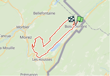
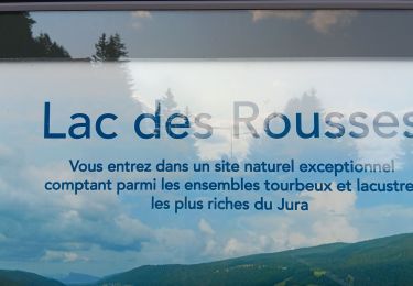
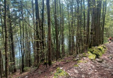
1 – Dos à l’Office de tourisme de Bois d’Amont, prenez à gauche la rue des Couenneaux. Au carrefour, tournez à droite et suivez toujours la direction de la Forêt du Risoux. 2 - La route du Risoux monte progressivement et débouche au parking des Combettes, qui est un départ de ski de fond de la Station des Rousses. Poursuivez votre parcours en suivant la route goudronnée. Au poteau directionnel de randonnée Carrefour des Coqs, suivez sur votre gauche le chemin de terre de la Combette aux Quilles. 3 - Au carrefour du Plan Pichon, continuez tout droit. Vous débouchez ensuite sur une route goudronnée, empruntez-la sur la droite. 4 – Au Chalet Rose, quittez la route pour récupérer le chemin de terre. Le chemin rattrape une route goudronnée que vous devez suivre à gauche. Rapidement, prenez à droite le chemin (route forestière du Long Chemin). 5 – Au carrefour, prenez à gauche la route goudronnée qui descend et quitte le massif forestier du Risoux. A l’intersection de la Combe de Trélarce, prenez à gauche la route qui conduit au hameau de Trélarce. Au cœur du bourg prenez la route qui part à gauche et rejoint le village des Rousses. 6 – Au carrefour des Rousses en Bas, prenez à gauche la RD29E2 et empruntez-la toujours en direction du lac des Rousses. 7 - Arrivé au lac, vous pouvez apprécier les différentes activités offertes : plages, zone de baignade, base nautique, sentier d’interprétation… Pour rejoindre votre point de départ, poursuivez votre parcours par la RD29E2 qui continue à longer la vallée de l’Orbe pour atteindre le village de Bois d’Amont. Départ : Office de tourisme de Bois d’Amont Distance : 28,5 km Dénivelés : 700m Temps : 2h30 Difficulté : très difficile en VTC et difficile en VAE Terrain : route goudronnée, chemin de terre
Positioning
Comments
Trails nearby
![Trail Walking Bois-d'Amont - Roche Bernard - Bois d'Amont - Photo](https://media.geolcdn.com/t/375/260/ext.jpg?maxdim=2&url=https%3A%2F%2Fservices.sitytrail.com%2FGeolivesWS%2FDownloadMedia.ashx%3FTrailID%3D191461%26Media%3D15055_5.jpg)
![Walking Walking](https://static1.geolcdn.com/sitytour/trail-icons/101.png)
Walking
![](/images/other/stat-length.png)
![](https://static1.geolcdn.com/siteimages/upload/files/16400158638029165_repeat_loop_refresh_sync_direction_icon.png)
![Trail Walking Bois-d'Amont - La Roche du Creux - Bois d'Amont - Photo](https://media.geolcdn.com/t/375/260/ext.jpg?maxdim=2&url=https%3A%2F%2Fservices.sitytrail.com%2FGeolivesWS%2FDownloadMedia.ashx%3FTrailID%3D191433%26Media%3D15020_5.jpg)
![Walking Walking](https://static1.geolcdn.com/sitytour/trail-icons/101.png)
Walking
![](/images/other/stat-length.png)
![](https://static1.geolcdn.com/siteimages/upload/files/16400158638029165_repeat_loop_refresh_sync_direction_icon.png)
![Trail Walking Bois-d'Amont - Le Mont Sâla - Bois d'Amont - Photo](https://media.geolcdn.com/t/375/260/ext.jpg?maxdim=2&url=https%3A%2F%2Fservices.sitytrail.com%2FGeolivesWS%2FDownloadMedia.ashx%3FTrailID%3D191430%26Media%3D15016_5.jpg)
![Walking Walking](https://static1.geolcdn.com/sitytour/trail-icons/101.png)
Walking
![](/images/other/stat-length.png)
![](https://static1.geolcdn.com/siteimages/upload/files/16400158638029165_repeat_loop_refresh_sync_direction_icon.png)
![Trail Walking Bois-d'Amont - Le Livre d'Or du Risoux - Bois d'Amont - Photo](https://media.geolcdn.com/t/375/260/ext.jpg?maxdim=2&url=https%3A%2F%2Fservices.sitytrail.com%2FGeolivesWS%2FDownloadMedia.ashx%3FTrailID%3D191405%26Media%3D14979_6.jpg)
![Walking Walking](https://static1.geolcdn.com/sitytour/trail-icons/101.png)
Walking
![](/images/other/stat-length.png)
![](https://static1.geolcdn.com/siteimages/upload/files/16400158638029165_repeat_loop_refresh_sync_direction_icon.png)
![Trail Walking Chapelle-des-Bois - ROCHE CHAMPION - Photo](https://media.geolcdn.com/t/375/260/ext.jpg?maxdim=2&url=https%3A%2F%2Fservices.sitytrail.com%2FGeolivesWS%2FDownloadMedia.ashx%3FTrailID%3D357205%26Media%3Dfix__20141026130524.jpg)
![Walking Walking](https://static1.geolcdn.com/sitytour/trail-icons/101.png)
Walking
![](/images/other/stat-length.png)
![](https://static1.geolcdn.com/siteimages/upload/files/16400158638029165_repeat_loop_refresh_sync_direction_icon.png)
![Trail On foot Bois-d'Amont - La Chaux Sèche - Photo](https://media.geolcdn.com/t/375/260/67130a55-87b2-4c49-bad2-80f6e845a64b.jpeg&format=jpg&maxdim=2)
![On foot On foot](https://static1.geolcdn.com/sitytour/trail-icons/100.png)
On foot
![](/images/other/stat-length.png)
![](https://static1.geolcdn.com/siteimages/upload/files/16400158638029165_repeat_loop_refresh_sync_direction_icon.png)
![Trail Walking Bellefontaine - Lac de Bellefontaine er lac des Mortes . - Photo](https://media.geolcdn.com/t/375/260/7671d781-54af-47e4-b735-a1a3fd8960ba.jpg&format=jpg&maxdim=2)
![Walking Walking](https://static1.geolcdn.com/sitytour/trail-icons/101.png)
Walking
![](/images/other/stat-length.png)
![](https://static1.geolcdn.com/siteimages/upload/files/16400158638029165_repeat_loop_refresh_sync_direction_icon.png)
![Trail Walking Les Rousses - lac des rousses . roche blanche . fort du risoux - Photo](https://media.geolcdn.com/t/375/260/35569d80-7092-45c8-a9d4-39991b8597b1.jpg&format=jpg&maxdim=2)
![Walking Walking](https://static1.geolcdn.com/sitytour/trail-icons/101.png)
Walking
![](/images/other/stat-length.png)
![](https://static1.geolcdn.com/siteimages/upload/files/16400158638029165_repeat_loop_refresh_sync_direction_icon.png)
![Trail Walking Les Rousses - Lac](https://media.geolcdn.com/t/375/260/9e55edf2-a12a-4787-80b5-69f110e65d81.jpg&format=jpg&maxdim=2)
![Walking Walking](https://static1.geolcdn.com/sitytour/trail-icons/101.png)
Walking
![](/images/other/stat-length.png)
![](https://static1.geolcdn.com/siteimages/upload/files/16400158638029165_repeat_loop_refresh_sync_direction_icon.png)