Trail Walking Roppeviller - Roppeviller Altschlossfelsen - Photo

Roppeviller Altschlossfelsen

 tracegps
tracegps

User

© OpenStreetMap contributors
Length
Length
6.9 km
Max alt
Max alt
408 m
Uphill gradient
Uphill gradient
191 m
Km-Effort
Km-Effort  
9.4 km
Min alt
Min alt
290 m
Downhill gradient
Downhill gradient
189 m
Boucle
Boucle
Yes
Creation date :
2014-12-10 00:00:00.0
Updated on :
2014-12-10 00:00:00.0

(1 Reviews)

Walking
Walking
2h00
Difficulty : Medium

Scan this QR Code to open this trail in the SityTrail application

FREE GPS app for hiking

Logo SityTrail SityTrail

IGN / Geographical institutes

Download SityTrail from the App Store Download SityTrail from Google Play

Logo SityTrail SityTrail World

The world is yours!

Download SityTrail from the App Store Download SityTrail from Google Play Download SityTrail on Huawei AppGallery

About

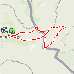
Trail Walking of 6.9 km to be discovered at Grand Est, Moselle, Roppeviller. This trail is proposed by tracegps.

Description

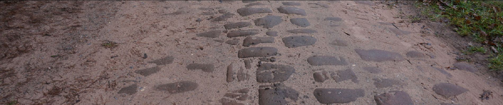
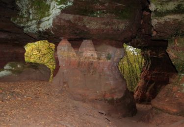
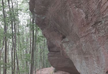
Laisser les voitures au parking près de l’église de Roppeviller. Se diriger vers la rue Principale et tourner à droite sur balisage croix jaune. Après 100m, monter à gauche sur la route puis le chemin qui vous mènera jusqu’à la frontière allemande, à 1,2km, non balisé. Tourner à droite sur balisage rectangle blanc et bleu et descendre vers les trois sculptures gallo romaines du Rocher de Diane (Diana Bild) sur le rocher de Lauerstein (voir aussi le polissoir). Continuer à longer la frontière en suivant le balisage rectangle blanc et bleu. Le camp militaire de Bitche vient jusque là, sur la droite du chemin. Longer les falaises du Altschloßfelsen, sur 1,3 km, balisage rectangle blanc et bleu. Arrivé à un carrefour, tourner à gauche sur un bon chemin, 1 km non balisé, pour revenir à la frontière que l’on franchit pour continuer vers Roppeviller, balisage croix jaune. D’abord sur un chemin avec pavés en grès (voie gallo romaine ?), puis sur la rue Principale du village et retour au parking.

Elevation profile

Photos

Positioning

Country:
France
Region :
Grand Est
Department/Province :
Moselle
Municipality :
Roppeviller
Location:
Unknown
Start:(Dec)
Start:(UTM)
391062 ; 5439785 (32U) N.

Comments

Please log in to post a review or rate the element


tout simplement magnifique !!!


Trails nearby

Trail Walking Roppeviller - Le rocher de l'Altschlossfelsen - Photo
Walking
VacheKiri67

Walking

Easy
(2)
Roppeviller, Grand Est, Moselle, France
13 km | 16.1 km-effort
3h 30min
Yes
Trail On foot Roppeviller - Circuit du rocher de l'Altschlossfelsen - Photo
On foot
GUIDE+

On foot

Easy
Roppeviller, Grand Est, Moselle, France
7.1 km | 9.7 km-effort
2h 12min
Yes
Trail On foot Schweix - Anneau rouge - Photo
On foot
GUIDE+

On foot

Easy
Schweix, Rhineland-Palatinate, Südwestpfalz, Germany
11.6 km | 14.3 km-effort
3h 15min
Yes
Trail On foot Eppenbrunn - Rundwanderweg Eppenbrunn 4 - Photo
On foot
GUIDE+

On foot

Easy
Eppenbrunn, Rhineland-Palatinate, Südwestpfalz, Germany
7 km | 9.3 km-effort
2h 7min
Yes
Trail On foot Eppenbrunn - Rundwanderweg Eppenbrunn 3 - Photo
On foot
GUIDE+

On foot

Easy
Eppenbrunn, Rhineland-Palatinate, Südwestpfalz, Germany
4.2 km | 5.8 km-effort
1h 18min
No
Trail On foot Eppenbrunn - Grenzweg - Photo
On foot
GUIDE+

On foot

Easy
Eppenbrunn, Rhineland-Palatinate, Südwestpfalz, Germany
11.3 km | 15 km-effort
3h 24min
Yes
Trail On foot Eppenbrunn - Altschloßpfad - Photo
On foot
GUIDE+

On foot

Easy
Eppenbrunn, Rhineland-Palatinate, Südwestpfalz, Germany
10 km | 13.4 km-effort
3h 3min
Yes
Trail On foot Eppenbrunn - Red dot - Photo
On foot
GUIDE+

On foot

Easy
Eppenbrunn, Rhineland-Palatinate, Südwestpfalz, Germany
9.6 km | 12.9 km-effort
2h 55min
No
Trail Walking Roppeviller - Roppeviller - Photo
Walking
GUIDE
Specialized77

Walking

Easy
Roppeviller, Grand Est, Moselle, France
6.6 km | 8.7 km-effort
2h 13min
Yes


Close
My subscriptions