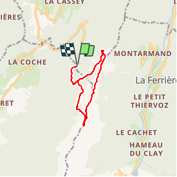
![](/images/other/stat-length.png)
![Trail Walking Crêts-en-Belledonne - Le Grand Rocher 1926m, depuis le Foyer du Barioz - Photo](https://media.geolcdn.com/t/1900/400/ext.pjpeg?maxdim=2&url=https%3A%2F%2Fservices.sitytrail.com%2FGeolivesWS%2FDownloadMedia.ashx%3FTrailID%3D317211%26Media%3D16386_1.jpg)
Le Grand Rocher 1926m, depuis le Foyer du Barioz
tracegps
User
![Length](/images/other/stat-length.png)
![Max alt](https://static1.geolcdn.com/siteimages/upload/files/1508320355ic_sort_altitude_max_24dp.png)
![Uphill gradient](https://static1.geolcdn.com/siteimages/upload/files/1508320355ic_sort_den_pos_24dp.png)
![Km-Effort](/images/other/stat-length.png)
![Min alt](https://static1.geolcdn.com/siteimages/upload/files/1508320355ic_sort_altitude_min_24dp.png)
![Downhill gradient](https://static1.geolcdn.com/siteimages/upload/files/1508320355ic_sort_den_neg_24dp.png)
![Boucle](https://static1.geolcdn.com/siteimages/upload/files/16400158638029165_repeat_loop_refresh_sync_direction_icon.png)
![Walking](https://static1.geolcdn.com/sitytour/trail-icons/101.png)
5h30
Difficulty : Medium
![Scan this QR Code to open this trail in the SityTrail application](https://capi.geolives.com/qq0zvz2zws4bq2lad0pu/sitytour/trails/317211/qr.png?size=200)
FREE GPS app for hiking
About
Trail Walking of 9.7 km to be discovered at Auvergne-Rhône-Alpes, Isère, Crêts-en-Belledonne. This trail is proposed by tracegps.
Description
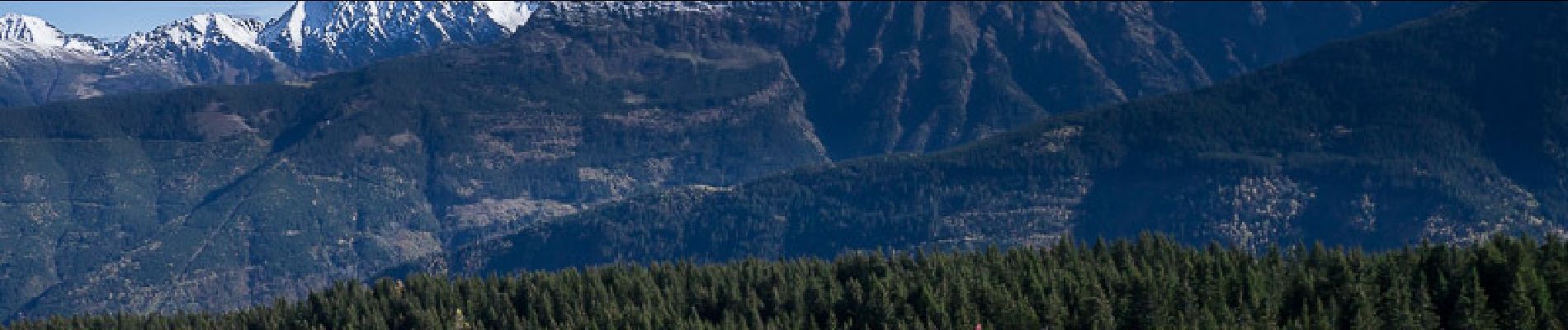
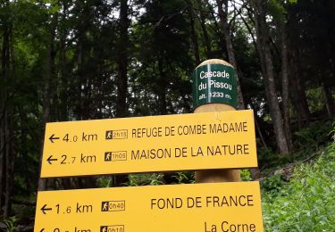
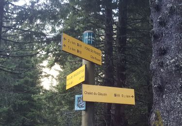
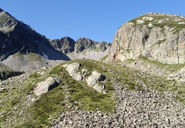
Itinéraire de montagne. Belvédère exceptionnel, le Grand Rocher, d'accès facile depuis le Foyer de Ski de Fond du Barioz, offre une vue somptueuse sur Belledonne et sur la Chartreuse orientale. L'itinéraire retenu, monte par le Chalet de Pierre Roubet, pour emprunter le vieux chemin des Ruines de la Belle Étoile qui mène à la crête, pour atteindre rapidement le sommet du Grand Rocher. Le retour suit la crête par l'antécime 1914, le Crêt Luisard et le Lac de la Belle Aiguette pour atteindre le Refuge du Crêt du Poulet. Après la visite des tables d'orientation du Crêt du Poulet, pour éviter les longs lacets de la piste pastorale, la descente idéale passe par le Chalet de Pierre Roubet pour retrouver l'itinéraire d'ascension et par là, le point de départ. Description complète sur sentier-nature.com : Le Grand Rocher 1926 m, depuis le Foyer du Barioz Avertissement [Orientation 1/3]. Pour votre sécurité, nous vous invitons à respecter les règles suivantes : être bien chaussé, ne pas s'engager par mauvais temps, ne pas s'écarter de l'itinéraire ni des sentiers.
Positioning
Comments
Trails nearby
![Trail Walking Le Haut-Bréda - Lac Blanc Lac de la Folle - Photo](https://media.geolcdn.com/t/375/260/f4e38b80-48fc-49d4-b675-d255436e858e.jpg&format=jpg&maxdim=2)
![Walking Walking](https://static1.geolcdn.com/sitytour/trail-icons/101.png)
Walking
![](/images/other/stat-length.png)
![](https://static1.geolcdn.com/siteimages/upload/files/16400158638029165_repeat_loop_refresh_sync_direction_icon.png)
![Trail Mountain bike Theys - Autour du crêt de Chazay - Photo](https://media.geolcdn.com/t/375/260/ext.jpg?maxdim=2&url=https%3A%2F%2Fstatic1.geolcdn.com%2Fsiteimages%2Fupload%2Ffiles%2F1524743154velo.jpg)
![Mountain bike Mountain bike](https://static1.geolcdn.com/sitytour/trail-icons/202.png)
Mountain bike
![](/images/other/stat-length.png)
![](https://static1.geolcdn.com/siteimages/upload/files/16400158638029165_repeat_loop_refresh_sync_direction_icon.png)
![Trail Walking Le Haut-Bréda - Les lacs sept Claux - Photo](https://media.geolcdn.com/t/375/260/ab2c771e-7afd-4d71-bf80-bad543cd1a27.jpg&format=jpg&maxdim=2)
![Walking Walking](https://static1.geolcdn.com/sitytour/trail-icons/101.png)
Walking
![](/images/other/stat-length.png)
![](https://static1.geolcdn.com/siteimages/upload/files/16400158638029165_repeat_loop_refresh_sync_direction_icon.png)
![Trail Walking Le Haut-Bréda - cascade du Pissou - Photo](https://media.geolcdn.com/t/375/260/7fdcfb11-ea55-4bb4-a796-d901baffbbd4.jpg&format=jpg&maxdim=2)
![Walking Walking](https://static1.geolcdn.com/sitytour/trail-icons/101.png)
Walking
![](/images/other/stat-length.png)
![](https://static1.geolcdn.com/siteimages/upload/files/16400158638029165_repeat_loop_refresh_sync_direction_icon.png)
![Trail Other activity Le Haut-Bréda - Rocher Blanc 7 Laux - Photo](https://media.geolcdn.com/t/375/260/ext.jpg?maxdim=2&url=https%3A%2F%2Fstatic1.geolcdn.com%2Fsiteimages%2Fupload%2Ffiles%2F1545311037marcheuse_200dpi.jpg)
![Other activity Other activity](https://static1.geolcdn.com/sitytour/trail-icons/900.png)
Other activity
![](/images/other/stat-length.png)
![](https://static1.geolcdn.com/siteimages/upload/files/16400158638029165_repeat_loop_refresh_sync_direction_icon.png)
![Trail Winter sports Crêts-en-Belledonne - Le grand Rocher - Photo](https://media.geolcdn.com/t/375/260/ext.jpg?maxdim=2&url=https%3A%2F%2Fstatic1.geolcdn.com%2Fsiteimages%2Fupload%2Ffiles%2F1524743153ski.jpg)
![Winter sports Winter sports](https://static1.geolcdn.com/sitytour/trail-icons/500.png)
Winter sports
![](/images/other/stat-length.png)
![](https://static1.geolcdn.com/siteimages/upload/files/16400158638029165_repeat_loop_refresh_sync_direction_icon.png)
![Trail Walking Crêts-en-Belledonne - le grand Rocher via le Barioz et le refuge du Cret du Poulet - Photo](https://media.geolcdn.com/t/375/260/86cc1c53-17c7-4e39-8d2c-04a896d028b8.jpg&format=jpg&maxdim=2)
![Walking Walking](https://static1.geolcdn.com/sitytour/trail-icons/101.png)
Walking
![](/images/other/stat-length.png)
![](https://static1.geolcdn.com/siteimages/upload/files/16400158638029165_repeat_loop_refresh_sync_direction_icon.png)
![Trail Walking Le Haut-Bréda - Fond de France _les 7 laux Lac Blanc - Photo](https://media.geolcdn.com/t/375/260/5bbe9704-4b9e-4378-a3de-896ab5055e35.jpg&format=jpg&maxdim=2)
![Walking Walking](https://static1.geolcdn.com/sitytour/trail-icons/101.png)
Walking
![](/images/other/stat-length.png)
![](https://static1.geolcdn.com/siteimages/upload/files/16400158638029165_repeat_loop_refresh_sync_direction_icon.png)
![Trail Walking Le Haut-Bréda - 2jours dans la vallée de la Valloire - Photo](https://media.geolcdn.com/t/375/260/9e9cf3b1-838d-469b-96fa-b30ad43a1a59.jpg&format=jpg&maxdim=2)
![Walking Walking](https://static1.geolcdn.com/sitytour/trail-icons/101.png)
Walking
![](/images/other/stat-length.png)
![](https://static1.geolcdn.com/siteimages/upload/files/16400158638029165_repeat_loop_refresh_sync_direction_icon.png)
très belle petite randonnée.