![](/images/other/stat-length.png)
![Trail Mountain bike Maurs - TransMaursoise 2008 - Maurs - Photo](https://media.geolcdn.com/t/1900/400/ext.pjpeg?maxdim=2&url=https%3A%2F%2Fservices.sitytrail.com%2FGeolivesWS%2FDownloadMedia.ashx%3FTrailID%3D317182%26Media%3D16352_4.jpg)
TransMaursoise 2008 - Maurs
tracegps
User
![Length](/images/other/stat-length.png)
Length
40 km
![Max alt](https://static1.geolcdn.com/siteimages/upload/files/1508320355ic_sort_altitude_max_24dp.png)
Max alt
634 m
![Uphill gradient](https://static1.geolcdn.com/siteimages/upload/files/1508320355ic_sort_den_pos_24dp.png)
Uphill gradient
1164 m
![Km-Effort](/images/other/stat-length.png)
Km-Effort
56 km
![Min alt](https://static1.geolcdn.com/siteimages/upload/files/1508320355ic_sort_altitude_min_24dp.png)
Min alt
251 m
![Downhill gradient](https://static1.geolcdn.com/siteimages/upload/files/1508320355ic_sort_den_neg_24dp.png)
Downhill gradient
1164 m
![Boucle](https://static1.geolcdn.com/siteimages/upload/files/16400158638029165_repeat_loop_refresh_sync_direction_icon.png)
Boucle
Yes
Creation date :
2014-12-10 00:00:00.0
Updated on :
2014-12-10 00:00:00.0
![Mountain bike](https://static1.geolcdn.com/sitytour/trail-icons/202.png)
5h00
Difficulty : Difficult
![Scan this QR Code to open this trail in the SityTrail application](https://capi.geolives.com/qq0zvz2zws4bq2lad0pu/sitytour/trails/317182/qr.png?size=200)
FREE GPS app for hiking
About
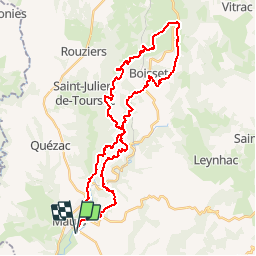
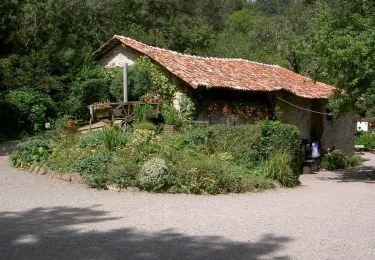
Trail Mountain bike of 40 km to be discovered at Auvergne-Rhône-Alpes, Cantal, Maurs. This trail is proposed by tracegps.
Description
Circuit VTT sympa. Dur de Leynhac à St-Antoinne. Beau retour de Calvinet à Maurs. Moins de 4Km de route. Bois et sentiers en majorité.
Positioning
Country:
France
Region :
Auvergne-Rhône-Alpes
Department/Province :
Cantal
Municipality :
Maurs
Location:
Unknown
Start:(Dec)
Start:(UTM)
436930 ; 4950425 (31T) N.
Comments
Trails nearby
![Trail Electric bike Saint-Étienne-de-Maurs - Rando maurs - Photo](https://media.geolcdn.com/t/375/260/c1400bea-82d2-440a-b6a3-74007e1e5f11.jpg&format=jpg&maxdim=2)
![Electric bike Electric bike](https://static1.geolcdn.com/sitytour/trail-icons/205.png)
Rando maurs
Electric bike
Saint-Étienne-de-Maurs,
Auvergne-Rhône-Alpes,
Cantal,
France
![](/images/other/stat-length.png)
27 km | 38 km-effort
2h 1min
![](https://static1.geolcdn.com/siteimages/upload/files/16400158638029165_repeat_loop_refresh_sync_direction_icon.png)
Yes
![Trail Walking Saint-Étienne-de-Maurs - Maurs-senerques sentier botanique - Photo](https://media.geolcdn.com/t/375/260/ext.jpg?maxdim=2&url=https%3A%2F%2Fstatic1.geolcdn.com%2Fsiteimages%2Fupload%2Ffiles%2F1553511878bg_sport_marche.png)
![Walking Walking](https://static1.geolcdn.com/sitytour/trail-icons/101.png)
Maurs-senerques sentier botanique
Walking
Very easy
(1)
Saint-Étienne-de-Maurs,
Auvergne-Rhône-Alpes,
Cantal,
France
![](/images/other/stat-length.png)
3 km | 4.1 km-effort
53min
![](https://static1.geolcdn.com/siteimages/upload/files/16400158638029165_repeat_loop_refresh_sync_direction_icon.png)
Yes
![Trail Walking Maurs - La châtaigneraie - Photo](https://media.geolcdn.com/t/375/260/c127ebf7-ae10-4bad-9a22-fca6f7551489.jpg&format=jpg&maxdim=2)
![Walking Walking](https://static1.geolcdn.com/sitytour/trail-icons/101.png)
La châtaigneraie
Walking
Very easy
Maurs,
Auvergne-Rhône-Alpes,
Cantal,
France
![](/images/other/stat-length.png)
9 km | 12.3 km-effort
2h 23min
![](https://static1.geolcdn.com/siteimages/upload/files/16400158638029165_repeat_loop_refresh_sync_direction_icon.png)
Yes
![Trail Running Saint-Constant-Fournoulès - Saint Constant Haut Célé - Photo](https://media.geolcdn.com/t/375/260/ext.jpg?maxdim=2&url=https%3A%2F%2Fservices.sitytrail.com%2FGeolivesWS%2FDownloadMedia.ashx%3FTrailID%3D317430%26Media%3D16665_1.jpg)
![Running Running](https://static1.geolcdn.com/sitytour/trail-icons/103.png)
Saint Constant Haut Célé
Running
Medium
Saint-Constant-Fournoulès,
Auvergne-Rhône-Alpes,
Cantal,
France
![](/images/other/stat-length.png)
19.3 km | 26 km-effort
2h 0min
![](https://static1.geolcdn.com/siteimages/upload/files/16400158638029165_repeat_loop_refresh_sync_direction_icon.png)
Yes
![Trail Electric bike Saint-Étienne-de-Maurs - Maurs la jolie - Photo](https://media.geolcdn.com/t/375/260/ext.jpg?maxdim=2&url=https%3A%2F%2Fstatic1.geolcdn.com%2Fsiteimages%2Fupload%2Ffiles%2F1524743154velo.jpg)
![Electric bike Electric bike](https://static1.geolcdn.com/sitytour/trail-icons/205.png)
Maurs la jolie
Electric bike
Easy
Saint-Étienne-de-Maurs,
Auvergne-Rhône-Alpes,
Cantal,
France
![](/images/other/stat-length.png)
28 km | 38 km-effort
2h 4min
![](https://static1.geolcdn.com/siteimages/upload/files/16400158638029165_repeat_loop_refresh_sync_direction_icon.png)
Yes
![Trail Walking Le Trioulou - chemin des abeilles - Photo](https://media.geolcdn.com/t/375/260/ext.jpg?maxdim=2&url=https%3A%2F%2Fstatic1.geolcdn.com%2Fsiteimages%2Fupload%2Ffiles%2F1553511878bg_sport_marche.png)
![Walking Walking](https://static1.geolcdn.com/sitytour/trail-icons/101.png)
chemin des abeilles
Walking
Very easy
Le Trioulou,
Auvergne-Rhône-Alpes,
Cantal,
France
![](/images/other/stat-length.png)
9 km | 11.8 km-effort
1h 38min
![](https://static1.geolcdn.com/siteimages/upload/files/16400158638029165_repeat_loop_refresh_sync_direction_icon.png)
Yes
![Trail Walking Maurs - Marche à St projet de cassaniouze - Photo](https://media.geolcdn.com/t/375/260/ext.jpg?maxdim=2&url=https%3A%2F%2Fstatic1.geolcdn.com%2Fsiteimages%2Fupload%2Ffiles%2F1553511878bg_sport_marche.png)
![Walking Walking](https://static1.geolcdn.com/sitytour/trail-icons/101.png)
Marche à St projet de cassaniouze
Walking
Very difficult
Maurs,
Auvergne-Rhône-Alpes,
Cantal,
France
![](/images/other/stat-length.png)
21 km | 36 km-effort
2h 12min
![](https://static1.geolcdn.com/siteimages/upload/files/16400158638029165_repeat_loop_refresh_sync_direction_icon.png)
No
![Trail Moto cross Saint-Étienne-de-Maurs - Maurs Camboulit - Photo](https://media.geolcdn.com/t/375/260/ext.jpg?maxdim=2&url=https%3A%2F%2Fstatic1.geolcdn.com%2Fsiteimages%2Fupload%2Ffiles%2F1524743155moto.jpg)
![Moto cross Moto cross](https://static1.geolcdn.com/sitytour/trail-icons/406.png)
Maurs Camboulit
Moto cross
Very easy
Saint-Étienne-de-Maurs,
Auvergne-Rhône-Alpes,
Cantal,
France
![](/images/other/stat-length.png)
55 km | 75 km-effort
Unknown
![](https://static1.geolcdn.com/siteimages/upload/files/16400158638029165_repeat_loop_refresh_sync_direction_icon.png)
No
![Trail Motorbike Maurs - Reco 1ere partie - Photo](https://media.geolcdn.com/t/375/260/ext.jpg?maxdim=2&url=https%3A%2F%2Fstatic1.geolcdn.com%2Fsiteimages%2Fupload%2Ffiles%2F1524743155moto.jpg)
![Motorbike Motorbike](https://static1.geolcdn.com/sitytour/trail-icons/402.png)
Reco 1ere partie
Motorbike
Maurs,
Auvergne-Rhône-Alpes,
Cantal,
France
![](/images/other/stat-length.png)
42 km | 59 km-effort
1h 53min
![](https://static1.geolcdn.com/siteimages/upload/files/16400158638029165_repeat_loop_refresh_sync_direction_icon.png)
No