![](/images/other/stat-length.png)
![Trail Walking Lauresses - Circuit des chemins creux et châtaigniers,- Lauresses - Photo](https://media.geolcdn.com/t/1900/400/ext.pjpeg?maxdim=2&url=https%3A%2F%2Fservices.sitytrail.com%2FGeolivesWS%2FDownloadMedia.ashx%3FTrailID%3D317117%26Media%3D16267_3.jpg)
Circuit des chemins creux et châtaigniers,- Lauresses
tracegps
User
![Length](/images/other/stat-length.png)
Length
7.8 km
![Max alt](https://static1.geolcdn.com/siteimages/upload/files/1508320355ic_sort_altitude_max_24dp.png)
Max alt
630 m
![Uphill gradient](https://static1.geolcdn.com/siteimages/upload/files/1508320355ic_sort_den_pos_24dp.png)
Uphill gradient
134 m
![Km-Effort](/images/other/stat-length.png)
Km-Effort
9.6 km
![Min alt](https://static1.geolcdn.com/siteimages/upload/files/1508320355ic_sort_altitude_min_24dp.png)
Min alt
571 m
![Downhill gradient](https://static1.geolcdn.com/siteimages/upload/files/1508320355ic_sort_den_neg_24dp.png)
Downhill gradient
134 m
![Boucle](https://static1.geolcdn.com/siteimages/upload/files/16400158638029165_repeat_loop_refresh_sync_direction_icon.png)
Boucle
Yes
Creation date :
2014-12-10 00:00:00.0
Updated on :
2014-12-10 00:00:00.0
![Walking](https://static1.geolcdn.com/sitytour/trail-icons/101.png)
2h00
Difficulty : Easy
![Scan this QR Code to open this trail in the SityTrail application](https://capi.geolives.com/qq0zvz2zws4bq2lad0pu/sitytour/trails/317117/qr.png?size=200)
FREE GPS app for hiking
About
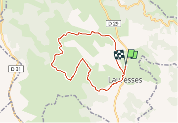
Trail Walking of 7.8 km to be discovered at Occitania, Lot, Lauresses. This trail is proposed by tracegps.
Description
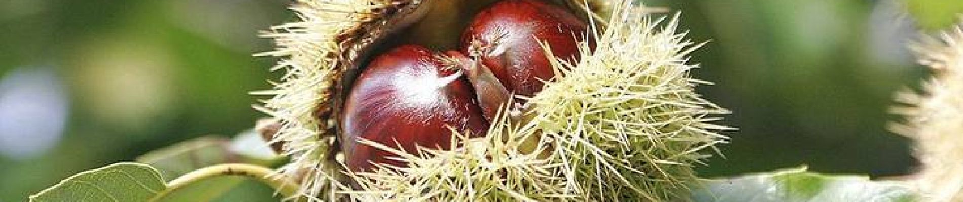
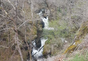
Départ de la pace de la salle des fêtes, à la sortie de Lauresses, direction Latronquière. Magnifique balade dans d'authentiques chemins creux. Le Ségala a vu ses paysages bien fournis en châtaigniers greffés jusqu'au siècle passé. Retrouvez le descriptif et le plan sur le site de l'Office de Tourisme du Haut-Ségala.
Positioning
Country:
France
Region :
Occitania
Department/Province :
Lot
Municipality :
Lauresses
Location:
Unknown
Start:(Dec)
Start:(UTM)
430654 ; 4957813 (31T) N.
Comments
Trails nearby
![Trail Equestrian Lauresses - Circuit des chemins creux et châtaigniers,- Lauresses - Photo](https://media.geolcdn.com/t/375/260/ext.jpg?maxdim=2&url=https%3A%2F%2Fservices.sitytrail.com%2FGeolivesWS%2FDownloadMedia.ashx%3FTrailID%3D317119%26Media%3D16267_3.jpg)
![Equestrian Equestrian](https://static1.geolcdn.com/sitytour/trail-icons/300.png)
Circuit des chemins creux et châtaigniers,- Lauresses
Equestrian
Easy
Lauresses,
Occitania,
Lot,
France
![](/images/other/stat-length.png)
7.8 km | 9.6 km-effort
1h 19min
![](https://static1.geolcdn.com/siteimages/upload/files/16400158638029165_repeat_loop_refresh_sync_direction_icon.png)
Yes
![Trail Mountain bike Lauresses - Circuit des chemins creux et châtaigniers,- Lauresses - Photo](https://media.geolcdn.com/t/375/260/ext.jpg?maxdim=2&url=https%3A%2F%2Fservices.sitytrail.com%2FGeolivesWS%2FDownloadMedia.ashx%3FTrailID%3D317118%26Media%3D16267_3.jpg)
![Mountain bike Mountain bike](https://static1.geolcdn.com/sitytour/trail-icons/202.png)
Circuit des chemins creux et châtaigniers,- Lauresses
Mountain bike
Easy
Lauresses,
Occitania,
Lot,
France
![](/images/other/stat-length.png)
7.8 km | 9.6 km-effort
40min
![](https://static1.geolcdn.com/siteimages/upload/files/16400158638029165_repeat_loop_refresh_sync_direction_icon.png)
Yes
![Trail Walking Sabadel-Latronquière - gouffre dès cloches - Photo](https://media.geolcdn.com/t/375/260/b58c68f6-1574-424f-9ec5-78b7509ee53a.jpg&format=jpg&maxdim=2)
![Walking Walking](https://static1.geolcdn.com/sitytour/trail-icons/101.png)
gouffre dès cloches
Walking
Difficult
Sabadel-Latronquière,
Occitania,
Lot,
France
![](/images/other/stat-length.png)
4.9 km | 7.2 km-effort
2h 35min
![](https://static1.geolcdn.com/siteimages/upload/files/16400158638029165_repeat_loop_refresh_sync_direction_icon.png)
No
![Trail Walking Lauresses - lauresses - Photo](https://media.geolcdn.com/t/375/260/ext.jpg?maxdim=2&url=https%3A%2F%2Fstatic1.geolcdn.com%2Fsiteimages%2Fupload%2Ffiles%2F1553511878bg_sport_marche.png)
![Walking Walking](https://static1.geolcdn.com/sitytour/trail-icons/101.png)
![Trail Road bike Latronquière - Saint-Céré - Photo](https://media.geolcdn.com/t/375/260/ext.jpg?maxdim=2&url=https%3A%2F%2Fstatic1.geolcdn.com%2Fsiteimages%2Fupload%2Ffiles%2F1524743154velo.jpg)
![Road bike Road bike](https://static1.geolcdn.com/sitytour/trail-icons/201.png)
![Trail Walking Lauresses - lauresses - Photo](https://media.geolcdn.com/t/375/260/ext.jpg?maxdim=2&url=https%3A%2F%2Fstatic1.geolcdn.com%2Fsiteimages%2Fupload%2Ffiles%2F1553511878bg_sport_marche.png)
![Walking Walking](https://static1.geolcdn.com/sitytour/trail-icons/101.png)
![Trail Walking Sabadel-Latronquière - sabadel - Photo](https://media.geolcdn.com/t/375/260/ext.jpg?maxdim=2&url=https%3A%2F%2Fstatic1.geolcdn.com%2Fsiteimages%2Fupload%2Ffiles%2F1553511878bg_sport_marche.png)
![Walking Walking](https://static1.geolcdn.com/sitytour/trail-icons/101.png)
sabadel
Walking
Very easy
Sabadel-Latronquière,
Occitania,
Lot,
France
![](/images/other/stat-length.png)
1.1 km | 1.8 km-effort
26min
![](https://static1.geolcdn.com/siteimages/upload/files/16400158638029165_repeat_loop_refresh_sync_direction_icon.png)
No