Trail Walking Cayenne - Circuit des Trails de Guyane -1/10 - Photo

Circuit des Trails de Guyane -1/10

 tracegps
tracegps

User

© OpenStreetMap contributors
Length
Length
15.5 km
Max alt
Max alt
114 m
Uphill gradient
Uphill gradient
432 m
Km-Effort
Km-Effort  
21 km
Min alt
Min alt
0 m
Downhill gradient
Downhill gradient
432 m
Boucle
Boucle
Yes
Creation date :
2016-03-09 00:00:00.0
Updated on :
2016-03-09 00:00:00.0

(0 Reviews)

Walking
Walking
3h00
Difficulty : Difficult

Scan this QR Code to open this trail in the SityTrail application

FREE GPS app for hiking

Logo SityTrail SityTrail

IGN / Geographical institutes

Download SityTrail from the App Store Download SityTrail from Google Play

Logo SityTrail SityTrail World

The world is yours!

Download SityTrail from the App Store Download SityTrail from Google Play Download SityTrail on Huawei AppGallery

About

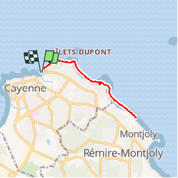
Trail Walking of 15.5 km to be discovered at French Guiana, Unknown, Cayenne. This trail is proposed by tracegps.

Description

Trail proposé par l'association Guyane Trail 2ème édition et également 2ème édition du Circuit des Trails de Guyane (circuit non officiel indépendant de la FFA ou autres organisme) comportant 10 courses, 1 course par mois à compter du mois d'octobre. Course réalisé le 05/10/2013. Première étape du Challenge des Trails de Guyane. (1/10)

Elevation profile

Photos

Positioning

Country:
France
Region :
French Guiana
Department/Province :
Unknown
Municipality :
Cayenne
Location:
Unknown
Start:(UTM)
353929 ; 546686 (22N) N.

Trails nearby

Trail Running Cayenne - Circuit des Trails de Guyane -1/10 - Photo
Running
tracegps

Running

Very difficult
Cayenne, French Guiana, Unknown, France
15.5 km | 21 km-effort
2h 0min
Yes
Trail Running Cayenne - 20190324 REMIRE MONTJOLY Les salines - Photo
Running
jknc988

Running

Medium
Cayenne, French Guiana, Unknown, France
15.4 km | 17.4 km-effort
1h 33min
Yes


Close
My subscriptions