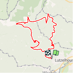
![](/images/other/stat-length.png)
![Trail Walking Lutzelhouse - Rocher de Mutzig - Lutzelhouse - Photo](https://media.geolcdn.com/t/1900/400/ext.pjpeg?maxdim=2&url=https%3A%2F%2Fservices.sitytrail.com%2FGeolivesWS%2FDownloadMedia.ashx%3FTrailID%3D317055%26Media%3D16202_6.jpg)
Rocher de Mutzig - Lutzelhouse
tracegps
User
![Length](/images/other/stat-length.png)
![Max alt](https://static1.geolcdn.com/siteimages/upload/files/1508320355ic_sort_altitude_max_24dp.png)
![Uphill gradient](https://static1.geolcdn.com/siteimages/upload/files/1508320355ic_sort_den_pos_24dp.png)
![Km-Effort](/images/other/stat-length.png)
![Min alt](https://static1.geolcdn.com/siteimages/upload/files/1508320355ic_sort_altitude_min_24dp.png)
![Downhill gradient](https://static1.geolcdn.com/siteimages/upload/files/1508320355ic_sort_den_neg_24dp.png)
![Boucle](https://static1.geolcdn.com/siteimages/upload/files/16400158638029165_repeat_loop_refresh_sync_direction_icon.png)
![Walking](https://static1.geolcdn.com/sitytour/trail-icons/101.png)
6h00
Difficulty : Difficult
![Scan this QR Code to open this trail in the SityTrail application](https://capi.geolives.com/qq0zvz2zws4bq2lad0pu/sitytour/trails/317055/qr.png?size=200)
FREE GPS app for hiking
About
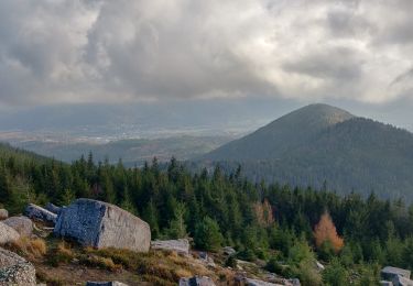
Trail Walking of 19.4 km to be discovered at Grand Est, Bas-Rhin, Lutzelhouse. This trail is proposed by tracegps.
Description
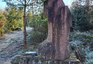
Le départ se fait du parking à proximité de la Maison Forestière du Hinberg. Emprunter le sentier en direction du Kegelplatz par la balise anneau vert. Ensuite prendre le premier chemin sur la droite en arrivant au Kegelplatz en direction de la grotte du loup. Continuer sur la route forestière qui bifurque sur la droite (triangle rouge) en direction des deux chênes puis du Waltersbach ( /! ne pas se fier à la trace allant droit au Nord pour ce passage suivre la balise indiqué /!). Arrivé au croisement du Waltersbach, emprunter le sentier qui monte sur la gauche (croix jaune) en direction de la porte de pierre. Arrivé au rocher de la porte de pierre, prendre la direction du rocher de Mutzig (rectangle rouge GR53). Au rocher de Mutzig prendre la direction du col du Narion toujours par le GR53. La trace GPS indique : Au col descendre par le rectangle rouge blanc rouge pendant environ 10 minutes pour bifurquer sur la gauche sur un sentier d'exploitation forestière pour rejoindre l'anneau jaune en direction de la grande côte. Une solution plus simple pour rejoindre la grande côte : à partir du Col du Narion, emprunter tout de suite le rond jaune au lieu de la route forestière de la Baraque aux Juifs. Arrivé au point de vue de la grande côte, rebrousser chemin sur 100m pour suivre l'anneau jaune qui descend sur la droite, jusqu’à rejoindre à la route forestière de la Baraque aux Juifs balise rouge/blanc/rouge suivre cette balise et rejoindre la maison forestière de départ.
Positioning
Comments
Trails nearby
![Trail Walking Urmatt - Cascade Soultzbach - Urmatt - Photo](https://media.geolcdn.com/t/375/260/20e7652d-0a73-4a1a-a692-b5e1164e2be3.jpg&format=jpg&maxdim=2)
![Walking Walking](https://static1.geolcdn.com/sitytour/trail-icons/101.png)
Walking
![](/images/other/stat-length.png)
![](https://static1.geolcdn.com/siteimages/upload/files/16400158638029165_repeat_loop_refresh_sync_direction_icon.png)
![Trail Mountain bike Oberhaslach - Rando des Feuilles Mortes - Photo](https://media.geolcdn.com/t/375/260/ext.jpg?maxdim=2&url=https%3A%2F%2Fservices.sitytrail.com%2FGeolivesWS%2FDownloadMedia.ashx%3FTrailID%3D101060%26Media%3D551_1.jpg)
![Mountain bike Mountain bike](https://static1.geolcdn.com/sitytour/trail-icons/202.png)
Mountain bike
![](/images/other/stat-length.png)
![](https://static1.geolcdn.com/siteimages/upload/files/16400158638029165_repeat_loop_refresh_sync_direction_icon.png)
![Trail Walking La Broque - suuntoapp-Hiking-2024-03-17T08-46-21Z - Photo](https://media.geolcdn.com/t/375/260/ff165b4c-164b-4845-8566-1950893def08.jpg&format=jpg&maxdim=2)
![Walking Walking](https://static1.geolcdn.com/sitytour/trail-icons/101.png)
Walking
![](/images/other/stat-length.png)
![](https://static1.geolcdn.com/siteimages/upload/files/16400158638029165_repeat_loop_refresh_sync_direction_icon.png)
![Trail Walking Lutzelhouse - suuntoapp-Hiking-2024-01-28T11-41-12Z - Photo](https://media.geolcdn.com/t/375/260/a449e661-4c19-4b4c-bdec-0ce5cf123351.jpg&format=jpg&maxdim=2)
![Walking Walking](https://static1.geolcdn.com/sitytour/trail-icons/101.png)
Walking
![](/images/other/stat-length.png)
![](https://static1.geolcdn.com/siteimages/upload/files/16400158638029165_repeat_loop_refresh_sync_direction_icon.png)
![Trail Walking Grendelbruch - suuntoapp-Hiking-2024-01-21T12-04-41Z - Photo](https://media.geolcdn.com/t/375/260/4df6b66c-98a9-4be9-8660-05898a66c498.jpg&format=jpg&maxdim=2)
![Walking Walking](https://static1.geolcdn.com/sitytour/trail-icons/101.png)
Walking
![](/images/other/stat-length.png)
![](https://static1.geolcdn.com/siteimages/upload/files/16400158638029165_repeat_loop_refresh_sync_direction_icon.png)
![Trail Horseback riding Lutzelhouse - 2021-07-18 Journée Le petit Wisches Le Noll - Photo](https://media.geolcdn.com/t/375/260/39fea620-a06a-4b18-bd7a-fb2bce29910c.jpg&format=jpg&maxdim=2)
![Horseback riding Horseback riding](https://static1.geolcdn.com/sitytour/trail-icons/301.png)
Horseback riding
![](/images/other/stat-length.png)
![](https://static1.geolcdn.com/siteimages/upload/files/16400158638029165_repeat_loop_refresh_sync_direction_icon.png)
![Trail Walking Lutzelhouse - 2019-11-30 Marche Rocher de Mutzig Noll - Photo](https://media.geolcdn.com/t/375/260/f1ae836b-d063-4b16-aefc-2c8e07433ca1.jpg&format=jpg&maxdim=2)
![Walking Walking](https://static1.geolcdn.com/sitytour/trail-icons/101.png)
Walking
![](/images/other/stat-length.png)
![](https://static1.geolcdn.com/siteimages/upload/files/16400158638029165_repeat_loop_refresh_sync_direction_icon.png)
![Trail Horseback riding Wisches - 2019-08-24 Picnic Russ Colbery Abri du sanglier - Photo](https://media.geolcdn.com/t/375/260/78bbc276-2b62-45fd-8eef-58ba2dce73af.jpg&format=jpg&maxdim=2)
![Horseback riding Horseback riding](https://static1.geolcdn.com/sitytour/trail-icons/301.png)
Horseback riding
![](/images/other/stat-length.png)
![](https://static1.geolcdn.com/siteimages/upload/files/16400158638029165_repeat_loop_refresh_sync_direction_icon.png)
![Trail Walking Lutzelhouse - Lutzelhouse - place des musiciens - sculptures - grotte du loup - cascade de Soulzbach - Porte de pierre - Photo](https://media.geolcdn.com/t/375/260/3c8a3f56-9ea0-46c2-a96b-81a1c8bec17b.jpg&format=jpg&maxdim=2)
![Walking Walking](https://static1.geolcdn.com/sitytour/trail-icons/101.png)
Walking
![](/images/other/stat-length.png)
![](https://static1.geolcdn.com/siteimages/upload/files/16400158638029165_repeat_loop_refresh_sync_direction_icon.png)