![](/images/other/stat-length.png)
![Trail Walking Arsac - Arsac Marais de Labarde - Photo](https://media.geolcdn.com/t/1900/400/6c5bb093-16a5-4ca2-9447-7808ee2f154a.jpg&format=pjpeg&maxdim=2)
Arsac Marais de Labarde
bedous
User
![Length](/images/other/stat-length.png)
Length
13.9 km
![Max alt](https://static1.geolcdn.com/siteimages/upload/files/1508320355ic_sort_altitude_max_24dp.png)
Max alt
27 m
![Uphill gradient](https://static1.geolcdn.com/siteimages/upload/files/1508320355ic_sort_den_pos_24dp.png)
Uphill gradient
100 m
![Km-Effort](/images/other/stat-length.png)
Km-Effort
15.2 km
![Min alt](https://static1.geolcdn.com/siteimages/upload/files/1508320355ic_sort_altitude_min_24dp.png)
Min alt
3 m
![Downhill gradient](https://static1.geolcdn.com/siteimages/upload/files/1508320355ic_sort_den_neg_24dp.png)
Downhill gradient
98 m
![Boucle](https://static1.geolcdn.com/siteimages/upload/files/16400158638029165_repeat_loop_refresh_sync_direction_icon.png)
Boucle
Yes
Creation date :
2022-03-17 08:59:56.137
Updated on :
2022-03-18 11:30:47.665
![Walking](https://static1.geolcdn.com/sitytour/trail-icons/101.png)
4h25
Difficulty : Medium
![Scan this QR Code to open this trail in the SityTrail application](https://capi.geolives.com/qq0zvz2zws4bq2lad0pu/sitytour/trails/3170260/qr.png?size=200)
FREE GPS app for hiking
About
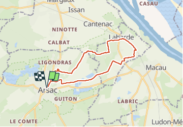
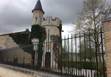
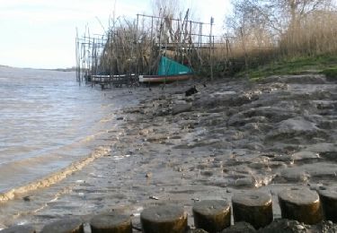
Trail Walking of 13.9 km to be discovered at New Aquitaine, Gironde, Arsac. This trail is proposed by bedous.
Description
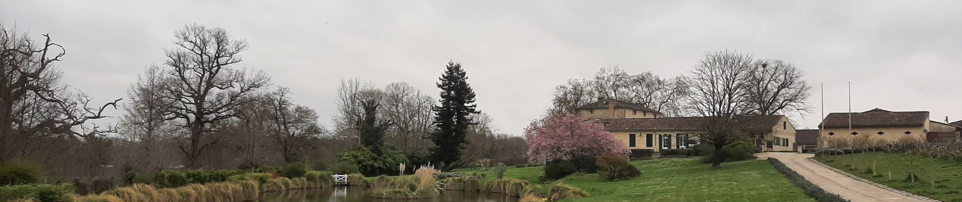
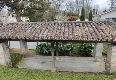
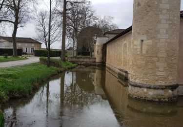
Randonnée au travers de vignes avec de magnifiques "chateaux" et la traversée en sous bois de nombreux marais bien drainés.
A faire hors temps de pluie.
Trés belle rando.
Positioning
Country:
France
Region :
New Aquitaine
Department/Province :
Gironde
Municipality :
Arsac
Location:
Unknown
Start:(Dec)
Start:(UTM)
682173 ; 4985356 (30T) N.
Comments
Trails nearby
![Trail Walking Arsac - Arsac : randonnée entre vignes et sous bois - Photo](https://media.geolcdn.com/t/375/260/0017b8f6-a385-4509-afce-f56d07fc740a.jpg&format=jpg&maxdim=2)
![Walking Walking](https://static1.geolcdn.com/sitytour/trail-icons/101.png)
Arsac : randonnée entre vignes et sous bois
Walking
Medium
Arsac,
New Aquitaine,
Gironde,
France
![](/images/other/stat-length.png)
10.6 km | 11.5 km-effort
2h 21min
![](https://static1.geolcdn.com/siteimages/upload/files/16400158638029165_repeat_loop_refresh_sync_direction_icon.png)
Yes
![Trail Walking Ludon-Médoc - Paloumey 01 - Photo](https://media.geolcdn.com/t/375/260/ext.jpg?maxdim=2&url=https%3A%2F%2Fstatic1.geolcdn.com%2Fsiteimages%2Fupload%2Ffiles%2F1553511878bg_sport_marche.png)
![Walking Walking](https://static1.geolcdn.com/sitytour/trail-icons/101.png)
Paloumey 01
Walking
Very easy
(1)
Ludon-Médoc,
New Aquitaine,
Gironde,
France
![](/images/other/stat-length.png)
4.2 km | 4.6 km-effort
1h 20min
![](https://static1.geolcdn.com/siteimages/upload/files/16400158638029165_repeat_loop_refresh_sync_direction_icon.png)
Yes
![Trail Cycle Margaux-Cantenac - Autour d'Issan - Entre vigne et Garonne - Photo](https://media.geolcdn.com/t/375/260/ext.jpg?maxdim=2&url=https%3A%2F%2Fservices.sitytrail.com%2FGeolivesWS%2FDownloadMedia.ashx%3FTrailID%3D104567%26Media%3D7949_4.jpg)
![Cycle Cycle](https://static1.geolcdn.com/sitytour/trail-icons/200.png)
Autour d'Issan - Entre vigne et Garonne
Cycle
Medium
Margaux-Cantenac,
New Aquitaine,
Gironde,
France
![](/images/other/stat-length.png)
13 km | 13.9 km-effort
1h 15min
![](https://static1.geolcdn.com/siteimages/upload/files/16400158638029165_repeat_loop_refresh_sync_direction_icon.png)
Yes
![Trail Mountain bike Margaux-Cantenac - Autour d'Issan - Entre vigne et Garonne - Photo](https://media.geolcdn.com/t/375/260/ext.jpg?maxdim=2&url=https%3A%2F%2Fservices.sitytrail.com%2FGeolivesWS%2FDownloadMedia.ashx%3FTrailID%3D104566%26Media%3D7949_4.jpg)
![Mountain bike Mountain bike](https://static1.geolcdn.com/sitytour/trail-icons/202.png)
Autour d'Issan - Entre vigne et Garonne
Mountain bike
Medium
Margaux-Cantenac,
New Aquitaine,
Gironde,
France
![](/images/other/stat-length.png)
13 km | 13.9 km-effort
1h 0min
![](https://static1.geolcdn.com/siteimages/upload/files/16400158638029165_repeat_loop_refresh_sync_direction_icon.png)
Yes
![Trail Walking Margaux-Cantenac - Autour d'Issan - Entre vigne et Garonne - Photo](https://media.geolcdn.com/t/375/260/ext.jpg?maxdim=2&url=https%3A%2F%2Fservices.sitytrail.com%2FGeolivesWS%2FDownloadMedia.ashx%3FTrailID%3D104565%26Media%3D7949_4.jpg)
![Walking Walking](https://static1.geolcdn.com/sitytour/trail-icons/101.png)
Autour d'Issan - Entre vigne et Garonne
Walking
Medium
(2)
Margaux-Cantenac,
New Aquitaine,
Gironde,
France
![](/images/other/stat-length.png)
13 km | 13.9 km-effort
2h 30min
![](https://static1.geolcdn.com/siteimages/upload/files/16400158638029165_repeat_loop_refresh_sync_direction_icon.png)
Yes
![Trail Walking Margaux-Cantenac - Margaux - Photo](https://media.geolcdn.com/t/375/260/ca4cf701-6f06-49a0-b9b1-efb58a53d587.jpg&format=jpg&maxdim=2)
![Walking Walking](https://static1.geolcdn.com/sitytour/trail-icons/101.png)
Margaux
Walking
Easy
Margaux-Cantenac,
New Aquitaine,
Gironde,
France
![](/images/other/stat-length.png)
11.4 km | 12.2 km-effort
2h 23min
![](https://static1.geolcdn.com/siteimages/upload/files/16400158638029165_repeat_loop_refresh_sync_direction_icon.png)
Yes
![Trail Walking Margaux-Cantenac - LSG Châteaux Margaux avril 2017 - Photo](https://media.geolcdn.com/t/375/260/ext.jpg?maxdim=2&url=https%3A%2F%2Fservices.sitytrail.com%2FGeolivesWS%2FDownloadMedia.ashx%3FTrailID%3D725190%26Media%3D20170402121839.jpg)
![Walking Walking](https://static1.geolcdn.com/sitytour/trail-icons/101.png)
LSG Châteaux Margaux avril 2017
Walking
Very easy
Margaux-Cantenac,
New Aquitaine,
Gironde,
France
![](/images/other/stat-length.png)
13.2 km | 14.1 km-effort
2h 23min
![](https://static1.geolcdn.com/siteimages/upload/files/16400158638029165_repeat_loop_refresh_sync_direction_icon.png)
Yes
![Trail Walking Margaux-Cantenac - vignes et jalles - Photo](https://media.geolcdn.com/t/375/260/ext.jpg?maxdim=2&url=https%3A%2F%2Fservices.sitytrail.com%2FGeolivesWS%2FDownloadMedia.ashx%3FTrailID%3D271557%26Media%3Dfix__20140223162619.jpg)
![Walking Walking](https://static1.geolcdn.com/sitytour/trail-icons/101.png)
vignes et jalles
Walking
Medium
(1)
Margaux-Cantenac,
New Aquitaine,
Gironde,
France
![](/images/other/stat-length.png)
13.4 km | 14.3 km-effort
2h 54min
![](https://static1.geolcdn.com/siteimages/upload/files/16400158638029165_repeat_loop_refresh_sync_direction_icon.png)
Yes
![Trail Walking Le Pian-Médoc - Le Pian Médoc - Photo](https://media.geolcdn.com/t/375/260/ext.jpg?maxdim=2&url=https%3A%2F%2Fstatic1.geolcdn.com%2Fsiteimages%2Fupload%2Ffiles%2F1553511878bg_sport_marche.png)
![Walking Walking](https://static1.geolcdn.com/sitytour/trail-icons/101.png)
Le Pian Médoc
Walking
Medium
Le Pian-Médoc,
New Aquitaine,
Gironde,
France
![](/images/other/stat-length.png)
11.6 km | 12.9 km-effort
3h 15min
![](https://static1.geolcdn.com/siteimages/upload/files/16400158638029165_repeat_loop_refresh_sync_direction_icon.png)
Yes