![](/images/other/stat-length.png)
![Trail Walking Perros-Guirec - Le Sentier des Douaniers à Perros-Guirec - Photo](https://media.geolcdn.com/t/1900/400/ext.pjpeg?maxdim=2&url=https%3A%2F%2Fservices.sitytrail.com%2FGeolivesWS%2FDownloadMedia.ashx%3FTrailID%3D317020%26Media%3D16162_5.jpg)
Le Sentier des Douaniers à Perros-Guirec
tracegps
User
![Length](/images/other/stat-length.png)
Length
8.1 km
![Max alt](https://static1.geolcdn.com/siteimages/upload/files/1508320355ic_sort_altitude_max_24dp.png)
Max alt
59 m
![Uphill gradient](https://static1.geolcdn.com/siteimages/upload/files/1508320355ic_sort_den_pos_24dp.png)
Uphill gradient
127 m
![Km-Effort](/images/other/stat-length.png)
Km-Effort
9.9 km
![Min alt](https://static1.geolcdn.com/siteimages/upload/files/1508320355ic_sort_altitude_min_24dp.png)
Min alt
-1 m
![Downhill gradient](https://static1.geolcdn.com/siteimages/upload/files/1508320355ic_sort_den_neg_24dp.png)
Downhill gradient
146 m
![Boucle](https://static1.geolcdn.com/siteimages/upload/files/16400158638029165_repeat_loop_refresh_sync_direction_icon.png)
Boucle
No
Creation date :
2014-12-10 00:00:00.0
Updated on :
2014-12-10 00:00:00.0
![Walking](https://static1.geolcdn.com/sitytour/trail-icons/101.png)
2h30
Difficulty : Medium
![Scan this QR Code to open this trail in the SityTrail application](https://capi.geolives.com/qq0zvz2zws4bq2lad0pu/sitytour/trails/317020/qr.png?size=200)
FREE GPS app for hiking
About
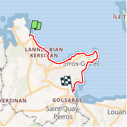
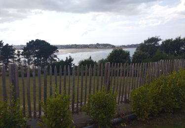
Trail Walking of 8.1 km to be discovered at Brittany, Côtes-d'Armor, Perros-Guirec. This trail is proposed by tracegps.
Description
Très jolie promenade sur le Sentier des Douaniers. Vue sur la mer et découverte sur le chemin d'une superbe plage avec ses commerces (Trestaou).
Positioning
Country:
France
Region :
Brittany
Department/Province :
Côtes-d'Armor
Municipality :
Perros-Guirec
Location:
Unknown
Start:(Dec)
Start:(UTM)
465199 ; 5408376 (30U) N.
Comments
Trails nearby
![Trail Walking Perros-Guirec - Perros-Guirec - GR34 - 11.1km 185m 2h50 - 2023 09 08 - Photo](https://media.geolcdn.com/t/375/260/d1728063-b6c3-4241-bba7-0eab61cebb20.jpg&format=jpg&maxdim=2)
![Walking Walking](https://static1.geolcdn.com/sitytour/trail-icons/101.png)
Perros-Guirec - GR34 - 11.1km 185m 2h50 - 2023 09 08
Walking
Medium
(1)
Perros-Guirec,
Brittany,
Côtes-d'Armor,
France
![](/images/other/stat-length.png)
11.1 km | 13.6 km-effort
2h 50min
![](https://static1.geolcdn.com/siteimages/upload/files/16400158638029165_repeat_loop_refresh_sync_direction_icon.png)
Yes
![Trail Walking Trégastel - Trégastel - GR34 Île Renote Moulin à marée Chapelle de Gorgon - 13.8km 100m 3h35 - 2023 09 07 - Photo](https://media.geolcdn.com/t/375/260/f7b585bc-cd92-4f03-b6f8-635e10f5e6be.jpg&format=jpg&maxdim=2)
![Walking Walking](https://static1.geolcdn.com/sitytour/trail-icons/101.png)
Trégastel - GR34 Île Renote Moulin à marée Chapelle de Gorgon - 13.8km 100m 3...
Walking
Difficult
(2)
Trégastel,
Brittany,
Côtes-d'Armor,
France
![](/images/other/stat-length.png)
13.8 km | 15.1 km-effort
3h 35min
![](https://static1.geolcdn.com/siteimages/upload/files/16400158638029165_repeat_loop_refresh_sync_direction_icon.png)
Yes
![Trail Walking Perros-Guirec - la côte de granit rose à Ploumanach - Photo](https://media.geolcdn.com/t/375/260/64deb34e-d59c-4f9a-95ec-bcb98ff541ad.jpg&format=jpg&maxdim=2)
![Walking Walking](https://static1.geolcdn.com/sitytour/trail-icons/101.png)
la côte de granit rose à Ploumanach
Walking
Very easy
(2)
Perros-Guirec,
Brittany,
Côtes-d'Armor,
France
![](/images/other/stat-length.png)
6 km | 6.9 km-effort
2h 38min
![](https://static1.geolcdn.com/siteimages/upload/files/16400158638029165_repeat_loop_refresh_sync_direction_icon.png)
Yes
![Trail Walking Perros-Guirec - Les sentiers de Ploumanac'h - Photo](https://media.geolcdn.com/t/375/260/ext.jpg?maxdim=2&url=https%3A%2F%2Fservices.sitytrail.com%2FGeolivesWS%2FDownloadMedia.ashx%3FTrailID%3D317019%26Media%3D16161_1.jpg)
![Walking Walking](https://static1.geolcdn.com/sitytour/trail-icons/101.png)
Les sentiers de Ploumanac'h
Walking
Medium
(2)
Perros-Guirec,
Brittany,
Côtes-d'Armor,
France
![](/images/other/stat-length.png)
10.3 km | 12 km-effort
3h 0min
![](https://static1.geolcdn.com/siteimages/upload/files/16400158638029165_repeat_loop_refresh_sync_direction_icon.png)
Yes
![Trail Walking Louannec - Louannec - GR34 PR - 11.5km 185m 3h00 (40mn) - 2023 09 14 - Photo](https://media.geolcdn.com/t/375/260/e980ede6-67ca-4aa3-94c9-619423761500.jpg&format=jpg&maxdim=2)
![Walking Walking](https://static1.geolcdn.com/sitytour/trail-icons/101.png)
Louannec - GR34 PR - 11.5km 185m 3h00 (40mn) - 2023 09 14
Walking
Difficult
Louannec,
Brittany,
Côtes-d'Armor,
France
![](/images/other/stat-length.png)
11.5 km | 13.9 km-effort
3h 0min
![](https://static1.geolcdn.com/siteimages/upload/files/16400158638029165_repeat_loop_refresh_sync_direction_icon.png)
Yes
![Trail Walking Trégastel - Trégastel - GR34 Ploumanac'h Kasino de Perros-Guirec - 11.7km 200m 2h55 (50mn) - 2023 09 08 - Photo](https://media.geolcdn.com/t/375/260/3132b43e-4920-4682-bf35-15b1d429cbae.jpg&format=jpg&maxdim=2)
![Walking Walking](https://static1.geolcdn.com/sitytour/trail-icons/101.png)
Trégastel - GR34 Ploumanac'h Kasino de Perros-Guirec - 11.7km 200m 2h55 (50mn...
Walking
Medium
Trégastel,
Brittany,
Côtes-d'Armor,
France
![](/images/other/stat-length.png)
11.7 km | 14.4 km-effort
2h 55min
![](https://static1.geolcdn.com/siteimages/upload/files/16400158638029165_repeat_loop_refresh_sync_direction_icon.png)
Yes
![Trail Walking Pleumeur-Bodou - Pleumeur-Bodou - GR34 Chapelle Saint-Samson - 7.7km 60m 1h55 - 2023 09 06 - Photo](https://media.geolcdn.com/t/375/260/5d74374c-67e8-400e-845c-98d92708147a.jpg&format=jpg&maxdim=2)
![Walking Walking](https://static1.geolcdn.com/sitytour/trail-icons/101.png)
Pleumeur-Bodou - GR34 Chapelle Saint-Samson - 7.7km 60m 1h55 - 2023 09 06
Walking
Medium
Pleumeur-Bodou,
Brittany,
Côtes-d'Armor,
France
![](/images/other/stat-length.png)
7.7 km | 8.5 km-effort
1h 55min
![](https://static1.geolcdn.com/siteimages/upload/files/16400158638029165_repeat_loop_refresh_sync_direction_icon.png)
Yes
![Trail Bicycle tourism Pleumeur-Bodou - Landrellec à kercoz - Photo](https://media.geolcdn.com/t/375/260/9edc18fe-d348-4dcd-a457-97cbb66b8768.jpg&format=jpg&maxdim=2)
![Bicycle tourism Bicycle tourism](https://static1.geolcdn.com/sitytour/trail-icons/204.png)
Landrellec à kercoz
Bicycle tourism
Easy
Pleumeur-Bodou,
Brittany,
Côtes-d'Armor,
France
![](/images/other/stat-length.png)
52 km | 61 km-effort
4h 19min
![](https://static1.geolcdn.com/siteimages/upload/files/16400158638029165_repeat_loop_refresh_sync_direction_icon.png)
No
![Trail Walking Trégastel - GR34-EtapeIII-J05 - Photo](https://media.geolcdn.com/t/375/260/ext.jpg?maxdim=2&url=https%3A%2F%2Fstatic1.geolcdn.com%2Fsiteimages%2Fupload%2Ffiles%2F1553511878bg_sport_marche.png)
![Walking Walking](https://static1.geolcdn.com/sitytour/trail-icons/101.png)
GR34-EtapeIII-J05
Walking
Easy
(1)
Trégastel,
Brittany,
Côtes-d'Armor,
France
![](/images/other/stat-length.png)
19.2 km | 21 km-effort
6h 30min
![](https://static1.geolcdn.com/siteimages/upload/files/16400158638029165_repeat_loop_refresh_sync_direction_icon.png)
No