![](/images/other/stat-length.png)
![Trail Walking Valvignères - Les Crêtes de Berg - Valvignières - Photo](https://media.geolcdn.com/t/1900/400/ext.pjpeg?maxdim=2&url=https%3A%2F%2Fservices.sitytrail.com%2FGeolivesWS%2FDownloadMedia.ashx%3FTrailID%3D317002%26Media%3D16135_2.jpg)
Les Crêtes de Berg - Valvignières
tracegps
User
![Length](/images/other/stat-length.png)
![Max alt](https://static1.geolcdn.com/siteimages/upload/files/1508320355ic_sort_altitude_max_24dp.png)
![Uphill gradient](https://static1.geolcdn.com/siteimages/upload/files/1508320355ic_sort_den_pos_24dp.png)
![Km-Effort](/images/other/stat-length.png)
![Min alt](https://static1.geolcdn.com/siteimages/upload/files/1508320355ic_sort_altitude_min_24dp.png)
![Downhill gradient](https://static1.geolcdn.com/siteimages/upload/files/1508320355ic_sort_den_neg_24dp.png)
![Boucle](https://static1.geolcdn.com/siteimages/upload/files/16400158638029165_repeat_loop_refresh_sync_direction_icon.png)
![Walking](https://static1.geolcdn.com/sitytour/trail-icons/101.png)
5h00
Difficulty : Difficult
![Scan this QR Code to open this trail in the SityTrail application](https://capi.geolives.com/qq0zvz2zws4bq2lad0pu/sitytour/trails/317002/qr.png?size=200)
FREE GPS app for hiking
About
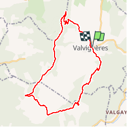
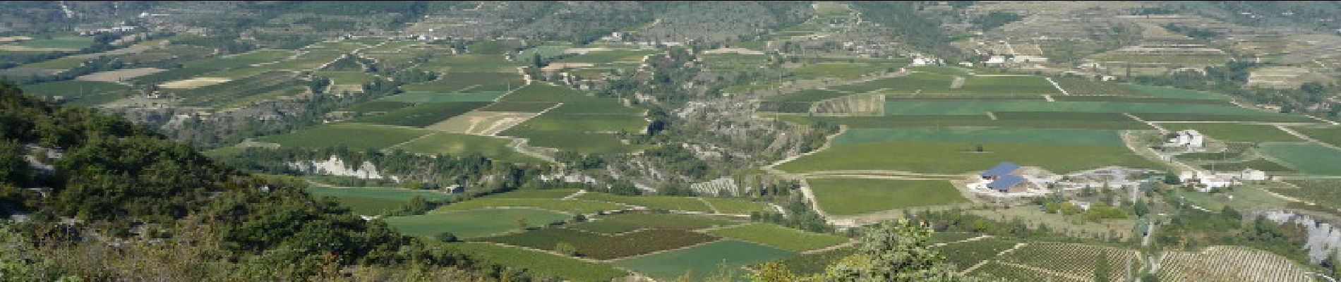
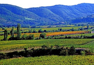
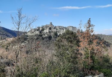
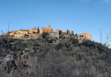
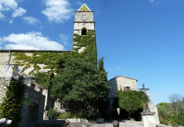
Trail Walking of 17.9 km to be discovered at Auvergne-Rhône-Alpes, Ardèche, Valvignères. This trail is proposed by tracegps.
Description
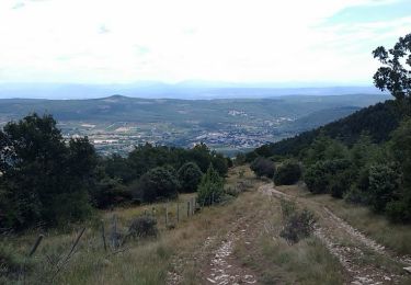
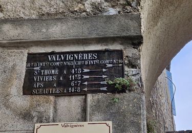
Du panneau "Inforando" partir vers le camping et monter vers la crête du Serre de Levrou pour trouver le Col de la Fare et remonter au Coignas. Suivre vers le sud la crête de la Montagne de Berg. Quitter la crête pour gagner le Mias et Valvignières. Faire un détour par la cave qui vinifie des cépages typiques de l'Ardèche, le Chatus et le Viognier. Bonne rando !!
Positioning
Comments
Trails nearby
![Trail Mountain bike Saint-Andéol-de-Berg - Les hauteurs de St Andéol de Berg - Photo](https://media.geolcdn.com/t/375/260/ext.jpg?maxdim=2&url=https%3A%2F%2Fservices.sitytrail.com%2FGeolivesWS%2FDownloadMedia.ashx%3FTrailID%3D317417%26Media%3D16644_5.jpg)
![Mountain bike Mountain bike](https://static1.geolcdn.com/sitytour/trail-icons/202.png)
Mountain bike
![](/images/other/stat-length.png)
![](https://static1.geolcdn.com/siteimages/upload/files/16400158638029165_repeat_loop_refresh_sync_direction_icon.png)
![Trail Walking Valvignères - Valvignères le Moulinas 15km. - Photo](https://media.geolcdn.com/t/375/260/9523a391-0be0-4cce-900d-d1de5bdd1dba.jpg&format=jpg&maxdim=2)
![Walking Walking](https://static1.geolcdn.com/sitytour/trail-icons/101.png)
Walking
![](/images/other/stat-length.png)
![](https://static1.geolcdn.com/siteimages/upload/files/16400158638029165_repeat_loop_refresh_sync_direction_icon.png)
![Trail Walking Valvignères - 2024-09-26_13h20m35_SityTrail - 317002 - les-cretes-de-berg-x-valvignieres - Photo](https://media.geolcdn.com/t/375/260/e03e343a-acb3-439c-ad20-4eee526aebf5.jpg&format=jpg&maxdim=2)
![Walking Walking](https://static1.geolcdn.com/sitytour/trail-icons/101.png)
Walking
![](/images/other/stat-length.png)
![](https://static1.geolcdn.com/siteimages/upload/files/16400158638029165_repeat_loop_refresh_sync_direction_icon.png)
![Trail Walking Saint-Thomé - 2024-02-01_17h28m48_St Thomé Bayne Viviers 14km - Photo](https://media.geolcdn.com/t/375/260/24b43e50-82ca-4a92-aa2e-9ad834bee631.jpg&format=jpg&maxdim=2)
![Walking Walking](https://static1.geolcdn.com/sitytour/trail-icons/101.png)
Walking
![](/images/other/stat-length.png)
![](https://static1.geolcdn.com/siteimages/upload/files/16400158638029165_repeat_loop_refresh_sync_direction_icon.png)
![Trail Walking Saint-Thomé - saint thomé - Photo](https://media.geolcdn.com/t/375/260/9eb5e39f-9f4a-459c-a28e-72d924c761ee.jpg&format=jpg&maxdim=2)
![Walking Walking](https://static1.geolcdn.com/sitytour/trail-icons/101.png)
Walking
![](/images/other/stat-length.png)
![](https://static1.geolcdn.com/siteimages/upload/files/16400158638029165_repeat_loop_refresh_sync_direction_icon.png)
![Trail Walking Valvignères - Intras 6km - Photo](https://media.geolcdn.com/t/375/260/14c4db6a-0195-47e5-8cb8-c0866f8f01bd.jpg&format=jpg&maxdim=2)
![Walking Walking](https://static1.geolcdn.com/sitytour/trail-icons/101.png)
Walking
![](/images/other/stat-length.png)
![](https://static1.geolcdn.com/siteimages/upload/files/16400158638029165_repeat_loop_refresh_sync_direction_icon.png)
![Trail Walking Saint-Thomé - St Thomé 11 km - Photo](https://media.geolcdn.com/t/375/260/0a452088-b842-4253-8db1-091147a16943.jpg&format=jpg&maxdim=2)
![Walking Walking](https://static1.geolcdn.com/sitytour/trail-icons/101.png)
Walking
![](/images/other/stat-length.png)
![](https://static1.geolcdn.com/siteimages/upload/files/16400158638029165_repeat_loop_refresh_sync_direction_icon.png)
![Trail Walking Saint-Thomé - St Thomé 11km - Photo](https://media.geolcdn.com/t/375/260/eac5aada-c47a-414b-a20f-fd2072209514.jpg&format=jpg&maxdim=2)
![Walking Walking](https://static1.geolcdn.com/sitytour/trail-icons/101.png)
Walking
![](/images/other/stat-length.png)
![](https://static1.geolcdn.com/siteimages/upload/files/16400158638029165_repeat_loop_refresh_sync_direction_icon.png)
![Trail Mountain bike Valvignères - Les Crêtes de Berg - Valvignières - Photo](https://media.geolcdn.com/t/375/260/ext.jpg?maxdim=2&url=https%3A%2F%2Fservices.sitytrail.com%2FGeolivesWS%2FDownloadMedia.ashx%3FTrailID%3D317003%26Media%3D16135_6.jpg)
![Mountain bike Mountain bike](https://static1.geolcdn.com/sitytour/trail-icons/202.png)
Mountain bike
![](/images/other/stat-length.png)
![](https://static1.geolcdn.com/siteimages/upload/files/16400158638029165_repeat_loop_refresh_sync_direction_icon.png)