![](/images/other/stat-length.png)
![Trail Walking Saint-André-de-Cruzières - Montagne de la Serre - Saint André de Cruzières - Photo](https://media.geolcdn.com/t/1900/400/ext.pjpeg?maxdim=2&url=https%3A%2F%2Fservices.sitytrail.com%2FGeolivesWS%2FDownloadMedia.ashx%3FTrailID%3D317001%26Media%3D16134_6.jpg)
Montagne de la Serre - Saint André de Cruzières
tracegps
User
![Length](/images/other/stat-length.png)
![Max alt](https://static1.geolcdn.com/siteimages/upload/files/1508320355ic_sort_altitude_max_24dp.png)
![Uphill gradient](https://static1.geolcdn.com/siteimages/upload/files/1508320355ic_sort_den_pos_24dp.png)
![Km-Effort](/images/other/stat-length.png)
![Min alt](https://static1.geolcdn.com/siteimages/upload/files/1508320355ic_sort_altitude_min_24dp.png)
![Downhill gradient](https://static1.geolcdn.com/siteimages/upload/files/1508320355ic_sort_den_neg_24dp.png)
![Boucle](https://static1.geolcdn.com/siteimages/upload/files/16400158638029165_repeat_loop_refresh_sync_direction_icon.png)
![Walking](https://static1.geolcdn.com/sitytour/trail-icons/101.png)
5h00
Difficulty : Difficult
![Scan this QR Code to open this trail in the SityTrail application](https://capi.geolives.com/qq0zvz2zws4bq2lad0pu/sitytour/trails/317001/qr.png?size=200)
FREE GPS app for hiking
About
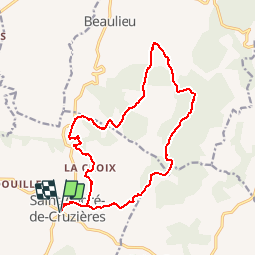
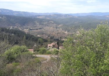
Trail Walking of 17.9 km to be discovered at Auvergne-Rhône-Alpes, Ardèche, Saint-André-de-Cruzières. This trail is proposed by tracegps.
Description
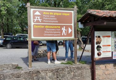
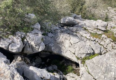
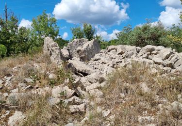
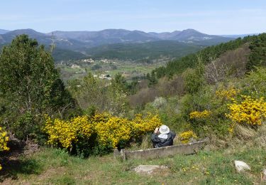
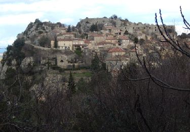
Remonter la rue principale de St André, passer à l'église puis sous le cimetière. Au Mas Rose se fier au GPS car le balisage est faible, puis monter sur une crête (limite de commune) et aller au Serre de Cruzières où le chemin épouse une longue crête. A un col (panneaux), quitter la crête vers Beaulieu et bifurquer vers Les Divols, cheminer dans les lapiaz puis rejoindre la D225,la suivre à gauche et la quitter en face. Trouver La Chapelette, bien suivre le balisage, retrouver la route un court instant et aller en direction de Lacroix et retrouver le chemin de l'aller au Mas Rose pour regagner le départ.
Positioning
Comments
Trails nearby
![Trail Walking Saint-Paul-le-Jeune - Du Viaduc de Doulovy au Fort de Banne - Saint Paul le Jeune - Photo](https://media.geolcdn.com/t/375/260/ext.jpg?maxdim=2&url=https%3A%2F%2Fservices.sitytrail.com%2FGeolivesWS%2FDownloadMedia.ashx%3FTrailID%3D317552%26Media%3D16802_6.jpg)
![Walking Walking](https://static1.geolcdn.com/sitytour/trail-icons/101.png)
Walking
![](/images/other/stat-length.png)
![](https://static1.geolcdn.com/siteimages/upload/files/16400158638029165_repeat_loop_refresh_sync_direction_icon.png)
![Trail Walking Saint-André-de-Cruzières - 07 chandouillet grotte cotepatiere sauvas peyrejol - Photo](https://media.geolcdn.com/t/375/260/f87b5d53-f27e-44e1-a082-e539e9102b98.jpg&format=jpg&maxdim=2)
![Walking Walking](https://static1.geolcdn.com/sitytour/trail-icons/101.png)
Walking
![](/images/other/stat-length.png)
![](https://static1.geolcdn.com/siteimages/upload/files/16400158638029165_repeat_loop_refresh_sync_direction_icon.png)
![Trail Walking Saint-Paul-le-Jeune - 07 les passages de voûtes au pont Doulovy 2 /02/25 - Photo](https://media.geolcdn.com/t/375/260/82fa3a1c-3766-4d3c-9be6-6015db6e1d7e.jpg&format=jpg&maxdim=2)
![Walking Walking](https://static1.geolcdn.com/sitytour/trail-icons/101.png)
Walking
![](/images/other/stat-length.png)
![](https://static1.geolcdn.com/siteimages/upload/files/16400158638029165_repeat_loop_refresh_sync_direction_icon.png)
![Trail Walking Courry - ARDECHE/GARD COURY Grotte de la cocaliere sentier de decouvertegrotte de la cocaliere - Photo](https://media.geolcdn.com/t/375/260/e5a0d0f9-58ff-4a07-a2b3-c16e7f6eaab2.jpg&format=jpg&maxdim=2)
![Walking Walking](https://static1.geolcdn.com/sitytour/trail-icons/101.png)
Walking
![](/images/other/stat-length.png)
![](https://static1.geolcdn.com/siteimages/upload/files/16400158638029165_repeat_loop_refresh_sync_direction_icon.png)
![Trail Walking Saint-André-de-Cruzières - CHADOUILLET - Photo](https://media.geolcdn.com/t/375/260/772623f8-cb56-4d04-9b3d-145b33c03c4b.jpeg&format=jpg&maxdim=2)
![Walking Walking](https://static1.geolcdn.com/sitytour/trail-icons/101.png)
Walking
![](/images/other/stat-length.png)
![](https://static1.geolcdn.com/siteimages/upload/files/16400158638029165_repeat_loop_refresh_sync_direction_icon.png)
![Trail Walking Saint-Paul-le-Jeune - Sentier des dolmens - Photo](https://media.geolcdn.com/t/375/260/12f79681-eaef-4f4e-bdc8-c82f9112e8f0.jpg&format=jpg&maxdim=2)
![Walking Walking](https://static1.geolcdn.com/sitytour/trail-icons/101.png)
Walking
![](/images/other/stat-length.png)
![](https://static1.geolcdn.com/siteimages/upload/files/16400158638029165_repeat_loop_refresh_sync_direction_icon.png)
![Trail Walking Saint-Paul-le-Jeune - St Paul Le Jeune-Chapelle St Sébastien 18km - Photo](https://media.geolcdn.com/t/375/260/cd1a704f-04ae-4412-9b27-5f3683850b1d.jpg&format=jpg&maxdim=2)
![Walking Walking](https://static1.geolcdn.com/sitytour/trail-icons/101.png)
Walking
![](/images/other/stat-length.png)
![](https://static1.geolcdn.com/siteimages/upload/files/16400158638029165_repeat_loop_refresh_sync_direction_icon.png)
![Trail Walking Saint-Paul-le-Jeune - St-Paul le jeune-Chapelle St Sébastien 18,5 km. - Photo](https://media.geolcdn.com/t/375/260/50065471-46bf-4681-b82d-c9dab470e89b.jpg&format=jpg&maxdim=2)
![Walking Walking](https://static1.geolcdn.com/sitytour/trail-icons/101.png)
Walking
![](/images/other/stat-length.png)
![](https://static1.geolcdn.com/siteimages/upload/files/16400158638029165_repeat_loop_refresh_sync_direction_icon.png)
![Trail Mountain bike Saint-Paul-le-Jeune - Du Viaduc de Doulovy au Fort de Banne - Saint Paul le Jeune - Photo](https://media.geolcdn.com/t/375/260/ext.jpg?maxdim=2&url=https%3A%2F%2Fservices.sitytrail.com%2FGeolivesWS%2FDownloadMedia.ashx%3FTrailID%3D317553%26Media%3D16802_6.jpg)
![Mountain bike Mountain bike](https://static1.geolcdn.com/sitytour/trail-icons/202.png)
Mountain bike
![](/images/other/stat-length.png)
![](https://static1.geolcdn.com/siteimages/upload/files/16400158638029165_repeat_loop_refresh_sync_direction_icon.png)