![](/images/other/stat-length.png)
![Trail Walking Sanilhac - Boucle du puits trouillier - Notre-Dame-de-Sanilhac - Photo](https://media.geolcdn.com/t/1900/400/ext.pjpeg?maxdim=2&url=https%3A%2F%2Fservices.sitytrail.com%2FGeolivesWS%2FDownloadMedia.ashx%3FTrailID%3D316973%26Media%3D16096_1.jpg)
Boucle du puits trouillier - Notre-Dame-de-Sanilhac
tracegps
User
![Length](/images/other/stat-length.png)
Length
8.2 km
![Max alt](https://static1.geolcdn.com/siteimages/upload/files/1508320355ic_sort_altitude_max_24dp.png)
Max alt
227 m
![Uphill gradient](https://static1.geolcdn.com/siteimages/upload/files/1508320355ic_sort_den_pos_24dp.png)
Uphill gradient
181 m
![Km-Effort](/images/other/stat-length.png)
Km-Effort
10.6 km
![Min alt](https://static1.geolcdn.com/siteimages/upload/files/1508320355ic_sort_altitude_min_24dp.png)
Min alt
141 m
![Downhill gradient](https://static1.geolcdn.com/siteimages/upload/files/1508320355ic_sort_den_neg_24dp.png)
Downhill gradient
181 m
![Boucle](https://static1.geolcdn.com/siteimages/upload/files/16400158638029165_repeat_loop_refresh_sync_direction_icon.png)
Boucle
Yes
Creation date :
2014-12-10 00:00:00.0
Updated on :
2014-12-10 00:00:00.0
![Walking](https://static1.geolcdn.com/sitytour/trail-icons/101.png)
2h00
Difficulty : Medium
![Scan this QR Code to open this trail in the SityTrail application](https://capi.geolives.com/qq0zvz2zws4bq2lad0pu/sitytour/trails/316973/qr.png?size=200)
FREE GPS app for hiking
About
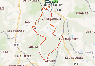
Trail Walking of 8.2 km to be discovered at New Aquitaine, Dordogne, Sanilhac. This trail is proposed by tracegps.
Description
Départ du parking avenue Jean et Léonce Petithomme Lafaye (D8). Le parcours principalement en campagne et forêt ne présente pas de difficulté particulière. Retrouvez le plan de l'ensemble des circuits sur le site de la commune de Notre-Dame-de-Sanilhac.
Positioning
Country:
France
Region :
New Aquitaine
Department/Province :
Dordogne
Municipality :
Sanilhac
Location:
Unknown
Start:(Dec)
Start:(UTM)
320347 ; 4999013 (31T) N.
Comments
Trails nearby
![Trail Walking Boulazac Isle Manoire - Atur - Photo](https://media.geolcdn.com/t/375/260/ext.jpg?maxdim=2&url=https%3A%2F%2Fstatic1.geolcdn.com%2Fsiteimages%2Fupload%2Ffiles%2F1553511878bg_sport_marche.png)
![Walking Walking](https://static1.geolcdn.com/sitytour/trail-icons/101.png)
Atur
Walking
Easy
(1)
Boulazac Isle Manoire,
New Aquitaine,
Dordogne,
France
![](/images/other/stat-length.png)
12.5 km | 15.8 km-effort
3h 23min
![](https://static1.geolcdn.com/siteimages/upload/files/16400158638029165_repeat_loop_refresh_sync_direction_icon.png)
Yes
![Trail Walking Sanilhac - ND de Sanilhac-Boucle du Pic - Photo](https://media.geolcdn.com/t/375/260/ext.jpg?maxdim=2&url=https%3A%2F%2Fstatic1.geolcdn.com%2Fsiteimages%2Fupload%2Ffiles%2F1553511878bg_sport_marche.png)
![Walking Walking](https://static1.geolcdn.com/sitytour/trail-icons/101.png)
ND de Sanilhac-Boucle du Pic
Walking
Easy
(2)
Sanilhac,
New Aquitaine,
Dordogne,
France
![](/images/other/stat-length.png)
7.3 km | 9 km-effort
1h 43min
![](https://static1.geolcdn.com/siteimages/upload/files/16400158638029165_repeat_loop_refresh_sync_direction_icon.png)
Yes
![Trail Walking Église-Neuve-de-Vergt - Eglise Neuve Vergt - Photo](https://media.geolcdn.com/t/375/260/c1219e7f-9e9a-411f-9248-f2ee6d3c3c64.jpg&format=jpg&maxdim=2)
![Walking Walking](https://static1.geolcdn.com/sitytour/trail-icons/101.png)
Eglise Neuve Vergt
Walking
Easy
Église-Neuve-de-Vergt,
New Aquitaine,
Dordogne,
France
![](/images/other/stat-length.png)
11.5 km | 14.3 km-effort
2h 36min
![](https://static1.geolcdn.com/siteimages/upload/files/16400158638029165_repeat_loop_refresh_sync_direction_icon.png)
Yes
![Trail Walking Creyssensac-et-Pissot - boucle creyssensac - Photo](https://media.geolcdn.com/t/375/260/ext.jpg?maxdim=2&url=https%3A%2F%2Fservices.sitytrail.com%2FGeolivesWS%2FDownloadMedia.ashx%3FTrailID%3D921085%26Media%3Dfix__20180311164914.jpg)
![Walking Walking](https://static1.geolcdn.com/sitytour/trail-icons/101.png)
boucle creyssensac
Walking
Easy
Creyssensac-et-Pissot,
New Aquitaine,
Dordogne,
France
![](/images/other/stat-length.png)
10.2 km | 12.7 km-effort
2h 14min
![](https://static1.geolcdn.com/siteimages/upload/files/16400158638029165_repeat_loop_refresh_sync_direction_icon.png)
Yes
![Trail Other activity Creyssensac-et-Pissot - étang des rosiers - Photo](https://media.geolcdn.com/t/375/260/ext.jpg?maxdim=2&url=https%3A%2F%2Fservices.sitytrail.com%2FGeolivesWS%2FDownloadMedia.ashx%3FTrailID%3D617235%26Media%3Dfix__20160730115705.jpg)
![Other activity Other activity](https://static1.geolcdn.com/sitytour/trail-icons/900.png)
étang des rosiers
Other activity
Very easy
Creyssensac-et-Pissot,
New Aquitaine,
Dordogne,
France
![](/images/other/stat-length.png)
11.1 km | 14.6 km-effort
3h 17min
![](https://static1.geolcdn.com/siteimages/upload/files/16400158638029165_repeat_loop_refresh_sync_direction_icon.png)
Yes
![Trail Walking Sanilhac - Notre Dame de Sanilhac ( longue) - Photo](https://media.geolcdn.com/t/375/260/ext.jpg?maxdim=2&url=https%3A%2F%2Fstatic1.geolcdn.com%2Fsiteimages%2Fupload%2Ffiles%2F1553511878bg_sport_marche.png)
![Walking Walking](https://static1.geolcdn.com/sitytour/trail-icons/101.png)
Notre Dame de Sanilhac ( longue)
Walking
Medium
Sanilhac,
New Aquitaine,
Dordogne,
France
![](/images/other/stat-length.png)
11.8 km | 15.1 km-effort
3h 14min
![](https://static1.geolcdn.com/siteimages/upload/files/16400158638029165_repeat_loop_refresh_sync_direction_icon.png)
Yes
![Trail Walking Coulounieix-Chamiers - boucle coulounieix - Photo](https://media.geolcdn.com/t/375/260/ext.jpg?maxdim=2&url=https%3A%2F%2Fstatic1.geolcdn.com%2Fsiteimages%2Fupload%2Ffiles%2F1553511878bg_sport_marche.png)
![Walking Walking](https://static1.geolcdn.com/sitytour/trail-icons/101.png)
boucle coulounieix
Walking
Easy
(1)
Coulounieix-Chamiers,
New Aquitaine,
Dordogne,
France
![](/images/other/stat-length.png)
12.7 km | 16.4 km-effort
2h 50min
![](https://static1.geolcdn.com/siteimages/upload/files/16400158638029165_repeat_loop_refresh_sync_direction_icon.png)
Yes
![Trail On foot Chalagnac - Boucle du Bas-Combin - Photo](https://media.geolcdn.com/t/375/260/ext.jpg?maxdim=2&url=https%3A%2F%2Fstatic1.geolcdn.com%2Fsiteimages%2Fupload%2Ffiles%2F1545311037marcheuse_200dpi.jpg)
![On foot On foot](https://static1.geolcdn.com/sitytour/trail-icons/100.png)
Boucle du Bas-Combin
On foot
Easy
Chalagnac,
New Aquitaine,
Dordogne,
France
![](/images/other/stat-length.png)
6.8 km | 9.1 km-effort
2h 4min
![](https://static1.geolcdn.com/siteimages/upload/files/16400158638029165_repeat_loop_refresh_sync_direction_icon.png)
Yes
![Trail On foot Creyssensac-et-Pissot - Boucle des écureuils - Photo](https://media.geolcdn.com/t/375/260/ext.jpg?maxdim=2&url=https%3A%2F%2Fstatic1.geolcdn.com%2Fsiteimages%2Fupload%2Ffiles%2F1545311037marcheuse_200dpi.jpg)
![On foot On foot](https://static1.geolcdn.com/sitytour/trail-icons/100.png)
Boucle des écureuils
On foot
Easy
Creyssensac-et-Pissot,
New Aquitaine,
Dordogne,
France
![](/images/other/stat-length.png)
7 km | 8.9 km-effort
2h 1min
![](https://static1.geolcdn.com/siteimages/upload/files/16400158638029165_repeat_loop_refresh_sync_direction_icon.png)
Yes