![](/images/other/stat-length.png)
![Trail Walking Auriol - cauvin bertagne roqueforcade - Photo](https://media.geolcdn.com/t/1900/400/bed442f2-5272-4d9b-a1a4-0f81c0197824.jpg&format=pjpeg&maxdim=2)
cauvin bertagne roqueforcade
cdanielrando
User
![Length](/images/other/stat-length.png)
![Max alt](https://static1.geolcdn.com/siteimages/upload/files/1508320355ic_sort_altitude_max_24dp.png)
![Uphill gradient](https://static1.geolcdn.com/siteimages/upload/files/1508320355ic_sort_den_pos_24dp.png)
![Km-Effort](/images/other/stat-length.png)
![Min alt](https://static1.geolcdn.com/siteimages/upload/files/1508320355ic_sort_altitude_min_24dp.png)
![Downhill gradient](https://static1.geolcdn.com/siteimages/upload/files/1508320355ic_sort_den_neg_24dp.png)
![Boucle](https://static1.geolcdn.com/siteimages/upload/files/16400158638029165_repeat_loop_refresh_sync_direction_icon.png)
![Walking](https://static1.geolcdn.com/sitytour/trail-icons/101.png)
4h52
Difficulty : Very difficult
![Scan this QR Code to open this trail in the SityTrail application](https://capi.geolives.com/qq0zvz2zws4bq2lad0pu/sitytour/trails/3169150/qr.png?size=200)
FREE GPS app for hiking
About
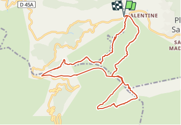
Trail Walking of 13.2 km to be discovered at Provence-Alpes-Côte d'Azur, Bouches-du-Rhône, Auriol. This trail is proposed by cdanielrando.
Description
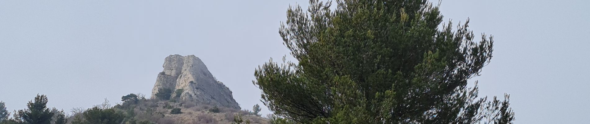
Pk départ arrivée sur la D2 à la limite du Var. Remonter le vallon du Cros pour arriver au col de Bertagne. Monter au pic de Bertagne par le sentier un peu raide mais bien balisé. Arrivé sur la route qui conduit au radar de l'aviation civile, la traverser et partie un peu vers l'est pour trouver le sentier qui conduit au col du Fauge. Descendre jusqu'à l'ancienne glacière et remonter au col de Bertagne puis, arrivé au col du Cros, Suivre l'indication col de l'Espigoulier par un beau chemin en balcon. Du col, monter au pied des dents de Roqueforcade et suivre le petit sentier au bas de la falaise par le nord pour remonter sur le plan des vaches. Partir au nord en direction de la tour de Cauvin sur laquelle on peut monter facilement et rejoindre le véhicule par une descente bien raide. Randonnée relativement courte mais qui offre des points de vue magnifiques.
Positioning
Comments
Trails nearby
![Trail Walking Gémenos - St Pons Le Fauge Glacière - Photo](https://media.geolcdn.com/t/375/260/ext.jpg?maxdim=2&url=https%3A%2F%2Fservices.sitytrail.com%2FGeolivesWS%2FDownloadMedia.ashx%3FTrailID%3D954893%26Media%3Dfix__20180430171638.jpg)
![Walking Walking](https://static1.geolcdn.com/sitytour/trail-icons/101.png)
Walking
![](/images/other/stat-length.png)
![](https://static1.geolcdn.com/siteimages/upload/files/16400158638029165_repeat_loop_refresh_sync_direction_icon.png)
![Trail Walking Gémenos - dent de roque forcade. cauvin.bertagne. 2 avril 2018 - Photo](https://media.geolcdn.com/t/375/260/ext.jpg?maxdim=2&url=https%3A%2F%2Fservices.sitytrail.com%2FGeolivesWS%2FDownloadMedia.ashx%3FTrailID%3D935467%26Media%3Dfix__20180402124207.jpg)
![Walking Walking](https://static1.geolcdn.com/sitytour/trail-icons/101.png)
Walking
![](/images/other/stat-length.png)
![](https://static1.geolcdn.com/siteimages/upload/files/16400158638029165_repeat_loop_refresh_sync_direction_icon.png)
![Trail Walking Auriol - la crete des infernets - Photo](https://media.geolcdn.com/t/375/260/ext.jpg?maxdim=2&url=https%3A%2F%2Fservices.sitytrail.com%2FGeolivesWS%2FDownloadMedia.ashx%3FTrailID%3D867921%26Media%3Dfix__20171126111949.jpg)
![Walking Walking](https://static1.geolcdn.com/sitytour/trail-icons/101.png)
Walking
![](/images/other/stat-length.png)
![](https://static1.geolcdn.com/siteimages/upload/files/16400158638029165_repeat_loop_refresh_sync_direction_icon.png)
![Trail Walking Gémenos - autour de Saint pons - Photo](https://media.geolcdn.com/t/375/260/ext.jpg?maxdim=2&url=https%3A%2F%2Fservices.sitytrail.com%2FGeolivesWS%2FDownloadMedia.ashx%3FTrailID%3D723506%26Media%3Dfix__20170330154755.jpg)
![Walking Walking](https://static1.geolcdn.com/sitytour/trail-icons/101.png)
Walking
![](/images/other/stat-length.png)
![](https://static1.geolcdn.com/siteimages/upload/files/16400158638029165_repeat_loop_refresh_sync_direction_icon.png)
![Trail Walking Gémenos - Autour des Dents de Roque Forcade, Tour de Cauvin - Photo](https://media.geolcdn.com/t/375/260/ext.jpg?maxdim=2&url=https%3A%2F%2Fservices.sitytrail.com%2FGeolivesWS%2FDownloadMedia.ashx%3FTrailID%3D107626%26Media%3D12610_1.jpg)
![Walking Walking](https://static1.geolcdn.com/sitytour/trail-icons/101.png)
Walking
![](/images/other/stat-length.png)
![](https://static1.geolcdn.com/siteimages/upload/files/16400158638029165_repeat_loop_refresh_sync_direction_icon.png)
![Trail Mountain bike Gémenos - Gémenos - La Grande Baume - Photo](https://media.geolcdn.com/t/375/260/ext.jpg?maxdim=2&url=https%3A%2F%2Fservices.sitytrail.com%2FGeolivesWS%2FDownloadMedia.ashx%3FTrailID%3D104196%26Media%3D7328_1.jpg)
![Mountain bike Mountain bike](https://static1.geolcdn.com/sitytour/trail-icons/202.png)
Mountain bike
![](/images/other/stat-length.png)
![](https://static1.geolcdn.com/siteimages/upload/files/16400158638029165_repeat_loop_refresh_sync_direction_icon.png)
![Trail Walking Plan-d'Aups-Sainte-Baume - La Grotte aux oiseaux - Plan d'Aups - Photo](https://media.geolcdn.com/t/375/260/ext.jpg?maxdim=2&url=https%3A%2F%2Fservices.sitytrail.com%2FGeolivesWS%2FDownloadMedia.ashx%3FTrailID%3D103826%26Media%3D6600_1.jpg)
![Walking Walking](https://static1.geolcdn.com/sitytour/trail-icons/101.png)
Walking
![](/images/other/stat-length.png)
![](https://static1.geolcdn.com/siteimages/upload/files/16400158638029165_repeat_loop_refresh_sync_direction_icon.png)
![Trail Walking Gémenos - Parc de St Pons anc. Glacière - Photo](https://media.geolcdn.com/t/375/260/01d544fc-e25f-41ba-b83a-9276d30a703d.jpg&format=jpg&maxdim=2)
![Walking Walking](https://static1.geolcdn.com/sitytour/trail-icons/101.png)
Walking
![](/images/other/stat-length.png)
![](https://static1.geolcdn.com/siteimages/upload/files/16400158638029165_repeat_loop_refresh_sync_direction_icon.png)
![Trail Walking Saint-Zacharie - Sources des Nayes - Photo](https://media.geolcdn.com/t/375/260/f10876bf-7b9c-4295-a050-83953c85f7a8.jpg&format=jpg&maxdim=2)
![Walking Walking](https://static1.geolcdn.com/sitytour/trail-icons/101.png)
Walking
![](/images/other/stat-length.png)
![](https://static1.geolcdn.com/siteimages/upload/files/16400158638029165_repeat_loop_refresh_sync_direction_icon.png)