![](/images/other/stat-length.png)
![Trail Walking Cappy - Les Champs Muraine - Cappy - Photo](https://media.geolcdn.com/t/1900/400/ext.pjpeg?maxdim=2&url=https%3A%2F%2Fservices.sitytrail.com%2FGeolivesWS%2FDownloadMedia.ashx%3FTrailID%3D316902%26Media%3D15996_1.jpg)
Les Champs Muraine - Cappy
tracegps
User
![Length](/images/other/stat-length.png)
Length
9.9 km
![Max alt](https://static1.geolcdn.com/siteimages/upload/files/1508320355ic_sort_altitude_max_24dp.png)
Max alt
91 m
![Uphill gradient](https://static1.geolcdn.com/siteimages/upload/files/1508320355ic_sort_den_pos_24dp.png)
Uphill gradient
153 m
![Km-Effort](/images/other/stat-length.png)
Km-Effort
11.9 km
![Min alt](https://static1.geolcdn.com/siteimages/upload/files/1508320355ic_sort_altitude_min_24dp.png)
Min alt
41 m
![Downhill gradient](https://static1.geolcdn.com/siteimages/upload/files/1508320355ic_sort_den_neg_24dp.png)
Downhill gradient
152 m
![Boucle](https://static1.geolcdn.com/siteimages/upload/files/16400158638029165_repeat_loop_refresh_sync_direction_icon.png)
Boucle
Yes
Creation date :
2014-12-10 00:00:00.0
Updated on :
2014-12-10 00:00:00.0
![Walking](https://static1.geolcdn.com/sitytour/trail-icons/101.png)
2h15
Difficulty : Medium
![Scan this QR Code to open this trail in the SityTrail application](https://capi.geolives.com/qq0zvz2zws4bq2lad0pu/sitytour/trails/316902/qr.png?size=200)
FREE GPS app for hiking
About
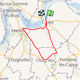
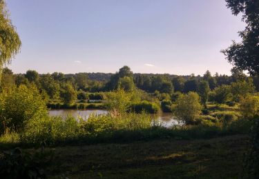
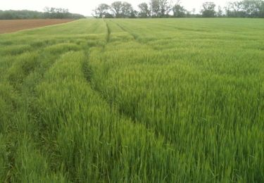
Trail Walking of 9.9 km to be discovered at Hauts-de-France, Somme, Cappy. This trail is proposed by tracegps.
Description
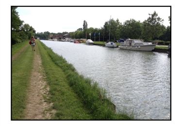
Cappy serait-elle plus ancienne qu'Amiens? Un sceau médiéval y fut trouvé, lors de la construction de la mairie. Il remonte à 1228. Alors, prenez garde où vous mettez les pieds!
Positioning
Country:
France
Region :
Hauts-de-France
Department/Province :
Somme
Municipality :
Cappy
Location:
Unknown
Start:(Dec)
Start:(UTM)
482455 ; 5530715 (31U) N.
Comments
Trails nearby
![Trail Walking Cappy - Les Marais de Suzanne - Cappy - Photo](https://media.geolcdn.com/t/375/260/ext.jpg?maxdim=2&url=https%3A%2F%2Fservices.sitytrail.com%2FGeolivesWS%2FDownloadMedia.ashx%3FTrailID%3D318046%26Media%3D17516_6.jpg)
![Walking Walking](https://static1.geolcdn.com/sitytour/trail-icons/101.png)
Les Marais de Suzanne - Cappy
Walking
Medium
(1)
Cappy,
Hauts-de-France,
Somme,
France
![](/images/other/stat-length.png)
11.2 km | 13.2 km-effort
2h 45min
![](https://static1.geolcdn.com/siteimages/upload/files/16400158638029165_repeat_loop_refresh_sync_direction_icon.png)
Yes
![Trail Walking Frise - La Montagne de Frise - Photo](https://media.geolcdn.com/t/375/260/ext.jpg?maxdim=2&url=https%3A%2F%2Fservices.sitytrail.com%2FGeolivesWS%2FDownloadMedia.ashx%3FTrailID%3D191478%26Media%3D15070_3.jpg)
![Walking Walking](https://static1.geolcdn.com/sitytour/trail-icons/101.png)
La Montagne de Frise
Walking
Medium
(1)
Frise,
Hauts-de-France,
Somme,
France
![](/images/other/stat-length.png)
2.2 km | 2.8 km-effort
49min
![](https://static1.geolcdn.com/siteimages/upload/files/16400158638029165_repeat_loop_refresh_sync_direction_icon.png)
Yes
![Trail On foot Cappy - Les Royards - Photo](https://media.geolcdn.com/t/375/260/61c5a7bb-5adb-45c2-89f4-300458b09b65.jpeg&format=jpg&maxdim=2)
![On foot On foot](https://static1.geolcdn.com/sitytour/trail-icons/100.png)
![Trail Walking Curlu - tour des étangs de curlu - Photo](https://media.geolcdn.com/t/375/260/2b57625a-664a-4009-9f8e-b4056a815ff7.jpg&format=jpg&maxdim=2)
![Walking Walking](https://static1.geolcdn.com/sitytour/trail-icons/101.png)
tour des étangs de curlu
Walking
Very easy
Curlu,
Hauts-de-France,
Somme,
France
![](/images/other/stat-length.png)
10.5 km | 11.6 km-effort
2h 41min
![](https://static1.geolcdn.com/siteimages/upload/files/16400158638029165_repeat_loop_refresh_sync_direction_icon.png)
Yes
![Trail Walking Curlu - Autour des étangs de Curlu et Feuillères - Photo](https://media.geolcdn.com/t/375/260/ext.jpg?maxdim=2&url=https%3A%2F%2Fservices.sitytrail.com%2FGeolivesWS%2FDownloadMedia.ashx%3FTrailID%3D991523%26Media%3Dfix__20180622190908.jpg)
![Walking Walking](https://static1.geolcdn.com/sitytour/trail-icons/101.png)
Autour des étangs de Curlu et Feuillères
Walking
Easy
(1)
Curlu,
Hauts-de-France,
Somme,
France
![](/images/other/stat-length.png)
11.6 km | 12.7 km-effort
3h 11min
![](https://static1.geolcdn.com/siteimages/upload/files/16400158638029165_repeat_loop_refresh_sync_direction_icon.png)
Yes
![Trail Other activity Éclusier-Vaux - Vaux - Marais de la Somme - Photo](https://media.geolcdn.com/t/375/260/ext.jpg?maxdim=2&url=https%3A%2F%2Fservices.sitytrail.com%2FGeolivesWS%2FDownloadMedia.ashx%3FTrailID%3D697712%26Media%3D20170213172513.jpg)
![Other activity Other activity](https://static1.geolcdn.com/sitytour/trail-icons/900.png)
Vaux - Marais de la Somme
Other activity
Very easy
Éclusier-Vaux,
Hauts-de-France,
Somme,
France
![](/images/other/stat-length.png)
8.7 km | 10.1 km-effort
2h 13min
![](https://static1.geolcdn.com/siteimages/upload/files/16400158638029165_repeat_loop_refresh_sync_direction_icon.png)
Yes
![Trail Walking Frise - montagne de frise - Photo](https://media.geolcdn.com/t/375/260/ext.jpg?maxdim=2&url=https%3A%2F%2Fstatic1.geolcdn.com%2Fsiteimages%2Fupload%2Ffiles%2F1553511878bg_sport_marche.png)
![Walking Walking](https://static1.geolcdn.com/sitytour/trail-icons/101.png)
montagne de frise
Walking
Medium
(1)
Frise,
Hauts-de-France,
Somme,
France
![](/images/other/stat-length.png)
2 km | 2.5 km-effort
1h 0min
![](https://static1.geolcdn.com/siteimages/upload/files/16400158638029165_repeat_loop_refresh_sync_direction_icon.png)
Yes
![Trail Walking Curlu - Le chemin des Automitrailleuses - Curlu - Photo](https://media.geolcdn.com/t/375/260/ext.jpg?maxdim=2&url=https%3A%2F%2Fservices.sitytrail.com%2FGeolivesWS%2FDownloadMedia.ashx%3FTrailID%3D172267%26Media%3D13579_6.jpg)
![Walking Walking](https://static1.geolcdn.com/sitytour/trail-icons/101.png)
Le chemin des Automitrailleuses - Curlu
Walking
Medium
(1)
Curlu,
Hauts-de-France,
Somme,
France
![](/images/other/stat-length.png)
11 km | 12 km-effort
3h 19min
![](https://static1.geolcdn.com/siteimages/upload/files/16400158638029165_repeat_loop_refresh_sync_direction_icon.png)
Yes
![Trail Walking Chuignolles - CHUIGNOLLES - 80 Circuit du gros canon - Photo](https://media.geolcdn.com/t/375/260/9b9d871f-5b11-44ae-ade1-6d8bca7d07de.jpg&format=jpg&maxdim=2)
![Walking Walking](https://static1.geolcdn.com/sitytour/trail-icons/101.png)
CHUIGNOLLES - 80 Circuit du gros canon
Walking
Medium
Chuignolles,
Hauts-de-France,
Somme,
France
![](/images/other/stat-length.png)
9.3 km | 11.2 km-effort
2h 33min
![](https://static1.geolcdn.com/siteimages/upload/files/16400158638029165_repeat_loop_refresh_sync_direction_icon.png)
Yes