![](/images/other/stat-length.png)
![Trail Running Ploemel - Tour de Ploemel - Ploemel - Photo](https://media.geolcdn.com/t/1900/400/ext.pjpeg?maxdim=2&url=https%3A%2F%2Fservices.sitytrail.com%2FGeolivesWS%2FDownloadMedia.ashx%3FTrailID%3D316894%26Media%3D15980_5.jpg)
Tour de Ploemel - Ploemel
tracegps
User
![Length](/images/other/stat-length.png)
Length
16.2 km
![Max alt](https://static1.geolcdn.com/siteimages/upload/files/1508320355ic_sort_altitude_max_24dp.png)
Max alt
42 m
![Uphill gradient](https://static1.geolcdn.com/siteimages/upload/files/1508320355ic_sort_den_pos_24dp.png)
Uphill gradient
125 m
![Km-Effort](/images/other/stat-length.png)
Km-Effort
17.8 km
![Min alt](https://static1.geolcdn.com/siteimages/upload/files/1508320355ic_sort_altitude_min_24dp.png)
Min alt
17 m
![Downhill gradient](https://static1.geolcdn.com/siteimages/upload/files/1508320355ic_sort_den_neg_24dp.png)
Downhill gradient
124 m
![Boucle](https://static1.geolcdn.com/siteimages/upload/files/16400158638029165_repeat_loop_refresh_sync_direction_icon.png)
Boucle
Yes
Creation date :
2014-12-10 00:00:00.0
Updated on :
2014-12-10 00:00:00.0
![Running](https://static1.geolcdn.com/sitytour/trail-icons/103.png)
1h30
Difficulty : Difficult
![Scan this QR Code to open this trail in the SityTrail application](https://capi.geolives.com/qq0zvz2zws4bq2lad0pu/sitytour/trails/316894/qr.png?size=200)
FREE GPS app for hiking
About
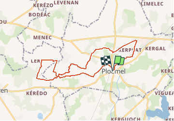
Trail Running of 16.2 km to be discovered at Brittany, Morbihan, Ploemel. This trail is proposed by tracegps.
Description
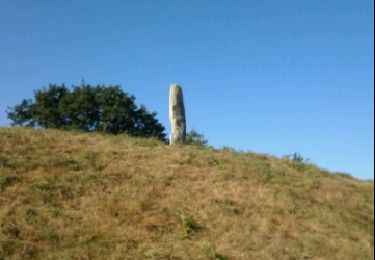
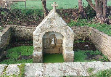
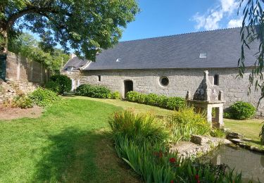
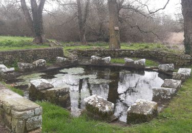
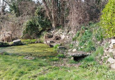
Parcours essentiellement en sous-bois qui fait une boucle autour de Ploemel et de St Laurent. On croise quelques chapelles, croix du 1er siècle.
Positioning
Country:
France
Region :
Brittany
Department/Province :
Morbihan
Municipality :
Ploemel
Location:
Unknown
Start:(Dec)
Start:(UTM)
494566 ; 5277481 (30T) N.
Comments
Trails nearby
![Trail Running Ploemel - Ploemel stirwen - Photo](https://media.geolcdn.com/t/375/260/ext.jpg?maxdim=2&url=https%3A%2F%2Fservices.sitytrail.com%2FGeolivesWS%2FDownloadMedia.ashx%3FTrailID%3D215171%26Media%3Dfix__20130820105024.jpg)
![Running Running](https://static1.geolcdn.com/sitytour/trail-icons/103.png)
Ploemel stirwen
Running
Medium
(3)
Ploemel,
Brittany,
Morbihan,
France
![](/images/other/stat-length.png)
9 km | 10.1 km-effort
1h 40min
![](https://static1.geolcdn.com/siteimages/upload/files/16400158638029165_repeat_loop_refresh_sync_direction_icon.png)
Yes
![Trail Walking Ploemel - Ploemel Kaer gaer - Photo](https://media.geolcdn.com/t/375/260/ext.jpg?maxdim=2&url=https%3A%2F%2Fservices.sitytrail.com%2FGeolivesWS%2FDownloadMedia.ashx%3FTrailID%3D201949%26Media%3Dfix__20130701104212.jpg)
![Walking Walking](https://static1.geolcdn.com/sitytour/trail-icons/101.png)
Ploemel Kaer gaer
Walking
Medium
(1)
Ploemel,
Brittany,
Morbihan,
France
![](/images/other/stat-length.png)
9.1 km | 10.1 km-effort
1h 45min
![](https://static1.geolcdn.com/siteimages/upload/files/16400158638029165_repeat_loop_refresh_sync_direction_icon.png)
Yes
![Trail On foot Plouharnel - Circuit des Abbayes - Photo](https://media.geolcdn.com/t/375/260/dca929bf-5e72-45e1-98bd-dbdbc141c047.jpeg&format=jpg&maxdim=2)
![On foot On foot](https://static1.geolcdn.com/sitytour/trail-icons/100.png)
Circuit des Abbayes
On foot
Easy
Plouharnel,
Brittany,
Morbihan,
France
![](/images/other/stat-length.png)
8 km | 8.7 km-effort
1h 58min
![](https://static1.geolcdn.com/siteimages/upload/files/16400158638029165_repeat_loop_refresh_sync_direction_icon.png)
Yes
![Trail Other activity Ploemel - Ty Bocquet 19-11-16 . - Photo](https://media.geolcdn.com/t/375/260/ext.jpg?maxdim=2&url=https%3A%2F%2Fstatic1.geolcdn.com%2Fsiteimages%2Fupload%2Ffiles%2F1545311037marcheuse_200dpi.jpg)
![Other activity Other activity](https://static1.geolcdn.com/sitytour/trail-icons/900.png)
Ty Bocquet 19-11-16 .
Other activity
Very easy
(1)
Ploemel,
Brittany,
Morbihan,
France
![](/images/other/stat-length.png)
5.1 km | 5.5 km-effort
57min
![](https://static1.geolcdn.com/siteimages/upload/files/16400158638029165_repeat_loop_refresh_sync_direction_icon.png)
Yes
![Trail Walking Locoal-Mendon - PR_56_Locoal-Mendon_AA_01_Circuit1b_Ty-Er-Chir-Kernous_20240107 - Photo](https://media.geolcdn.com/t/375/260/a43d6fd1-c479-4c9b-9e22-a3820e687e52.jpg&format=jpg&maxdim=2)
![Walking Walking](https://static1.geolcdn.com/sitytour/trail-icons/101.png)
PR_56_Locoal-Mendon_AA_01_Circuit1b_Ty-Er-Chir-Kernous_20240107
Walking
Easy
Locoal-Mendon,
Brittany,
Morbihan,
France
![](/images/other/stat-length.png)
7.8 km | 8.9 km-effort
1h 46min
![](https://static1.geolcdn.com/siteimages/upload/files/16400158638029165_repeat_loop_refresh_sync_direction_icon.png)
Yes
![Trail Walking Ploemel - PR_56_Ploemel_BA_02_Circuit1b_Chapelles-Et-Fontaines_20230810 - Photo](https://media.geolcdn.com/t/375/260/eb2cbc2d-eda2-4a81-941a-e994e46cd707.jpg&format=jpg&maxdim=2)
![Walking Walking](https://static1.geolcdn.com/sitytour/trail-icons/101.png)
PR_56_Ploemel_BA_02_Circuit1b_Chapelles-Et-Fontaines_20230810
Walking
Very easy
Ploemel,
Brittany,
Morbihan,
France
![](/images/other/stat-length.png)
10.3 km | 11.3 km-effort
2h 2min
![](https://static1.geolcdn.com/siteimages/upload/files/16400158638029165_repeat_loop_refresh_sync_direction_icon.png)
Yes
![Trail Walking Ploemel - PR_56_Ploemel_AA_01_Circuit1b_Tro-Plenuer_20230806 - Photo](https://media.geolcdn.com/t/375/260/3c1c29e6-2dc2-41ec-9b71-4646b52d6ad3.jpg&format=jpg&maxdim=2)
![Walking Walking](https://static1.geolcdn.com/sitytour/trail-icons/101.png)
PR_56_Ploemel_AA_01_Circuit1b_Tro-Plenuer_20230806
Walking
Medium
Ploemel,
Brittany,
Morbihan,
France
![](/images/other/stat-length.png)
7.6 km | 8.5 km-effort
1h 55min
![](https://static1.geolcdn.com/siteimages/upload/files/16400158638029165_repeat_loop_refresh_sync_direction_icon.png)
Yes
![Trail Walking Plouharnel - Kerhelkegant,Sainte Barbe,mer - Photo](https://media.geolcdn.com/t/375/260/47116aa8-1039-40d7-8705-18884dc57f5e.jpg&format=jpg&maxdim=2)
![Walking Walking](https://static1.geolcdn.com/sitytour/trail-icons/101.png)
Kerhelkegant,Sainte Barbe,mer
Walking
Very easy
Plouharnel,
Brittany,
Morbihan,
France
![](/images/other/stat-length.png)
8.3 km | 9 km-effort
1h 57min
![](https://static1.geolcdn.com/siteimages/upload/files/16400158638029165_repeat_loop_refresh_sync_direction_icon.png)
Yes
![Trail Walking Plouharnel - PR_56_Plouharnel_BA_02_Circuit1b_Crucuno_20230303 - Photo](https://media.geolcdn.com/t/375/260/3b6d879d-549b-4f20-b44b-ac2eac3d8f83.jpg&format=jpg&maxdim=2)
![Walking Walking](https://static1.geolcdn.com/sitytour/trail-icons/101.png)
PR_56_Plouharnel_BA_02_Circuit1b_Crucuno_20230303
Walking
Very easy
Plouharnel,
Brittany,
Morbihan,
France
![](/images/other/stat-length.png)
8.7 km | 9.4 km-effort
2h 1min
![](https://static1.geolcdn.com/siteimages/upload/files/16400158638029165_repeat_loop_refresh_sync_direction_icon.png)
Yes