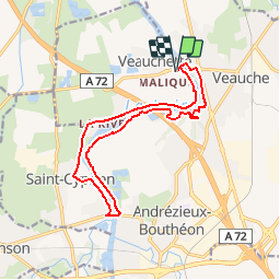
![](/images/other/stat-length.png)
![Trail Mountain bike Veauchette - Du Barrage de Villerest au Barrage de Grangent en 10 boucles / Boucle N° 08 : Pont de Veauche - Pont d'Andrézieux - Photo](https://media.geolcdn.com/t/1900/400/ext.pjpeg?maxdim=2&url=https%3A%2F%2Fservices.sitytrail.com%2FGeolivesWS%2FDownloadMedia.ashx%3FTrailID%3D316885%26Media%3D15969_6.jpg)
Du Barrage de Villerest au Barrage de Grangent en 10 boucles / Boucle N° 08 : Pont de Veauche - Pont d'Andrézieux
tracegps
User
![Length](/images/other/stat-length.png)
![Max alt](https://static1.geolcdn.com/siteimages/upload/files/1508320355ic_sort_altitude_max_24dp.png)
![Uphill gradient](https://static1.geolcdn.com/siteimages/upload/files/1508320355ic_sort_den_pos_24dp.png)
![Km-Effort](/images/other/stat-length.png)
![Min alt](https://static1.geolcdn.com/siteimages/upload/files/1508320355ic_sort_altitude_min_24dp.png)
![Downhill gradient](https://static1.geolcdn.com/siteimages/upload/files/1508320355ic_sort_den_neg_24dp.png)
![Boucle](https://static1.geolcdn.com/siteimages/upload/files/16400158638029165_repeat_loop_refresh_sync_direction_icon.png)
![Mountain bike](https://static1.geolcdn.com/sitytour/trail-icons/202.png)
1h45
Difficulty : Medium
![Scan this QR Code to open this trail in the SityTrail application](https://capi.geolives.com/qq0zvz2zws4bq2lad0pu/sitytour/trails/316885/qr.png?size=200)
FREE GPS app for hiking
About
Trail Mountain bike of 15 km to be discovered at Auvergne-Rhône-Alpes, Loire, Veauchette. This trail is proposed by tracegps.
Description
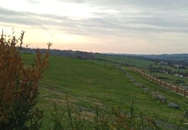
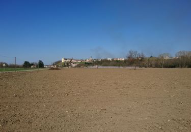
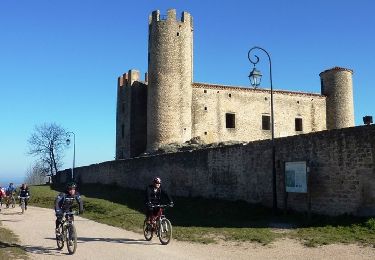
Parking et départ proche de l’église de Veauchette. Franchissant la Loire par le pont de Veauche et celui d’Andrézieux, ce circuit fait découvrir l’église de Veauchette, les bords de Loire, le pont de l’A72, le pont d’Andrézieux et ses restaurants gastronomiques à proximité, le sentier ornithologique d’Andrézieux-Bouthéon, les cultures maraichères et le château de Bouthéon. Le parcours est facile et très roulant, il emprunte de nombreux single-tracks ludiques qui serpentent entre la Loire et les étangs tout en traversant de nombreux sous-bois. Certains sentiers peuvent s’avérer meubles et sableux. Sur le retour, après la station de pompage, le sentier en sous-bois est très agréable jusqu’à la passerelle en bois, la portion suivante jusqu’aux escaliers en rondins s’avère grasse, humide et assez délicate (arbres en travers) puis la montée raide pour atteindre les premières maisons de Veauche/Les Volons, aux marches en rondins, nécessitera certainement de pousser son VTT.
Positioning
Comments
Trails nearby
![Trail Walking Saint-Bonnet-les-Oules - Saint-Bonnet-les-Oules du 26-12-2022 - Photo](https://media.geolcdn.com/t/375/260/b0909c52-48d0-4fb3-a021-6e2066fe45fd.jpg&format=jpg&maxdim=2)
![Walking Walking](https://static1.geolcdn.com/sitytour/trail-icons/101.png)
Walking
![](/images/other/stat-length.png)
![](https://static1.geolcdn.com/siteimages/upload/files/16400158638029165_repeat_loop_refresh_sync_direction_icon.png)
![Trail Walking Andrézieux-Bouthéon - autour de Boutheon - Photo](https://media.geolcdn.com/t/375/260/2650ae89-7750-43af-bfc7-bc43f795b3df.jpg&format=jpg&maxdim=2)
![Walking Walking](https://static1.geolcdn.com/sitytour/trail-icons/101.png)
Walking
![](/images/other/stat-length.png)
![](https://static1.geolcdn.com/siteimages/upload/files/16400158638029165_repeat_loop_refresh_sync_direction_icon.png)
![Trail Mountain bike Veauche - Par Monts et par Veauche (2014-VTT-70km) - Veauche - Photo](https://media.geolcdn.com/t/375/260/ext.jpg?maxdim=2&url=https%3A%2F%2Fservices.sitytrail.com%2FGeolivesWS%2FDownloadMedia.ashx%3FTrailID%3D318103%26Media%3D17562_6.jpg)
![Mountain bike Mountain bike](https://static1.geolcdn.com/sitytour/trail-icons/202.png)
Mountain bike
![](/images/other/stat-length.png)
![](https://static1.geolcdn.com/siteimages/upload/files/16400158638029165_repeat_loop_refresh_sync_direction_icon.png)
![Trail Mountain bike Veauche - Par Monts et par Veauche (2014-VTT-45km) - Veauche - Photo](https://media.geolcdn.com/t/375/260/ext.jpg?maxdim=2&url=https%3A%2F%2Fservices.sitytrail.com%2FGeolivesWS%2FDownloadMedia.ashx%3FTrailID%3D318102%26Media%3D17561_6.jpg)
![Mountain bike Mountain bike](https://static1.geolcdn.com/sitytour/trail-icons/202.png)
Mountain bike
![](/images/other/stat-length.png)
![](https://static1.geolcdn.com/siteimages/upload/files/16400158638029165_repeat_loop_refresh_sync_direction_icon.png)
![Trail Mountain bike Andrézieux-Bouthéon - 14ème Envolée Verte (2014-VTT-60 km) - Andrézieux-Bouthéon - Photo](https://media.geolcdn.com/t/375/260/ext.jpg?maxdim=2&url=https%3A%2F%2Fservices.sitytrail.com%2FGeolivesWS%2FDownloadMedia.ashx%3FTrailID%3D317644%26Media%3D16917_5.jpg)
![Mountain bike Mountain bike](https://static1.geolcdn.com/sitytour/trail-icons/202.png)
Mountain bike
![](/images/other/stat-length.png)
![](https://static1.geolcdn.com/siteimages/upload/files/16400158638029165_repeat_loop_refresh_sync_direction_icon.png)
![Trail Running Saint-Galmier - La Rose de Saint-Galmier - Photo](https://media.geolcdn.com/t/375/260/ext.jpg?maxdim=2&url=https%3A%2F%2Fservices.sitytrail.com%2FGeolivesWS%2FDownloadMedia.ashx%3FTrailID%3D317008%26Media%3D16145_6.jpg)
![Running Running](https://static1.geolcdn.com/sitytour/trail-icons/103.png)
Running
![](/images/other/stat-length.png)
![](https://static1.geolcdn.com/siteimages/upload/files/16400158638029165_repeat_loop_refresh_sync_direction_icon.png)
![Trail Walking Saint-Galmier - La Rose de Saint-Galmier - Photo](https://media.geolcdn.com/t/375/260/ext.jpg?maxdim=2&url=https%3A%2F%2Fservices.sitytrail.com%2FGeolivesWS%2FDownloadMedia.ashx%3FTrailID%3D317007%26Media%3D16145_6.jpg)
![Walking Walking](https://static1.geolcdn.com/sitytour/trail-icons/101.png)
Walking
![](/images/other/stat-length.png)
![](https://static1.geolcdn.com/siteimages/upload/files/16400158638029165_repeat_loop_refresh_sync_direction_icon.png)
![Trail Mountain bike Saint-Galmier - Remake VTT de Par Monts et par Veauche 2013 - Saint-Galmier - Photo](https://media.geolcdn.com/t/375/260/ext.jpg?maxdim=2&url=https%3A%2F%2Fservices.sitytrail.com%2FGeolivesWS%2FDownloadMedia.ashx%3FTrailID%3D316994%26Media%3D16127_3.jpg)
![Mountain bike Mountain bike](https://static1.geolcdn.com/sitytour/trail-icons/202.png)
Mountain bike
![](/images/other/stat-length.png)
![](https://static1.geolcdn.com/siteimages/upload/files/16400158638029165_repeat_loop_refresh_sync_direction_icon.png)
![Trail Mountain bike Saint-Cyprien - Du Barrage de Villerest au Barrage de Grangent en 10 boucles / Boucle N° 09 : Pont d'Andrézieux - Pont de Saint-Just-Saint-Rambert - Photo](https://media.geolcdn.com/t/375/260/ext.jpg?maxdim=2&url=https%3A%2F%2Fservices.sitytrail.com%2FGeolivesWS%2FDownloadMedia.ashx%3FTrailID%3D316887%26Media%3D15970_6.jpg)
![Mountain bike Mountain bike](https://static1.geolcdn.com/sitytour/trail-icons/202.png)
Mountain bike
![](/images/other/stat-length.png)
![](https://static1.geolcdn.com/siteimages/upload/files/16400158638029165_repeat_loop_refresh_sync_direction_icon.png)