![](/images/other/stat-length.png)
![Trail Mountain bike Cordelle - Du Barrage de Villerest au Barrage de Grangent en 10 boucles / Boucle N° 02 : Pont de Presle - Pont de La Vourdiat - Photo](https://media.geolcdn.com/t/1900/400/ext.pjpeg?maxdim=2&url=https%3A%2F%2Fservices.sitytrail.com%2FGeolivesWS%2FDownloadMedia.ashx%3FTrailID%3D316879%26Media%3D15963_6.jpg)
Du Barrage de Villerest au Barrage de Grangent en 10 boucles / Boucle N° 02 : Pont de Presle - Pont de La Vourdiat
tracegps
User
![Length](/images/other/stat-length.png)
![Max alt](https://static1.geolcdn.com/siteimages/upload/files/1508320355ic_sort_altitude_max_24dp.png)
![Uphill gradient](https://static1.geolcdn.com/siteimages/upload/files/1508320355ic_sort_den_pos_24dp.png)
![Km-Effort](/images/other/stat-length.png)
![Min alt](https://static1.geolcdn.com/siteimages/upload/files/1508320355ic_sort_altitude_min_24dp.png)
![Downhill gradient](https://static1.geolcdn.com/siteimages/upload/files/1508320355ic_sort_den_neg_24dp.png)
![Boucle](https://static1.geolcdn.com/siteimages/upload/files/16400158638029165_repeat_loop_refresh_sync_direction_icon.png)
![Mountain bike](https://static1.geolcdn.com/sitytour/trail-icons/202.png)
3h15
Difficulty : Very difficult
![Scan this QR Code to open this trail in the SityTrail application](https://capi.geolives.com/qq0zvz2zws4bq2lad0pu/sitytour/trails/316879/qr.png?size=200)
FREE GPS app for hiking
About
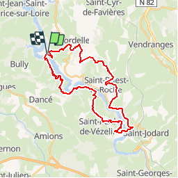
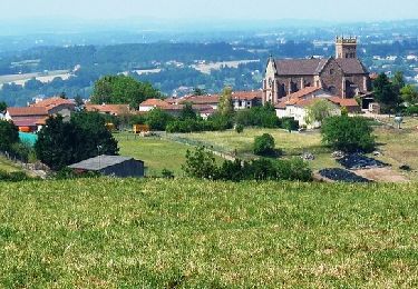
Trail Mountain bike of 32 km to be discovered at Auvergne-Rhône-Alpes, Loire, Cordelle. This trail is proposed by tracegps.
Description
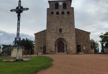
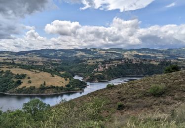
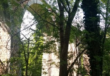
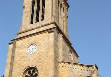
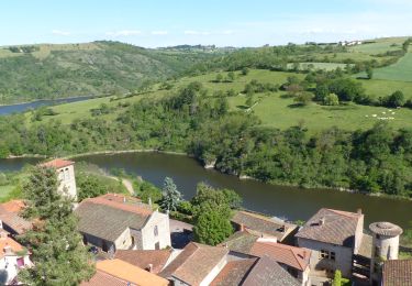
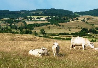
Parking et départ proche du pont de Presle. Franchissant la Loire par le pont de Presle et celui de La Vourdiat, ce circuit fait découvrir les gorges de la Loire en empruntant les sentiers les plus sauvages et les plus reculés du secteur, le site de "Pet de l'âne" (belvédère), la presqu’ile de Mars (plus grand méandre de la Loire), le camping d’Arpheuilles, le pont de La Vourdiat, le château de La Roche (site remarquable), le village de Saint-Priest-la-Roche et les nombreux hameaux traversés. Le parcours est plutôt physique et technique, avec de beaux passages près du fleuve dans les gorges de la Loire. Les panoramas sont absolument splendides, alors ne pas hésiter à faire quelques pauses afin de contempler les jolis coups d’œil sur tous les massifs environnants (Monts de la Madeleine, du Forez, du Pilat, du Lyonnais et du Beaujolais).
Positioning
Comments
Trails nearby
![Trail Walking Saint-Jean-Saint-Maurice-sur-Loire - Autour des Gorges de la Loire - PR N° 9 : Sur le pas des pèlerins - Saint-Jean-Saint-Maurice-sur-Loire - Photo](https://media.geolcdn.com/t/375/260/ext.jpg?maxdim=2&url=https%3A%2F%2Fservices.sitytrail.com%2FGeolivesWS%2FDownloadMedia.ashx%3FTrailID%3D215167%26Media%3D15769_6.jpg)
![Walking Walking](https://static1.geolcdn.com/sitytour/trail-icons/101.png)
Walking
![](/images/other/stat-length.png)
![](https://static1.geolcdn.com/siteimages/upload/files/16400158638029165_repeat_loop_refresh_sync_direction_icon.png)
![Trail Walking Saint-Jean-Saint-Maurice-sur-Loire - Saint -Jean Saint -Maurice sur Loire - Photo](https://media.geolcdn.com/t/375/260/1053c594-4557-4a01-9659-5504d28a00d0.jpg&format=jpg&maxdim=2)
![Walking Walking](https://static1.geolcdn.com/sitytour/trail-icons/101.png)
Walking
![](/images/other/stat-length.png)
![](https://static1.geolcdn.com/siteimages/upload/files/16400158638029165_repeat_loop_refresh_sync_direction_icon.png)
![Trail Walking Saint-Cyr-de-Favières - Cordelle : Bois de Terrenoire - Photo](https://media.geolcdn.com/t/375/260/83c50546-4cae-443c-a80b-cd81d4b0f56f.jpg&format=jpg&maxdim=2)
![Walking Walking](https://static1.geolcdn.com/sitytour/trail-icons/101.png)
Walking
![](/images/other/stat-length.png)
![](https://static1.geolcdn.com/siteimages/upload/files/16400158638029165_repeat_loop_refresh_sync_direction_icon.png)
![Trail Walking Cordelle - boucle rilly-9.7 km - Photo](https://media.geolcdn.com/t/375/260/70cbec56-e75d-4971-a31c-1db03be10e15.jpg&format=jpg&maxdim=2)
![Walking Walking](https://static1.geolcdn.com/sitytour/trail-icons/101.png)
Walking
![](/images/other/stat-length.png)
![](https://static1.geolcdn.com/siteimages/upload/files/16400158638029165_repeat_loop_refresh_sync_direction_icon.png)
![Trail Walking Saint-Polgues - St Porgues - Photo](https://media.geolcdn.com/t/375/260/2c0dbc29-647a-418e-b0e9-5a7ae5d83d39.jpg&format=jpg&maxdim=2)
![Walking Walking](https://static1.geolcdn.com/sitytour/trail-icons/101.png)
Walking
![](/images/other/stat-length.png)
![](https://static1.geolcdn.com/siteimages/upload/files/16400158638029165_repeat_loop_refresh_sync_direction_icon.png)
![Trail Walking Cordelle - Cordelle : Terrenoire et versant sud - Photo](https://media.geolcdn.com/t/375/260/dfd1ec12-e45d-43ae-9a56-cd1f4a318fa5.jpg&format=jpg&maxdim=2)
![Walking Walking](https://static1.geolcdn.com/sitytour/trail-icons/101.png)
Walking
![](/images/other/stat-length.png)
![](https://static1.geolcdn.com/siteimages/upload/files/16400158638029165_repeat_loop_refresh_sync_direction_icon.png)
![Trail Walking Saint-Jean-Saint-Maurice-sur-Loire - St Jean-St Maurice 18km - Photo](https://media.geolcdn.com/t/375/260/930956ea-3504-4ab8-b415-5247c26b90ff.jpg&format=jpg&maxdim=2)
![Walking Walking](https://static1.geolcdn.com/sitytour/trail-icons/101.png)
Walking
![](/images/other/stat-length.png)
![](https://static1.geolcdn.com/siteimages/upload/files/16400158638029165_repeat_loop_refresh_sync_direction_icon.png)
![Trail Mountain bike Saint-Jean-Saint-Maurice-sur-Loire - 3ème Rando VTT de la Tour (ACLT) - Saint-Jean-Saint-Maurice-sur-Loire - Photo](https://media.geolcdn.com/t/375/260/ext.jpg?maxdim=2&url=https%3A%2F%2Fservices.sitytrail.com%2FGeolivesWS%2FDownloadMedia.ashx%3FTrailID%3D318033%26Media%3D17498_6.jpg)
![Mountain bike Mountain bike](https://static1.geolcdn.com/sitytour/trail-icons/202.png)
Mountain bike
![](/images/other/stat-length.png)
![](https://static1.geolcdn.com/siteimages/upload/files/16400158638029165_repeat_loop_refresh_sync_direction_icon.png)
![Trail Mountain bike Saint-Cyr-de-Favières - VTT sur monotraces vers les gorges de la Loire - Saint Cyr de Favières - Photo](https://media.geolcdn.com/t/375/260/ext.jpg?maxdim=2&url=https%3A%2F%2Fservices.sitytrail.com%2FGeolivesWS%2FDownloadMedia.ashx%3FTrailID%3D318030%26Media%3D17493_6.jpg)
![Mountain bike Mountain bike](https://static1.geolcdn.com/sitytour/trail-icons/202.png)
Mountain bike
![](/images/other/stat-length.png)
![](https://static1.geolcdn.com/siteimages/upload/files/16400158638029165_repeat_loop_refresh_sync_direction_icon.png)