![](/images/other/stat-length.png)
![Trail Mountain bike Villerest - Du Barrage de Villerest au Barrage de Grangent en 10 boucles / Boucle N° 01 : Barrage de Villerest - Pont de Presle - Photo](https://media.geolcdn.com/t/1900/400/ext.pjpeg?maxdim=2&url=https%3A%2F%2Fservices.sitytrail.com%2FGeolivesWS%2FDownloadMedia.ashx%3FTrailID%3D316878%26Media%3D15962_6.jpg)
Du Barrage de Villerest au Barrage de Grangent en 10 boucles / Boucle N° 01 : Barrage de Villerest - Pont de Presle
tracegps
User
![Length](/images/other/stat-length.png)
![Max alt](https://static1.geolcdn.com/siteimages/upload/files/1508320355ic_sort_altitude_max_24dp.png)
![Uphill gradient](https://static1.geolcdn.com/siteimages/upload/files/1508320355ic_sort_den_pos_24dp.png)
![Km-Effort](/images/other/stat-length.png)
![Min alt](https://static1.geolcdn.com/siteimages/upload/files/1508320355ic_sort_altitude_min_24dp.png)
![Downhill gradient](https://static1.geolcdn.com/siteimages/upload/files/1508320355ic_sort_den_neg_24dp.png)
![Boucle](https://static1.geolcdn.com/siteimages/upload/files/16400158638029165_repeat_loop_refresh_sync_direction_icon.png)
![Mountain bike](https://static1.geolcdn.com/sitytour/trail-icons/202.png)
3h15
Difficulty : Very difficult
![Scan this QR Code to open this trail in the SityTrail application](https://capi.geolives.com/qq0zvz2zws4bq2lad0pu/sitytour/trails/316878/qr.png?size=200)
FREE GPS app for hiking
About
Trail Mountain bike of 33 km to be discovered at Auvergne-Rhône-Alpes, Loire, Villerest. This trail is proposed by tracegps.
Description
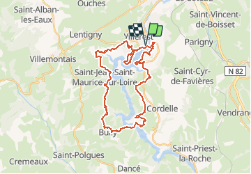
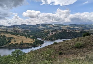
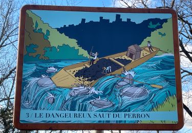
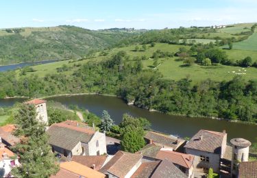
Parking et départ proche du Barrage de Villerest. Franchissant la Loire par le Barrage de Villerest et par le pont de Presle, ce circuit fait découvrir, le barrage, la table d’orientation, le cadran, le train touristique des belvédères, le mini-golf, le pont de Presle, le port de Bully, le village historique de Saint-Jean-Saint-Maurice-sur-Loire, le port de la Caille, les gorges du Lourdon, le lac de Villerest, son phare (point d’information touristique) et sa plage. Le parcours est relativement physique et technique et comporte quelques portions où il faudra pousser le VTT. Après la table d’orientation et le cadran, il faudra poser le pied par terre pour descendre les escaliers qui rejoignent la voie ferrée du petit train des belvédères. La beauté des gorges de la Loire et la splendeur des paysages observés laissent des souvenirs gravés à tout jamais.
Positioning
Comments
Trails nearby
![Trail Mountain bike Commelle-Vernay - VTT dans le bois de Terrenoire et au bord du Rhins - Commelle Vernay - Photo](https://media.geolcdn.com/t/375/260/ext.jpg?maxdim=2&url=https%3A%2F%2Fservices.sitytrail.com%2FGeolivesWS%2FDownloadMedia.ashx%3FTrailID%3D318053%26Media%3D17525_4.jpg)
![Mountain bike Mountain bike](https://static1.geolcdn.com/sitytour/trail-icons/202.png)
Mountain bike
![](/images/other/stat-length.png)
![](https://static1.geolcdn.com/siteimages/upload/files/16400158638029165_repeat_loop_refresh_sync_direction_icon.png)
![Trail Walking Saint-Jean-Saint-Maurice-sur-Loire - Autour des Gorges de la Loire - PR N° 9 : Sur le pas des pèlerins - Saint-Jean-Saint-Maurice-sur-Loire - Photo](https://media.geolcdn.com/t/375/260/ext.jpg?maxdim=2&url=https%3A%2F%2Fservices.sitytrail.com%2FGeolivesWS%2FDownloadMedia.ashx%3FTrailID%3D215167%26Media%3D15769_6.jpg)
![Walking Walking](https://static1.geolcdn.com/sitytour/trail-icons/101.png)
Walking
![](/images/other/stat-length.png)
![](https://static1.geolcdn.com/siteimages/upload/files/16400158638029165_repeat_loop_refresh_sync_direction_icon.png)
![Trail Walking Saint-Jean-Saint-Maurice-sur-Loire - Saint -Jean Saint -Maurice sur Loire - Photo](https://media.geolcdn.com/t/375/260/1053c594-4557-4a01-9659-5504d28a00d0.jpg&format=jpg&maxdim=2)
![Walking Walking](https://static1.geolcdn.com/sitytour/trail-icons/101.png)
Walking
![](/images/other/stat-length.png)
![](https://static1.geolcdn.com/siteimages/upload/files/16400158638029165_repeat_loop_refresh_sync_direction_icon.png)
![Trail Walking Saint-Cyr-de-Favières - Cordelle : Bois de Terrenoire - Photo](https://media.geolcdn.com/t/375/260/83c50546-4cae-443c-a80b-cd81d4b0f56f.jpg&format=jpg&maxdim=2)
![Walking Walking](https://static1.geolcdn.com/sitytour/trail-icons/101.png)
Walking
![](/images/other/stat-length.png)
![](https://static1.geolcdn.com/siteimages/upload/files/16400158638029165_repeat_loop_refresh_sync_direction_icon.png)
![Trail Walking Cordelle - boucle rilly-9.7 km - Photo](https://media.geolcdn.com/t/375/260/70cbec56-e75d-4971-a31c-1db03be10e15.jpg&format=jpg&maxdim=2)
![Walking Walking](https://static1.geolcdn.com/sitytour/trail-icons/101.png)
Walking
![](/images/other/stat-length.png)
![](https://static1.geolcdn.com/siteimages/upload/files/16400158638029165_repeat_loop_refresh_sync_direction_icon.png)
![Trail Walking Ouches - Ouches : de la plaine à la côte roannaise - Photo](https://media.geolcdn.com/t/375/260/6b9e8121-0a01-4791-9e45-beccd7d62b78.jpg&format=jpg&maxdim=2)
![Walking Walking](https://static1.geolcdn.com/sitytour/trail-icons/101.png)
Walking
![](/images/other/stat-length.png)
![](https://static1.geolcdn.com/siteimages/upload/files/16400158638029165_repeat_loop_refresh_sync_direction_icon.png)
![Trail Walking Cordelle - Cordelle : Terrenoire et versant sud - Photo](https://media.geolcdn.com/t/375/260/dfd1ec12-e45d-43ae-9a56-cd1f4a318fa5.jpg&format=jpg&maxdim=2)
![Walking Walking](https://static1.geolcdn.com/sitytour/trail-icons/101.png)
Walking
![](/images/other/stat-length.png)
![](https://static1.geolcdn.com/siteimages/upload/files/16400158638029165_repeat_loop_refresh_sync_direction_icon.png)
![Trail On foot Commelle-Vernay - Commelle-Vernay : petit train touristique - Photo](https://media.geolcdn.com/t/375/260/25e5a88d-0a40-4783-a608-61f5fa58e2c4.jpg&format=jpg&maxdim=2)
![On foot On foot](https://static1.geolcdn.com/sitytour/trail-icons/100.png)
On foot
![](/images/other/stat-length.png)
![](https://static1.geolcdn.com/siteimages/upload/files/16400158638029165_repeat_loop_refresh_sync_direction_icon.png)
![Trail Walking Saint-Jean-Saint-Maurice-sur-Loire - St Jean-St Maurice 18km - Photo](https://media.geolcdn.com/t/375/260/930956ea-3504-4ab8-b415-5247c26b90ff.jpg&format=jpg&maxdim=2)
![Walking Walking](https://static1.geolcdn.com/sitytour/trail-icons/101.png)
Walking
![](/images/other/stat-length.png)
![](https://static1.geolcdn.com/siteimages/upload/files/16400158638029165_repeat_loop_refresh_sync_direction_icon.png)