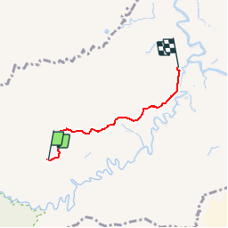
![](/images/other/stat-length.png)
![Trail Running Lamentin - Cascade de Bois Banane - Ravine Chaude - Photo](https://media.geolcdn.com/t/1900/400/ext.pjpeg?maxdim=2&url=https%3A%2F%2Fservices.sitytrail.com%2FGeolivesWS%2FDownloadMedia.ashx%3FTrailID%3D316820%26Media%3D14146_3.jpg)
Cascade de Bois Banane - Ravine Chaude
tracegps
User
![Length](/images/other/stat-length.png)
![Max alt](https://static1.geolcdn.com/siteimages/upload/files/1508320355ic_sort_altitude_max_24dp.png)
![Uphill gradient](https://static1.geolcdn.com/siteimages/upload/files/1508320355ic_sort_den_pos_24dp.png)
![Km-Effort](/images/other/stat-length.png)
![Min alt](https://static1.geolcdn.com/siteimages/upload/files/1508320355ic_sort_altitude_min_24dp.png)
![Downhill gradient](https://static1.geolcdn.com/siteimages/upload/files/1508320355ic_sort_den_neg_24dp.png)
![Boucle](https://static1.geolcdn.com/siteimages/upload/files/16400158638029165_repeat_loop_refresh_sync_direction_icon.png)
![Running](https://static1.geolcdn.com/sitytour/trail-icons/103.png)
2h00
Difficulty : Medium
![Scan this QR Code to open this trail in the SityTrail application](https://capi.geolives.com/qq0zvz2zws4bq2lad0pu/sitytour/trails/316820/qr.png?size=200)
FREE GPS app for hiking
About
Trail Running of 4.6 km to be discovered at Guadeloupe, Unknown, Lamentin. This trail is proposed by tracegps.
Description
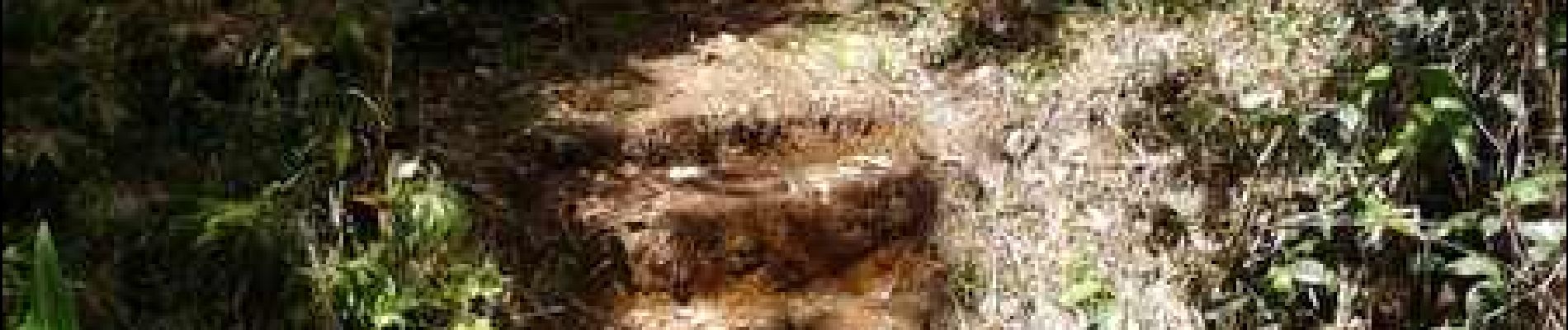
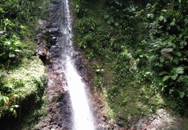
Très belle cascade dans la forêt, beau bassin pour la baignade et un pique-nique. Sur la piste forestière de Guyonneau, après 3,6 km de montée facile, prendre à gauche un sentier balisé en vert fluo sur les arbres. Le dénivelé s'accentue alors jusqu'à l'arrivée en montée puis en descente tout en restant bien praticable.
Positioning
Comments
Trails nearby
![Trail On foot Petit-Bourg - Trace des ruisseaux - Photo](https://media.geolcdn.com/t/375/260/d5056249-cb72-48a2-a972-b2191b472cd9.jpeg&format=jpg&maxdim=2)
![On foot On foot](https://static1.geolcdn.com/sitytour/trail-icons/100.png)
On foot
![](/images/other/stat-length.png)
![](https://static1.geolcdn.com/siteimages/upload/files/16400158638029165_repeat_loop_refresh_sync_direction_icon.png)
![Trail Trail Petit-Bourg - Forêt de Celus - Photo](https://media.geolcdn.com/t/375/260/a84bb18e-4db5-45c8-9cce-1077f3691a97.jpg&format=jpg&maxdim=2)
![Trail Trail](https://static1.geolcdn.com/sitytour/trail-icons/104.png)
Trail
![](/images/other/stat-length.png)
![](https://static1.geolcdn.com/siteimages/upload/files/16400158638029165_repeat_loop_refresh_sync_direction_icon.png)
![Trail Walking Petit-Bourg - Guadeloupe - Saut de la Lézarde - Photo](https://media.geolcdn.com/t/375/260/f417a0bd-5c8f-4104-a48b-b15e3121cb4a.jpg&format=jpg&maxdim=2)
![Walking Walking](https://static1.geolcdn.com/sitytour/trail-icons/101.png)
Walking
![](/images/other/stat-length.png)
![](https://static1.geolcdn.com/siteimages/upload/files/16400158638029165_repeat_loop_refresh_sync_direction_icon.png)
![Trail Trail Petit-Bourg - IRA - Photo](https://media.geolcdn.com/t/375/260/7f768d10-aac5-47c6-88ae-c34d177f63d9.jpg&format=jpg&maxdim=2)
![Trail Trail](https://static1.geolcdn.com/sitytour/trail-icons/104.png)
![Trail Walking Lamentin - Cascade Bois Banane - Photo](https://media.geolcdn.com/t/375/260/1bb992c2-4776-465a-8daf-1b693d77d88e.jpg&format=jpg&maxdim=2)
![Walking Walking](https://static1.geolcdn.com/sitytour/trail-icons/101.png)
Walking
![](/images/other/stat-length.png)
![](https://static1.geolcdn.com/siteimages/upload/files/16400158638029165_repeat_loop_refresh_sync_direction_icon.png)
![Trail Trail Petit-Bourg - IRA - Photo](https://media.geolcdn.com/t/375/260/9cee3d8c-eef6-452d-9644-d5b0817b1884.jpg&format=jpg&maxdim=2)
![Trail Trail](https://static1.geolcdn.com/sitytour/trail-icons/104.png)
![Trail Walking Petit-Bourg - Piton de Bouillante - Photo](https://media.geolcdn.com/t/375/260/896bf328-025a-4d39-82de-8b0a45081bda.jpg&format=jpg&maxdim=2)
![Walking Walking](https://static1.geolcdn.com/sitytour/trail-icons/101.png)
Walking
![](/images/other/stat-length.png)
![](https://static1.geolcdn.com/siteimages/upload/files/16400158638029165_repeat_loop_refresh_sync_direction_icon.png)
![Trail Walking Pointe-Noire - la mamelle au pigeon - Photo](https://media.geolcdn.com/t/375/260/caf8306a-8a11-441a-ab38-9ee733efe26e.jpg&format=jpg&maxdim=2)
![Walking Walking](https://static1.geolcdn.com/sitytour/trail-icons/101.png)
Walking
![](/images/other/stat-length.png)
![](https://static1.geolcdn.com/siteimages/upload/files/16400158638029165_repeat_loop_refresh_sync_direction_icon.png)
![Trail Trail Petit-Bourg - Forêt de celus - Photo](https://media.geolcdn.com/t/375/260/549fe249-5bb3-4623-a892-6a076cb409ba.jpg&format=jpg&maxdim=2)
![Trail Trail](https://static1.geolcdn.com/sitytour/trail-icons/104.png)
Trail
![](/images/other/stat-length.png)
![](https://static1.geolcdn.com/siteimages/upload/files/16400158638029165_repeat_loop_refresh_sync_direction_icon.png)