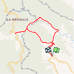
![](/images/other/stat-length.png)
![Trail Walking Saint-Joseph - Forêt de Rabuchon - Photo](https://media.geolcdn.com/t/1900/400/ext.pjpeg?maxdim=2&url=https%3A%2F%2Fservices.sitytrail.com%2FGeolivesWS%2FDownloadMedia.ashx%3FTrailID%3D316815%26Media%3D10634_4.jpg)
Forêt de Rabuchon
tracegps
User
![Length](/images/other/stat-length.png)
![Max alt](https://static1.geolcdn.com/siteimages/upload/files/1508320355ic_sort_altitude_max_24dp.png)
![Uphill gradient](https://static1.geolcdn.com/siteimages/upload/files/1508320355ic_sort_den_pos_24dp.png)
![Km-Effort](/images/other/stat-length.png)
![Min alt](https://static1.geolcdn.com/siteimages/upload/files/1508320355ic_sort_altitude_min_24dp.png)
![Downhill gradient](https://static1.geolcdn.com/siteimages/upload/files/1508320355ic_sort_den_neg_24dp.png)
![Boucle](https://static1.geolcdn.com/siteimages/upload/files/16400158638029165_repeat_loop_refresh_sync_direction_icon.png)
![Walking](https://static1.geolcdn.com/sitytour/trail-icons/101.png)
4h00
Difficulty : Medium
![Scan this QR Code to open this trail in the SityTrail application](https://capi.geolives.com/qq0zvz2zws4bq2lad0pu/sitytour/trails/316815/qr.png?size=200)
FREE GPS app for hiking
About
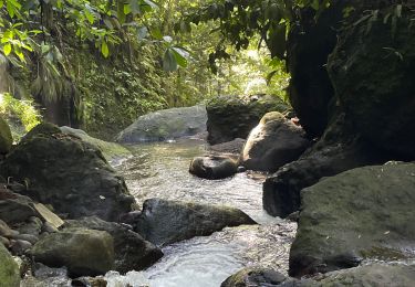
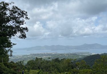
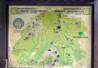
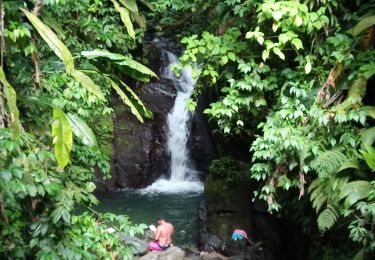
Trail Walking of 12 km to be discovered at Martinique, Unknown, Saint-Joseph. This trail is proposed by tracegps.
Description
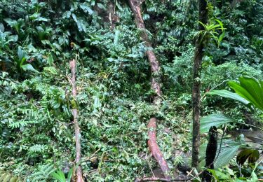
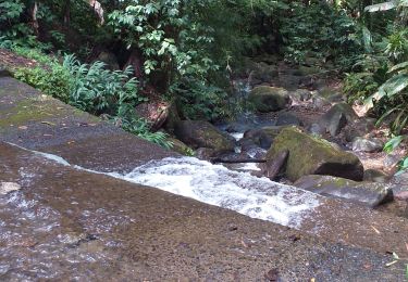
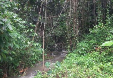
Très bon parcours pour la randonnée et surtout bon entrainement pour le trail. Je l'utilise régulièrement car c'est un terrain vallonné. La végétation est assez dense, et le terrain est assez glissant. Il y a aussi de la pente assez raide, mais pour faciliter l’ascension ils ont installés des marches. Bonne rando et course.
Positioning
Comments
Trails nearby
![Trail sport Fort-de-France - Absalon vers Didier - Photo](https://media.geolcdn.com/t/375/260/adf8a0b9-d2e0-4a1f-aaf4-a96938158482.jpg&format=jpg&maxdim=2)
sport
![](/images/other/stat-length.png)
![](https://static1.geolcdn.com/siteimages/upload/files/16400158638029165_repeat_loop_refresh_sync_direction_icon.png)
![Trail Walking Fort-de-France - fond barron - Photo](https://media.geolcdn.com/t/375/260/e47fa9db-42eb-4eae-be0a-ef7b2c9eca79.jpg&format=jpg&maxdim=2)
![Walking Walking](https://static1.geolcdn.com/sitytour/trail-icons/101.png)
Walking
![](/images/other/stat-length.png)
![](https://static1.geolcdn.com/siteimages/upload/files/16400158638029165_repeat_loop_refresh_sync_direction_icon.png)
![Trail Walking Fort-de-France - Absalon - Photo](https://media.geolcdn.com/t/375/260/878d5ce9-c2d9-41df-828d-f3fa710d1ba4.jpg&format=jpg&maxdim=2)
![Walking Walking](https://static1.geolcdn.com/sitytour/trail-icons/101.png)
Walking
![](/images/other/stat-length.png)
![](https://static1.geolcdn.com/siteimages/upload/files/16400158638029165_repeat_loop_refresh_sync_direction_icon.png)
![Trail Walking Saint-Joseph - Marche de bouliķi vers le bourg de st Joseph. - Photo](https://media.geolcdn.com/t/375/260/77d9f075-e645-4623-82b2-1841b98ea18b.jpg&format=jpg&maxdim=2)
![Walking Walking](https://static1.geolcdn.com/sitytour/trail-icons/101.png)
Walking
![](/images/other/stat-length.png)
![](https://static1.geolcdn.com/siteimages/upload/files/16400158638029165_repeat_loop_refresh_sync_direction_icon.png)
![Trail sport Fort-de-France - Didier absalon - Photo](https://media.geolcdn.com/t/375/260/554aad06-3441-4127-b415-2ba108c5a5e9.jpg&format=jpg&maxdim=2)
sport
![](/images/other/stat-length.png)
![](https://static1.geolcdn.com/siteimages/upload/files/16400158638029165_repeat_loop_refresh_sync_direction_icon.png)
![Trail sport Saint-Joseph - Boucle de rabuchon - Photo](https://media.geolcdn.com/t/375/260/73952a33-b4e2-4260-8c09-d51c749c2152.jpg&format=jpg&maxdim=2)
sport
![](/images/other/stat-length.png)
![](https://static1.geolcdn.com/siteimages/upload/files/16400158638029165_repeat_loop_refresh_sync_direction_icon.png)
![Trail sport Schœlcher - La Démarche-Morne Rose - Photo](https://media.geolcdn.com/t/375/260/8da19298-0e95-4207-a668-881dde22c6c8.jpg&format=jpg&maxdim=2)
sport
![](/images/other/stat-length.png)
![](https://static1.geolcdn.com/siteimages/upload/files/16400158638029165_repeat_loop_refresh_sync_direction_icon.png)
![Trail Walking Saint-Joseph - Morne des Olives - Photo](https://media.geolcdn.com/t/375/260/d9e2423b-fbf5-4b74-82cb-94b57e3fb56f.jpg&format=jpg&maxdim=2)
![Walking Walking](https://static1.geolcdn.com/sitytour/trail-icons/101.png)
Walking
![](/images/other/stat-length.png)
![](https://static1.geolcdn.com/siteimages/upload/files/16400158638029165_repeat_loop_refresh_sync_direction_icon.png)
![Trail Walking Fort-de-France - Circuit Absalon - Photo](https://media.geolcdn.com/t/375/260/caf6b968-ea56-4200-8f74-83c952609732.jpg&format=jpg&maxdim=2)
![Walking Walking](https://static1.geolcdn.com/sitytour/trail-icons/101.png)
Walking
![](/images/other/stat-length.png)
![](https://static1.geolcdn.com/siteimages/upload/files/16400158638029165_repeat_loop_refresh_sync_direction_icon.png)