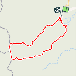
![](/images/other/stat-length.png)
![Trail Walking Sainte-Rose - De la source Sofaïa à Tête Allègre - Photo](https://media.geolcdn.com/t/1900/400/ext.pjpeg?maxdim=2&url=https%3A%2F%2Fservices.sitytrail.com%2FGeolivesWS%2FDownloadMedia.ashx%3FTrailID%3D316803%26Media%3D7298_2.jpg)
De la source Sofaïa à Tête Allègre
tracegps
User
![Length](/images/other/stat-length.png)
![Max alt](https://static1.geolcdn.com/siteimages/upload/files/1508320355ic_sort_altitude_max_24dp.png)
![Uphill gradient](https://static1.geolcdn.com/siteimages/upload/files/1508320355ic_sort_den_pos_24dp.png)
![Km-Effort](/images/other/stat-length.png)
![Min alt](https://static1.geolcdn.com/siteimages/upload/files/1508320355ic_sort_altitude_min_24dp.png)
![Downhill gradient](https://static1.geolcdn.com/siteimages/upload/files/1508320355ic_sort_den_neg_24dp.png)
![Boucle](https://static1.geolcdn.com/siteimages/upload/files/16400158638029165_repeat_loop_refresh_sync_direction_icon.png)
![Walking](https://static1.geolcdn.com/sitytour/trail-icons/101.png)
5h00
Difficulty : Difficult
![Scan this QR Code to open this trail in the SityTrail application](https://capi.geolives.com/qq0zvz2zws4bq2lad0pu/sitytour/trails/316803/qr.png?size=200)
FREE GPS app for hiking
About
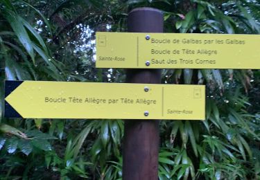
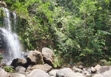
Trail Walking of 12 km to be discovered at Guadeloupe, Unknown, Sainte-Rose. This trail is proposed by tracegps.
Description
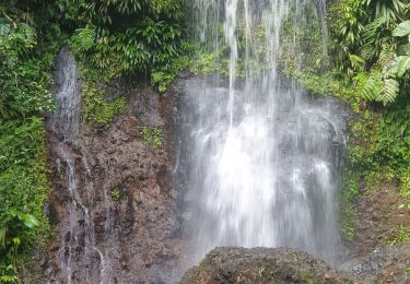
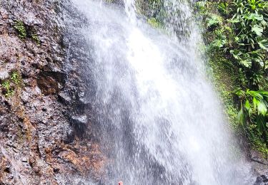
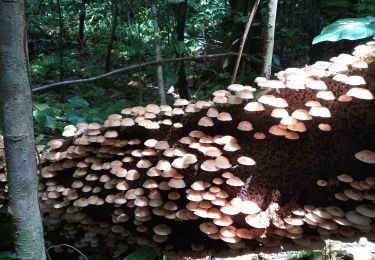
Ce circuit est facile en terme de balisage par contre les 6 premiers km ne sont que de la montée.... avec pas mal d'humidité, consolation a chaque intersection de crête : panorama de toute beauté sur chaque coté de l'ile. La seconde partie est une longue descente sur le Saut des 3 Cornes, petit arrêt rafraichissant, nettoyage et fraicheur avant de remonter par la trace botanique: aperçu de quelques essences de l'ile!
Positioning
Comments
Trails nearby
![Trail Walking Sainte-Rose - Guadeloupe - Saut des Trois Cornes - Sofaïa - Photo](https://media.geolcdn.com/t/375/260/889162c2-a04d-4747-bd9d-986e08e78077.jpg&format=jpg&maxdim=2)
![Walking Walking](https://static1.geolcdn.com/sitytour/trail-icons/101.png)
Walking
![](/images/other/stat-length.png)
![](https://static1.geolcdn.com/siteimages/upload/files/16400158638029165_repeat_loop_refresh_sync_direction_icon.png)
![Trail Walking Sainte-Rose - Guadeloupe - Saut des Trois Cornes - Sofaïa - Photo](https://media.geolcdn.com/t/375/260/3eee3c0d-87f9-4d5a-83ce-45578722f068.jpg&format=jpg&maxdim=2)
![Walking Walking](https://static1.geolcdn.com/sitytour/trail-icons/101.png)
Walking
![](/images/other/stat-length.png)
![](https://static1.geolcdn.com/siteimages/upload/files/16400158638029165_repeat_loop_refresh_sync_direction_icon.png)
![Trail Walking Sainte-Rose - Cascade Naca - Photo](https://media.geolcdn.com/t/375/260/bcfc92a6-f629-44e4-b43a-02f6a51e129e.jpg&format=jpg&maxdim=2)
![Walking Walking](https://static1.geolcdn.com/sitytour/trail-icons/101.png)
Walking
![](/images/other/stat-length.png)
![](https://static1.geolcdn.com/siteimages/upload/files/16400158638029165_repeat_loop_refresh_sync_direction_icon.png)
![Trail Trail Sainte-Rose - La boucle tête allègre galba - Photo](https://media.geolcdn.com/t/375/260/3e44aaf3-4a5f-41ed-80d6-b4719ef2ae9a.jpg&format=jpg&maxdim=2)
![Trail Trail](https://static1.geolcdn.com/sitytour/trail-icons/104.png)
Trail
![](/images/other/stat-length.png)
![](https://static1.geolcdn.com/siteimages/upload/files/16400158638029165_repeat_loop_refresh_sync_direction_icon.png)
![Trail Walking Sainte-Rose - madelonnette - Photo](https://media.geolcdn.com/t/375/260/5e793897-aea5-4d3d-b1eb-7226a3f8241d.jpg&format=jpg&maxdim=2)
![Walking Walking](https://static1.geolcdn.com/sitytour/trail-icons/101.png)
Walking
![](/images/other/stat-length.png)
![](https://static1.geolcdn.com/siteimages/upload/files/16400158638029165_repeat_loop_refresh_sync_direction_icon.png)
![Trail sport Sainte-Rose - Cascade de Bis - Photo](https://media.geolcdn.com/t/375/260/fc473a11-eaf2-442b-809a-d1818fc4d01b.jpg&format=jpg&maxdim=2)
sport
![](/images/other/stat-length.png)
![](https://static1.geolcdn.com/siteimages/upload/files/16400158638029165_repeat_loop_refresh_sync_direction_icon.png)
![Trail 4x4 Sainte-Rose - Trace vanille - Photo](https://media.geolcdn.com/t/375/260/ec2bd17a-78f9-45d0-a11b-6dcb807fb7ac.jpg&format=jpg&maxdim=2)
![4x4 4x4](https://static1.geolcdn.com/sitytour/trail-icons/403.png)
4x4
![](/images/other/stat-length.png)
![](https://static1.geolcdn.com/siteimages/upload/files/16400158638029165_repeat_loop_refresh_sync_direction_icon.png)
![Trail Walking Sainte-Rose - Saut des Trois Cornes, en boucle depuis les sources de Sofaia - Photo](https://media.geolcdn.com/t/375/260/55a2c3eb-22b3-4536-8b78-1f86344e3da8.jpg&format=jpg&maxdim=2)
![Walking Walking](https://static1.geolcdn.com/sitytour/trail-icons/101.png)
Walking
![](/images/other/stat-length.png)
![](https://static1.geolcdn.com/siteimages/upload/files/16400158638029165_repeat_loop_refresh_sync_direction_icon.png)
![Trail On foot Sainte-Rose - Solitude - Photo](https://media.geolcdn.com/t/375/260/ext.jpg?maxdim=2&url=https%3A%2F%2Fstatic1.geolcdn.com%2Fsiteimages%2Fupload%2Ffiles%2F1545311037marcheuse_200dpi.jpg)
![On foot On foot](https://static1.geolcdn.com/sitytour/trail-icons/100.png)
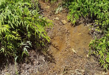
Super trace, boueuse, très physique.. 9 km de monter pour commencer... prévoir minimum 2 bouteilles d'eau par personne. Attention!!!! la boucle fait 24,4 km en réalité... Pas 12 km comme indiqué sur le panneau ONF. Bonne trace!
bonne piste. très boueuse. attention ça glisse... il faut de bonnes chaussures. à faire